 view gallery view gallery S1 km S1 km
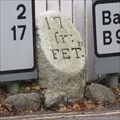
|   B974 Milestone - Bridge of Feugh, Banchory, Aberdeenshire. B974 Milestone - Bridge of Feugh, Banchory, Aberdeenshire.
in Milestones Milestone on the B974 road to the south of the town of Banchory at the Bridge of Feugh. posted by:  creg-ny-baa creg-ny-baa location: Northern Scotland, United Kingdom date approved: 10/07/2019 last visited: never |
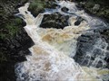 view gallery view galleryS1 km |  Falls of Feugh - Banchory, Aberdeenshire, Scotland. Falls of Feugh - Banchory, Aberdeenshire, Scotland.
in Waterfalls Cascading falls at the Bridge of Feugh, famous for leaping salmon, on the south side of the Aberdeenshire town of Banchory. posted by: creg-ny-baa location: Northern Scotland, United Kingdom date approved: 08/21/2019 last visited: 08/08/2019 |
 view gallery view gallery SE1 km SE1 km
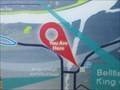
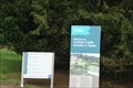
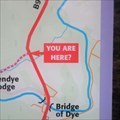
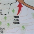
|  You Are Here - Banchory, Aberdeenshire, Scotland. You Are Here - Banchory, Aberdeenshire, Scotland.
in 'You Are Here' Maps 'You Are Here' at the Bridge of Feugh Car Park on the south side of the Aberdeenshire town of Banchory. posted by: creg-ny-baa location: Northern Scotland, United Kingdom date approved: 08/19/2019 last visited: never |
 view gallery view gallery W2.1 km W2.1 km
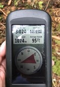
|  jonathanatpsu - 57°02.842 jonathanatpsu - 57°02.842
in Where's In A Name? My name in coordinates from Scotland posted by: jonathanatpsu location: Northern Scotland, United Kingdom date approved: 09/04/2017 last visited: 08/10/2019 |
 view gallery view gallery SW2.7 km SW2.7 km
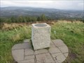
|  Scolty View Indicator - Banchory, Aberdeenshire. Scolty View Indicator - Banchory, Aberdeenshire.
in Orientation Tables Two bronze discs on granite pillars, situated on the hill of Scolty, south-west of the Aberdeenshire town of Banchory in Scotland. posted by: creg-ny-baa location: Northern Scotland, United Kingdom date approved: 10/06/2019 last visited: never |
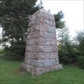
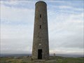 view gallery view gallerySW2.7 km |  General Burnett Memorial Tower - Banchory, Aberdeenshire. General Burnett Memorial Tower - Banchory, Aberdeenshire.
in Specific Veteran Memorials Tall circular tower on the summit of Scolty, a hill to the south-west of the town of Banchory, commemorating General William Burnett. posted by: creg-ny-baa location: Northern Scotland, United Kingdom date approved: 10/08/2019 last visited: never |
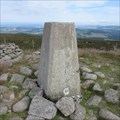
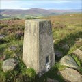
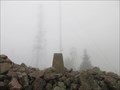
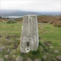 view gallery view gallerySW2.7 km |  O.S. Triangulation Pillar - Scolty, Banchory, Aberdeenshire. O.S. Triangulation Pillar - Scolty, Banchory, Aberdeenshire.
in U.K. and Ireland Trigpoints Ordnance Survey trig pillar, constructed in 1949, on the summit of Scolty, a hill to the south-west of the town of Banchory. posted by: creg-ny-baa location: Northern Scotland, United Kingdom date approved: 10/27/2019 last visited: never |
 view gallery view gallery E3.7 km E3.7 km
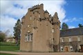
|  Crathes Castle - Banchory, Scotland Crathes Castle - Banchory, Scotland
in Castles [EN] Crathes Castle is a 16th century castle built by the Burnett family owners for over 400 years. [FR] Le château de Crathes est un château du XVIe siècle construit par la famille Burnett propriétaire pendant plus de 400 ans. posted by:  pmaupin pmaupin location: Northern Scotland, United Kingdom date approved: 04/22/2024 last visited: never |
 view gallery view galleryE3.7 km |  Crathes Castle - Banchory, Scotland, UK Crathes Castle - Banchory, Scotland, UK
in Wikipedia Entries [EN] Crathes Castle is a 16th century castle built by the Burnett family owners for over 400 years.
[FR] Le château de Crathes est un château du XVIe siècle construit par la famille Burnett propriétaire pendant plus de 400 ans. posted by: pmaupin location: Northern Scotland, United Kingdom date approved: 04/21/2024 last visited: never |
 view gallery view galleryE3.7 km |  Crathes Castle - Banchory, Scotland, UK Crathes Castle - Banchory, Scotland, UK
in National Trust U.K. [EN] Crathes Castle is a 16th century castle built by the Burnett family owners for over 400 years.
[FR] Le château de Crathes est un château du XVIe siècle construit par la famille Burnett propriétaire pendant plus de 400 ans. posted by: pmaupin location: Northern Scotland, United Kingdom date approved: 04/23/2024 last visited: never |
 view gallery view galleryE3.7 km |  Crathes Castle - Banchory, Scotland, UK Crathes Castle - Banchory, Scotland, UK
in English Heritage - Cadw - Historic Scotland [EN] Crathes Castle is a 16th century castle built by the Burnett family owners for over 400 years. [FR] Le château de Crathes est un château du XVIe siècle construit par la famille Burnett propriétaire pendant plus de 400 ans. posted by: pmaupin location: Northern Scotland, United Kingdom date approved: 04/21/2024 last visited: never |
 view gallery view galleryE3.7 km |  Crathes Castle - Banchory, Scotland, UK Crathes Castle - Banchory, Scotland, UK
in Satellite Imagery Oddities [EN] Crathes Castle is a 16th century castle built by the Burnett family owners for over 400 years. [FR] Le château de Crathes est un château du XVIe siècle construit par la famille Burnett propriétaire pendant plus de 400 ans. posted by: pmaupin location: Northern Scotland, United Kingdom date approved: 04/24/2024 last visited: never |
 view gallery view gallery NE4 km NE4 km
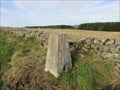
| O.S. Triangulation Pillar - The Neuk, Aberdeenshire. in U.K. and Ireland Trigpoints Ordnance Survey trig pillar in a low lying field two miles north-east of the Aberdeenshire town of Banchory. posted by: creg-ny-baa location: Northern Scotland, United Kingdom date approved: 11/19/2017 last visited: 08/10/2019 |
 view gallery view galleryW5.8 km | O.S. Triangulation Pillar - Hill of Tillylair, Aberdeenshire. in U.K. and Ireland Trigpoints Ordnance Survey trig pillar, constructed in 1949, on a hillock on the south side of a vast wooded area four miles west of the Aberdeenshire town of Banchory. posted by: creg-ny-baa location: Northern Scotland, United Kingdom date approved: 10/07/2020 last visited: never |
 view gallery view galleryS7.9 km | O.S. Triangulation Pillar - Kerloch, Aberdeenshire in U.K. and Ireland Trigpoints Ordnance Survey trig pillar, constructed in 1950, on the summit of Kerloch, an eastern outpost of the Grampian Mountains, five miles south of the Aberdeenshire town of Banchory. posted by: creg-ny-baa location: Northern Scotland, United Kingdom date approved: 07/25/2022 last visited: never |
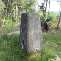
 view gallery view gallerySW8.4 km | O.S. Triangulation Pillar - Cuttie's Hillock, Aberdeenshire. in U.K. and Ireland Trigpoints Ordnance Survey trig pillar, constructed in 1949, in the midst of Cuttie's Wood, five miles south-west of Banchory in Aberdeenshire. posted by: creg-ny-baa location: Northern Scotland, United Kingdom date approved: 05/18/2020 last visited: never |
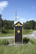 view gallery view gallerySW8.4 km |  AA - Glen Dye Box AA - Glen Dye Box
in Automobile Association Signs Vintage AA call box. Situated at a road junction on the B974 a few miles north of Bridge of Dye. posted by: RandomPrecision location: Northern Scotland, United Kingdom date approved: 09/02/2013 last visited: 08/18/2019 |
 view gallery view galleryW8.4 km | O.S. Triangulation Pillar - Tom's Cairn, Aberdeenshire. in U.K. and Ireland Trigpoints Ordnance Survey trig pillar, constructed in 1949, on the summit of Tom's Cairn, a 310 metre hill in Aberdeenshire between the towns of Aboyne and Banchory. posted by: creg-ny-baa location: Northern Scotland, United Kingdom date approved: 10/02/2020 last visited: never |
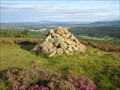 view gallery view galleryW8.4 km |  Tom's Cairn - Aberdeenshire, Scotland. Tom's Cairn - Aberdeenshire, Scotland.
in Cairns Tom's Cairn is a four foot high cairn on the summit of the hill of the same name in the Aberdeenshire countryside between the towns of Aboyne and Banchory. posted by: creg-ny-baa location: Northern Scotland, United Kingdom date approved: 09/08/2020 last visited: never |
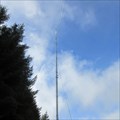 view gallery view gallerySE8.9 km |  Durris Transmitter - Aberdeenshire, Scotland. Durris Transmitter - Aberdeenshire, Scotland.
in Radio and Television Transmitter Towers The tallest structure in Scotland serves the bulk of the north-east of the country as well as over a hundred miles of the east coast. posted by: creg-ny-baa location: Northern Scotland, United Kingdom date approved: 09/24/2017 last visited: never |
 view gallery view gallerySE9.3 km | O.S. Triangulation Pillar - Cairn-mon-earn, Aberdeenshire. in U.K. and Ireland Trigpoints Ordnance Survey trig pillar on the 378 metre summit of Cairn-mon-earn in Durris Forest at the eastern extremity of the Grampian Mountains. posted by: creg-ny-baa location: Northern Scotland, United Kingdom date approved: 10/17/2017 last visited: never |
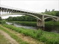 view gallery view galleryE10 km |  Park Bridge - Drumoak, Aberdeenshire, Scotland Park Bridge - Drumoak, Aberdeenshire, Scotland
in Arch Bridges Two span cast-iron arches carrying the C35K road over the River Dee near the Aberdeenshire village of Drumoak, now currently closed to traffic and only available for use by pedestrians and cyclists. posted by: creg-ny-baa location: Northern Scotland, United Kingdom date approved: 06/21/2022 last visited: never |
 view gallery view gallerySW10.3 km | You Are Here - Glen Dye Car Park, Aberdeenshire. in 'You Are Here' Maps 'You are here' in the car parking area by the B974 in Glen Dye, Aberdeenshire in Scotland, the start of the walk up to the hill of Clachnaben. posted by: creg-ny-baa location: Northern Scotland, United Kingdom date approved: 04/29/2019 last visited: never |
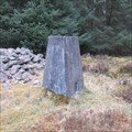
 view gallery view galleryW10.5 km |  Birse Parish War Memorial - Aberdeenshire, Scotland. Birse Parish War Memorial - Aberdeenshire, Scotland.
in World War I Memorials and Monuments The war memorial dedicated to the men of the parish of Birse in Aberdeenshire, a tapering granite block set by the roadside of the B976. posted by: creg-ny-baa location: Northern Scotland, United Kingdom date approved: 09/03/2020 last visited: never |
 view gallery view galleryW10.5 km | You Are Here - Corsedardar, Aberdeenshire, Scotland. in 'You Are Here' Maps 'You Are Here' on the B976 road at Corsedardar, in the parish of Birse in Aberdeenshire, next to two standing stones and the Birse War Memorial. posted by: creg-ny-baa location: Northern Scotland, United Kingdom date approved: 09/06/2020 last visited: never |
|