 view gallery view gallery NE0.2 km NE0.2 km
|   West Ham Cemetery - London, UK West Ham Cemetery - London, UK
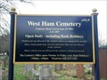
in Worldwide Cemeteries A 22 acre, active cemetery in the Forest Gate area of east London. posted by:  OrientGeo OrientGeo location: London, United Kingdom date approved: 02/20/2021 last visited: 02/21/2021 |
 view gallery view gallery N0.3 km N0.3 km
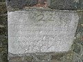
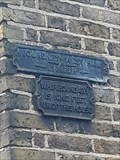
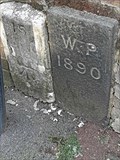
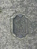
|  West Ham Parish Boundary Marker 23 - West Ham Cemetery, London, UK West Ham Parish Boundary Marker 23 - West Ham Cemetery, London, UK
in Public Land Survey Marks A parish boundary marker in the form of a stone tablet set into a wall, marking the boundary between West Ham Parish and Wanstead Parish. posted by: OrientGeo location: London, United Kingdom date approved: 02/13/2021 last visited: 02/21/2021 |
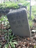 view gallery view galleryN0.3 km | West Ham Parish Boundary Marker 22C - West Ham Cemetery, London, UK in Public Land Survey Marks A parish boundary marker in the form of a stone post set into the ground, marking the boundary between West Ham Parish and Cann Hall Parish. posted by: OrientGeo location: London, United Kingdom date approved: 02/13/2021 last visited: 02/21/2021 |
 view gallery view gallery W0.3 km W0.3 km
| West Ham Parish Boundary Marker - Cruikshank Road, London, UK in Public Land Survey Marks A parish boundary marker in the form of a small metal plate set into the kerbstone, marking the boundary between West Ham Parish and Cann Hall Parish. posted by: OrientGeo location: London, United Kingdom date approved: 02/01/2021 last visited: 02/12/2021 |
 view gallery view gallery SW0.3 km SW0.3 km
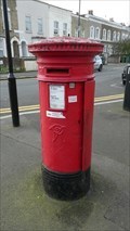
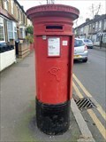
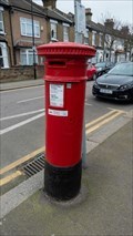
|  Victorian Post Box - Buxton Road, London, UK Victorian Post Box - Buxton Road, London, UK
in Victorian Post Boxes This Victorian post box stands on the north side of Buxton Road at the junction with Hatfield Road in east London. posted by:  Master Mariner Master Mariner location: London, United Kingdom date approved: 02/19/2021 last visited: 02/26/2021 |
 view gallery view galleryNE0.3 km | West Ham Parish Boundary Marker - Odessa Road, London, UK in Public Land Survey Marks A parish boundary marker in the form of two iron plates affixed to the wall of a house, marking the boundary between West Ham Parish and Cann Hall Parish. posted by: OrientGeo location: London, United Kingdom date approved: 02/14/2021 last visited: 02/21/2021 |
 view gallery view galleryW0.3 km | Victorian Post Box - Janson Road, London, UK in Victorian Post Boxes This Victorian post box is located on the north side of Janson Road, about halfway along its length, in east London. posted by: Master Mariner location: London, United Kingdom date approved: 02/17/2021 last visited: 02/19/2021 |
 view gallery view gallery SE0.5 km SE0.5 km
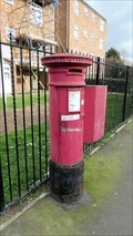
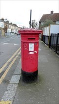
| Victorian Post Box - Odessa Road, London, UK in Victorian Post Boxes This Victorian post box is located on the south west side of Odessa Road at the junction with Forest Lane in Forest Gate, east London. posted by: Master Mariner location: London, United Kingdom date approved: 06/18/2022 last visited: never |
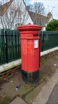
 view gallery view galleryN0.5 km | Victorian Post Box - Odessa Road, London, UK in Victorian Post Boxes A Victorian pillar box located on Odessa Road, London, in the Forest Gate / Leytonstone border area. posted by: OrientGeo location: London, United Kingdom date approved: 02/13/2021 last visited: 02/21/2021 |
 view gallery view galleryW0.5 km | West Ham Parish Boundary Marker - Leytonstone Road, London, UK in Public Land Survey Marks A parish boundary marker in the form of a small metal plate set into the kerbstone, marking the boundary between West Ham Parish and Cann Hall Parish. posted by: OrientGeo location: London, United Kingdom date approved: 02/01/2021 last visited: 02/12/2021 |
 view gallery view galleryW0.5 km | Victorian Post Box - Borthwick Road, London, UK in Victorian Post Boxes This Victorian post box is located on the south side of Borthwick Road at the junction with Leytonstone Road in east London. posted by: Master Mariner location: London, United Kingdom date approved: 02/17/2021 last visited: 02/19/2021 |
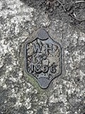
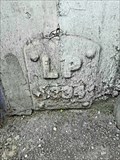
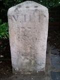 view gallery view galleryW0.6 km | West Ham Parish Boundary Marker in Public Land Survey Marks West Ham Parish Boundary Marker posted by: Batloaf location: London, United Kingdom date approved: 01/28/2012 last visited: 12/24/2020 |
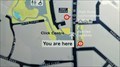
 view gallery view galleryW0.6 km |  You Are Here - Crownfield Road, London, UK You Are Here - Crownfield Road, London, UK
in 'You Are Here' Maps This "you are here" map is located on the south side of Crownfield Road at the junction with High Road Leytonstone. posted by: Master Mariner location: London, United Kingdom date approved: 02/17/2021 last visited: never |
 view gallery view galleryNE0.6 km | A Pair of Parish Boundary Markers - Dames Road, London, UK in Public Land Survey Marks A pair of parish boundary stones, set into a modern brick wall, marking the boundary between West Ham Parish and Wanstead Parish. posted by: OrientGeo location: London, United Kingdom date approved: 02/13/2021 last visited: 02/21/2021 |
 view gallery view gallery NW0.6 km NW0.6 km
| Leyton Parish Boundary Marker - High Road, Leytonstone, London, UK in Public Land Survey Marks A parish boundary marker in the form of a metal plate set into a wall, marking the boundary between Leyton Parish and Cann Hall Parish. posted by: OrientGeo location: London, United Kingdom date approved: 02/20/2021 last visited: 02/21/2021 |
 view gallery view galleryNW0.8 km | You Are Here - High Road Leytonstone, London, UK in 'You Are Here' Maps This "you are here" map is located on the west side of High Road Leytonstone at Jubilee Gardens. posted by: Master Mariner location: London, United Kingdom date approved: 02/17/2021 last visited: never |
 view gallery view gallerySW0.8 km |  Maryland Railway Station - Leytonstone Road, London, UK Maryland Railway Station - Leytonstone Road, London, UK
in Wikipedia Entries Maryland railway station is located on the south side of Leytonstone Road in east London. The station handles services operated by TfL Rail with four sets of tracks passing through it. The platforms are interconnected by foot bridges. posted by: Master Mariner location: London, United Kingdom date approved: 02/17/2021 last visited: never |
 view gallery view gallerySW0.8 km |  Maryland Railway Station - Leytonstone Road, London, UK Maryland Railway Station - Leytonstone Road, London, UK
in News Article Locations Radical councillors in the London Borough of Newham have called for Maryland railway station to be renamed as they claim the name, "Maryland", has links to the slave trade. posted by: Master Mariner location: London, United Kingdom date approved: 02/17/2021 last visited: never |
 view gallery view gallerySW0.8 km |  Maryland Railway Station - Leytonstone Road, London, UK Maryland Railway Station - Leytonstone Road, London, UK
in Train Stations/Depots Maryland railway station is located on the south side of Leytonstone Road in east London. The station handles services operated by TfL Rail with four sets of tracks passing through it. The platforms are interconnected by foot bridges. posted by: Master Mariner location: London, United Kingdom date approved: 02/17/2021 last visited: never |
 view gallery view gallery E0.8 km E0.8 km
| Forest Gate Railway Station - Woodgrange Road, London, UK in Wikipedia Entries On May 24th, after years of delay, London's newest underground line, the Elizabeth Line, finally opened. When complete it will run from Reading and Heathrow Airport in the west to Shenfield and Abbey Wood in the east. It is currently in three parts. posted by: Master Mariner location: London, United Kingdom date approved: 08/17/2022 last visited: never |
 view gallery view galleryE0.8 km |  Forest Gate Elizabeth Line Station - Woodgrange Road, London, UK Forest Gate Elizabeth Line Station - Woodgrange Road, London, UK
in The Underground On May 24th, after years of delay, London's newest underground line, the Elizabeth Line, finally opened. When complete it will run from Reading and Heathrow Airport in the west to Shenfield and Abbey Wood in the east. It is currently in three parts. posted by: Master Mariner location: London, United Kingdom date approved: 08/17/2022 last visited: never |
 view gallery view galleryNW0.8 km | Victorian Post Box - Selby Road, London, UK in Victorian Post Boxes This Victorian post box is located on the south west side of Selby Road at the junction with Napier Road in Leyton, east London. posted by: Master Mariner location: London, United Kingdom date approved: 06/18/2022 last visited: never |
 view gallery view galleryNE0.8 km | A Pair of Parish Boundary Markers - Knighton Road, London, UK in Public Land Survey Marks A pair of parish boundary markers, set into the kerbstones, marking the boundary between West Ham Parish and Cann Hall Parish. posted by: OrientGeo location: London, United Kingdom date approved: 02/18/2021 last visited: 02/21/2021 |
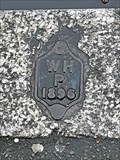
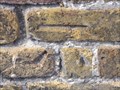 view gallery view galleryNW0.8 km |  Cut Bench Mark - Langthorne Close, London, UK Cut Bench Mark - Langthorne Close, London, UK
in U.K. and Ireland Trigpoints This cut mark is on a post that may have had a building stood behind it. posted by: Master Mariner location: London, United Kingdom date approved: 04/06/2012 last visited: 01/27/2021 |
 view gallery view galleryE0.8 km | Wanstead Park Railway Station - Woodgrange Road, London, UK in Wikipedia Entries Wanstead Park station handles services operated by London Overground. The tracks run in an east.west direction above street level with access to the platforms on north and south side of the tracks. posted by: Master Mariner location: London, United Kingdom date approved: 08/17/2022 last visited: never |
|