 view gallery view gallery SW7.2 km SW7.2 km
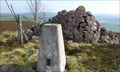
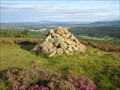
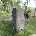
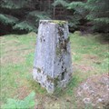
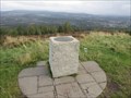
|   Top of Craiglich Mountain, NE Tarland, Scotland Top of Craiglich Mountain, NE Tarland, Scotland
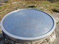
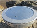
in U.K. and Ireland Trigpoints A flush bracket on a triangulation pillar on the top of the mountain with great 360 degree views! posted by:  lingbeek lingbeek location: Northern Scotland, United Kingdom date approved: 09/30/2011 last visited: never |
 view gallery view gallery N7.4 km N7.4 km
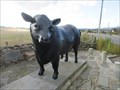
|  Aberdeen Angus Bull - Alford, Aberdeenshire, Scotland Aberdeen Angus Bull - Alford, Aberdeenshire, Scotland
in Figurative Public Sculpture Life size bronze sculpture of an Aberdeen Angus bull on the eastern approach to the Aberdeenshire village of Alford, where the breed was first established in the 1800s. posted by:  creg-ny-baa creg-ny-baa location: Northern Scotland, United Kingdom date approved: 10/20/2023 last visited: never |
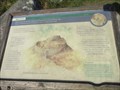
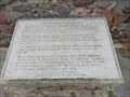 view gallery view galleryN7.4 km |  Aberdeen Angus - Alford, Aberdeenshire Aberdeen Angus - Alford, Aberdeenshire
in UK Historical Markers Stone plaque detailing the significance of the life size bronze sculpture of an Aberdeen Angus Bull that stands by the roadside on the eastern approach to the large Aberdeenshire village of Alford. posted by: creg-ny-baa location: Northern Scotland, United Kingdom date approved: 10/21/2023 last visited: never |
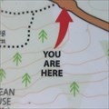
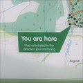
 view gallery view galleryN7.6 km |  You Are Here - Alford, Aberdeenshire, Scotland You Are Here - Alford, Aberdeenshire, Scotland
in 'You Are Here' Maps 'You Are Here' in the village car park in Alford, a large village in the centre of rural Aberdeenshire. posted by: creg-ny-baa location: Northern Scotland, United Kingdom date approved: 10/18/2023 last visited: never |
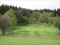
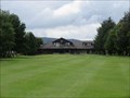 view gallery view galleryN7.9 km |  Alford Golf Club - Aberdeenshire, Scotland. Alford Golf Club - Aberdeenshire, Scotland.
in Public and Private Golf Courses Flat parkland course in the small Aberdeenshire town of Alford in Scotland. posted by: creg-ny-baa location: Northern Scotland, United Kingdom date approved: 08/27/2020 last visited: never |
 view gallery view gallery W9.8 km W9.8 km
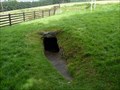
|  Culsh Earth House - Tarland, Scotland, UK Culsh Earth House - Tarland, Scotland, UK
in English Heritage - Cadw - Historic Scotland An Earth House with 2000 years!! posted by: tmob location: Northern Scotland, United Kingdom date approved: 11/28/2012 last visited: never |
 view gallery view gallerySW11.1 km | Aboyne Golf Club - Aberdeenshire, Scotland. in Public and Private Golf Courses Parkland/heathland golf course at the small town of Aboyne on Royal Deeside. posted by: creg-ny-baa location: Northern Scotland, United Kingdom date approved: 05/10/2018 last visited: never |
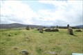 view gallery view gallerySW12.1 km |  Tomnaverie Stone Circle - Tarland, Scotland, UK Tomnaverie Stone Circle - Tarland, Scotland, UK
in Wikipedia Entries [EN] The Tomnaverie stone circle is a Bronze Age cromlech, comprising a massive lying stone.
[FR] Le cercle de pierre de Tomnaverie est un cromlech daté de l'Âge du bronze, comportant une pierre couchée massive. posted by: pmaupin location: Northern Scotland, United Kingdom date approved: 04/21/2024 last visited: never |
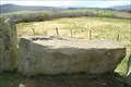 view gallery view gallerySW12.1 km | Tomnaverie Stone Circle - Tarland, Scotland, UK in English Heritage - Cadw - Historic Scotland [EN] The Tomnaverie stone circle is a Bronze Age cromlech, comprising a massive lying stone. [FR] Le cercle de pierre de Tomnaverie est un cromlech daté de l'Âge du bronze, comportant une pierre couchée massive. posted by: pmaupin location: Northern Scotland, United Kingdom date approved: 04/23/2024 last visited: never |
 view gallery view gallery S14.3 km S14.3 km
|  Tom's Cairn - Aberdeenshire, Scotland. Tom's Cairn - Aberdeenshire, Scotland.
in Cairns Tom's Cairn is a four foot high cairn on the summit of the hill of the same name in the Aberdeenshire countryside between the towns of Aboyne and Banchory. posted by: creg-ny-baa location: Northern Scotland, United Kingdom date approved: 09/08/2020 last visited: never |
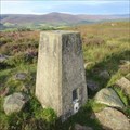 view gallery view galleryS14.3 km | O.S. Triangulation Pillar - Tom's Cairn, Aberdeenshire. in U.K. and Ireland Trigpoints Ordnance Survey trig pillar, constructed in 1949, on the summit of Tom's Cairn, a 310 metre hill in Aberdeenshire between the towns of Aboyne and Banchory. posted by: creg-ny-baa location: Northern Scotland, United Kingdom date approved: 10/02/2020 last visited: never |
 view gallery view galleryS14.6 km | You Are Here - Corsedardar, Aberdeenshire, Scotland. in 'You Are Here' Maps 'You Are Here' on the B976 road at Corsedardar, in the parish of Birse in Aberdeenshire, next to two standing stones and the Birse War Memorial. posted by: creg-ny-baa location: Northern Scotland, United Kingdom date approved: 09/06/2020 last visited: never |
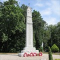
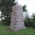 view gallery view galleryS14.6 km |  Birse Parish War Memorial - Aberdeenshire, Scotland. Birse Parish War Memorial - Aberdeenshire, Scotland.
in World War I Memorials and Monuments The war memorial dedicated to the men of the parish of Birse in Aberdeenshire, a tapering granite block set by the roadside of the B976. posted by: creg-ny-baa location: Northern Scotland, United Kingdom date approved: 09/03/2020 last visited: never |
 view gallery view galleryS15 km | O.S. Triangulation Pillar - Hill of Tillylair, Aberdeenshire. in U.K. and Ireland Trigpoints Ordnance Survey trig pillar, constructed in 1949, on a hillock on the south side of a vast wooded area four miles west of the Aberdeenshire town of Banchory. posted by: creg-ny-baa location: Northern Scotland, United Kingdom date approved: 10/07/2020 last visited: never |
 view gallery view gallery NE15.1 km NE15.1 km
| War Memorial - Kemnay, Aberdeenshire. in World War I Memorials and Monuments Tall granite megalithic column at the southern entrance to the Aberdeenshire village of Kemnay, honouring the fallen of World War I. posted by: creg-ny-baa location: Northern Scotland, United Kingdom date approved: 08/06/2018 last visited: never |
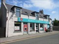 view gallery view galleryNE15.3 km |  Kemnay Post Office - Aberdeenshire, Scotland. Kemnay Post Office - Aberdeenshire, Scotland.
in UK Post Offices The post office in the Aberdeenshire village of Kemnay, which is also the local pharmacy. posted by: creg-ny-baa location: Northern Scotland, United Kingdom date approved: 08/11/2018 last visited: never |
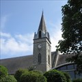 view gallery view galleryNE15.4 km |  Kemnay Church Centre - Aberdeenshire, Scotland. Kemnay Church Centre - Aberdeenshire, Scotland.
in Unique Steeples Steeple of the Kemnay Church Centre, formerly the Free Church, in the Aberdeenshire village of Kemnay posted by: creg-ny-baa location: Northern Scotland, United Kingdom date approved: 08/07/2018 last visited: never |
 view gallery view galleryNE15.4 km |  Oxen Craig of Bennachie Indicator - Aberdeenshire, Scotland. Oxen Craig of Bennachie Indicator - Aberdeenshire, Scotland.
in Orientation Tables Indicator on the summit of Oxen Craig, the highest point of Bennachie in Aberdeenshire, Scotland. posted by: creg-ny-baa location: Northern Scotland, United Kingdom date approved: 08/01/2018 last visited: never |
 view gallery view gallery SE15.6 km SE15.6 km
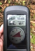
|  jonathanatpsu - 57°02.842 jonathanatpsu - 57°02.842
in Where's In A Name? My name in coordinates from Scotland posted by: jonathanatpsu location: Northern Scotland, United Kingdom date approved: 09/04/2017 last visited: 08/10/2019 |
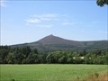 view gallery view galleryNE16.1 km | Bennachie - Aberdeenshire, Scotland. in Wikipedia Entries Prominent area of high ground rising out of the countryside of Aberdeenshire with historical connotations dating back to the Iron Age. posted by: creg-ny-baa location: Northern Scotland, United Kingdom date approved: 09/19/2018 last visited: never |
 view gallery view galleryNE16.1 km | Mither Tap of Bennachie Indicator - Aberdeenshire, Scotland in Orientation Tables Indicator on the rocky granite summit of Mither Tap in Aberdeenshire, Scotland. posted by: creg-ny-baa location: Northern Scotland, United Kingdom date approved: 07/30/2018 last visited: never |
 view gallery view galleryNE16.3 km | O.S. Triangulation Pillar - Cot-town Wood, Kemnay, Aberdeenshire in U.K. and Ireland Trigpoints Ordnance Survey trig pillar, constructed in 1949, in a small clearing at the top of a forested hill, just over a mile north of the large Aberdeenshire village of Kemnay. posted by: creg-ny-baa location: Northern Scotland, United Kingdom date approved: 07/07/2023 last visited: never |
 view gallery view galleryNE16.3 km | Mither Tap Pictish Fort - Aberdeenshire, Scotland. in UK Historical Markers Historical information board on the footpath just below the summit of the Mither Tap of Bennachie, outlining the details of the Pictish, or Iron Age fort, that once stood there. posted by: creg-ny-baa location: Northern Scotland, United Kingdom date approved: 07/31/2018 last visited: never |
 view gallery view galleryNE16.4 km | You Are Here - Bennachie Visitor Centre, Aberdeenshire. in 'You Are Here' Maps 'You are here' in the car park at Bennachie Visitor Centre in Aberdeenshire, Scotland. posted by: creg-ny-baa location: Northern Scotland, United Kingdom date approved: 07/29/2018 last visited: never |
 view gallery view gallerySE16.7 km | Scolty View Indicator - Banchory, Aberdeenshire. in Orientation Tables Two bronze discs on granite pillars, situated on the hill of Scolty, south-west of the Aberdeenshire town of Banchory in Scotland. posted by: creg-ny-baa location: Northern Scotland, United Kingdom date approved: 10/06/2019 last visited: never |
|