 view gallery view gallery NE0.2 km NE0.2 km
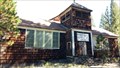
|   Tennant Elementary School - Tennant, CA Tennant Elementary School - Tennant, CA
in Former Schools This former school is now boarded up and on private property. posted by:  NW_history_buff NW_history_buff location: California date approved: 10/06/2015 last visited: never |
 view gallery view gallery S0.3 km S0.3 km
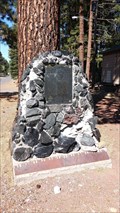
|  Tennant - Tennant, CA Tennant - Tennant, CA
in E Clampus Vitus Historical Markers This historical marker is located on the right of the road leading into the community of Tennant. posted by: NW_history_buff location: California date approved: 09/30/2015 last visited: never |
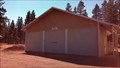 view gallery view galleryS0.3 km |  Tennant Vol. Fire Dept Tennant Vol. Fire Dept
in Firehouses This volunteer fire department resides in the community of Tennant, a former logging town. posted by: NW_history_buff location: California date approved: 10/05/2015 last visited: never |
 view gallery view gallery SW1.1 km SW1.1 km
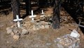
|  Tennant Pet Cemetery - Tennant, CA Tennant Pet Cemetery - Tennant, CA
in Pet Cemeteries This pet cemetery resides outside the main cemetery fenceline. posted by: NW_history_buff location: California date approved: 10/06/2015 last visited: never |
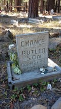 view gallery view gallerySW1.1 km |  Chance Butler - Tennant Cemetery - Tennant, CA Chance Butler - Tennant Cemetery - Tennant, CA
in Homemade Tombstones This homemade concrete headstone of an infant resides at Tennant Cemetery. posted by: NW_history_buff location: California date approved: 10/05/2015 last visited: never |
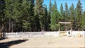 view gallery view gallerySW1.1 km |  Tennant Cemetery - Tennant, CA Tennant Cemetery - Tennant, CA
in Worldwide Cemeteries This cemetery resides just south of the community of Tennant, a former logging town. posted by: NW_history_buff location: California date approved: 10/06/2015 last visited: never |
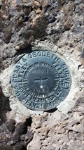
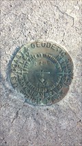
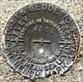
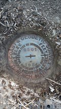 view gallery view gallerySW1.3 km |  MW0488 - USC&GS 'G 501' BM - Siskiyou County, CA MW0488 - USC&GS 'G 501' BM - Siskiyou County, CA
in U.S. Benchmarks This NGS disk is located in a rocky outcrop south of Tennant-Mt Hebron Rd. posted by: NW_history_buff location: California date approved: 10/04/2015 last visited: never |
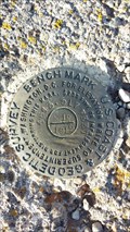
 view gallery view gallerySW1.6 km | USGS '49C 1931' BM - Siskiyou County, CA in U.S. Benchmarks This USGS disk is located north of Tennant-Mt Hebron Rd and just east of Antelope Creek. posted by: NW_history_buff location: California date approved: 10/04/2015 last visited: never |
 view gallery view gallery N2.3 km N2.3 km
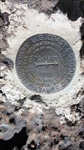
| MW0492 - USC&GS 'TENNANT RM 1' Reference Mark - Siskiyou County, CA in U.S. Benchmarks This NGS Reference Mark is located on top of a small hill of rocky outcrop just east of Tennant-Mt Hebron Rd. posted by: NW_history_buff location: California date approved: 10/04/2015 last visited: never |
 view gallery view galleryN2.4 km | MW0494 - USC&GS 'K 501' BM - Siskiyou County, CA in U.S. Benchmarks This NGS disk is located just west of Tennant-Mt Hebron Rd. posted by: NW_history_buff location: California date approved: 10/04/2015 last visited: never |
 view gallery view galleryN2.7 km | MW0495 - USCGS 'TENNANT AZ' Azimuth Mark - Siskiyou County, CA in U.S. Benchmarks This NGS mark is located in a rocky outcrop just east of Tennant-Mt Hebron Rd. posted by: NW_history_buff location: California date approved: 10/04/2015 last visited: never |
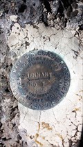
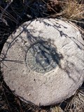
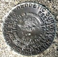
 view gallery view galleryN2.7 km |  MW0495 - USCGS 'TENNANT AZ' Azimuth Mark - Siskiyou County, CA MW0495 - USCGS 'TENNANT AZ' Azimuth Mark - Siskiyou County, CA
in Azimuth Benchmarks This NGS mark is located in a rocky outcrop just east of Tennant-Mt Hebron Rd and is part of the 'TENNANT' series of survey marks. posted by: NW_history_buff location: California date approved: 10/04/2015 last visited: never |
 view gallery view galleryN5 km | MW0497 - USC&GS 'M 501' BM - Siskiyou County, CA in U.S. Benchmarks This NGS disk is located just west of Tennant-Mt Hebron Rd. posted by: NW_history_buff location: California date approved: 10/04/2015 last visited: never |
 view gallery view gallery NW7.9 km NW7.9 km
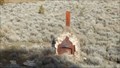
|  Bray Lonely Chimney - Siskiyou County, CA Bray Lonely Chimney - Siskiyou County, CA
in Lonely Chimneys This lonely chimney was spotted from Old State Hwy near the old community of Bray. posted by: NW_history_buff location: California date approved: 03/16/2015 last visited: never |
 view gallery view galleryNW8.4 km | MW0605 - USCGS 'B 496' BM - Bray, CA in U.S. Benchmarks This NGS benchmark is located just north of railroad tracks in the community of Bray, CA. posted by: NW_history_buff location: California date approved: 03/01/2015 last visited: never |
 view gallery view galleryNW8.5 km | MW0604 - USCGS 'N 19' BM - Bray, CA in U.S. Benchmarks This NGS benchmark resides just north of some railroad tracks in the community of Bray, CA. posted by: NW_history_buff location: California date approved: 03/01/2015 last visited: never |
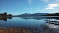
 view gallery view galleryNW10.8 km |  Orr Lake Boat Ramp - Siskiyou County, CA Orr Lake Boat Ramp - Siskiyou County, CA
in Boat Ramps This boat ramp is located on the east side of Orr Lake and within the day use area. posted by: NW_history_buff location: California date approved: 03/02/2015 last visited: never |
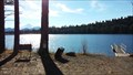
 view gallery view galleryNW10.8 km |  Orr Lake - Siskiyou County, CA Orr Lake - Siskiyou County, CA
in Natural Lakes This quiet little gem of a lake and campground are located north of Old State Hwy and the dead community of Bray, a former railroad town. posted by: NW_history_buff location: California date approved: 03/02/2015 last visited: never |
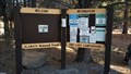
 view gallery view galleryNW10.8 km |  Orr Lake Trail - Siskiyou County, CA Orr Lake Trail - Siskiyou County, CA
in Hiking and walking trailheads This nicely maintained hiking trail is located at Orr Lake and contains a few campgrounds here as well. posted by: NW_history_buff location: California date approved: 03/02/2015 last visited: never |
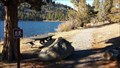
 view gallery view galleryNW11.3 km |  Orr Lake Campground - Siskiyou County, CA Orr Lake Campground - Siskiyou County, CA
in Campgrounds This quiet little lake contains a total of four campgrounds on the east side. posted by: NW_history_buff location: California date approved: 03/02/2015 last visited: never |
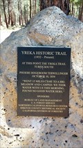 view gallery view galleryNW14.5 km |  Yreka Historic Trail - Siskiyou County, CA Yreka Historic Trail - Siskiyou County, CA
in Signs of History This historic trail passed through this area, and current roads including Tennant Rd, still follow the former trail in many parts. posted by: NW_history_buff location: California date approved: 10/06/2015 last visited: never |
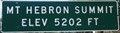 view gallery view galleryNW16.3 km |  U.S. Hwy. 97, California - Mt. Hebron Summit - Elevation 5202 U.S. Hwy. 97, California - Mt. Hebron Summit - Elevation 5202
in Elevation Signs Elevation sign at Mt Hebron Summit on U.S. Hwy. 97 in California. posted by: Volcanoguy location: California date approved: 11/08/2012 last visited: 09/22/2012 |
 view gallery view gallery E17.2 km E17.2 km
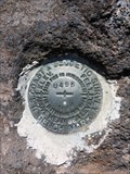
| MW0505 - USCGS J502 1954 - California in U.S. Benchmarks U.S. Coast and Geodetic Survey benchmark J502. posted by: Volcanoguy location: California date approved: 10/20/2017 last visited: 10/12/2016 |
 view gallery view galleryNW17.4 km | MX0046 - USC&GS 'U 495' BM - Siskiyou County, CA in U.S. Benchmarks An NGS benchmark located along railroad tracks in Siskiyou County. posted by: NW_history_buff location: California date approved: 06/03/2016 last visited: never |
 view gallery view galleryE18.3 km | MW0506 - USCGS K502 1954 - California in U.S. Benchmarks U.S. Coast and Geodetic Survey benchmark K502. posted by: Volcanoguy location: California date approved: 10/20/2017 last visited: 10/12/2016 |
|