 view gallery view gallery E18.8 km E18.8 km
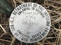
|   L 357 (PV0391) - Campbell County, Wyoming L 357 (PV0391) - Campbell County, Wyoming
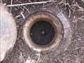
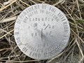
in U.S. Benchmarks A metal rod on the northwest side of State Highway 59. posted by:  Tom.dog Tom.dog location: Wyoming date approved: 05/02/2023 last visited: never |
 view gallery view gallery SE19.2 km SE19.2 km
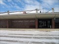
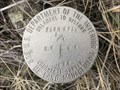
|  Gillette-Campbell County Airport Gillette-Campbell County Airport
in Airports Gillette, WY: Campbell County Airport posted by:  The Yoyo Man The Yoyo Man location: Wyoming date approved: 12/07/2008 last visited: 10/10/2022 |
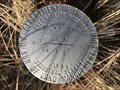
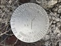
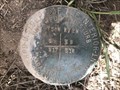
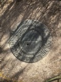 view gallery view gallerySE19.5 km |  PLANE AZ MK (PV0264) - Campbell County, Wyoming PLANE AZ MK (PV0264) - Campbell County, Wyoming
in Azimuth Benchmarks The azimuth mark for triangulation station PLANE, near the entrance to the Northeast Wyoming Regional Airport. posted by: Tom.dog location: Wyoming date approved: 07/02/2023 last visited: never |
 view gallery view gallerySE19.5 km | PLANE AZ MK (PV0264) - Campbell County, Wyoming in U.S. Benchmarks The azimuth mark for triangulation station PLANE, near the entrance to the Northeast Wyoming Regional Airport. posted by: Tom.dog location: Wyoming date approved: 01/08/2023 last visited: never |
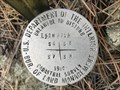
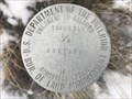
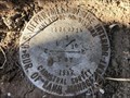
 view gallery view galleryE19.5 km |  T52N R72W S1 S12 R71W S6 S7 - Campbell County, Wyoming T52N R72W S1 S12 R71W S6 S7 - Campbell County, Wyoming
in Public Land Survey Marks A USDI-Bureau of Land Management section corner marker on BLM lands to the north of Gillette. posted by: Tom.dog location: Wyoming date approved: 12/23/2022 last visited: never |
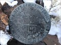
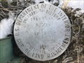
 view gallery view galleryE19.6 km | M 357 (PV0390) - Campbell County, Wyoming in U.S. Benchmarks A metal rod on the northwest side of State Highway 59. posted by: Tom.dog location: Wyoming date approved: 07/02/2023 last visited: never |
 view gallery view galleryE19.8 km | H 357 (PV0394) - Campbell County, Wyoming in U.S. Benchmarks A metal rod in the northeast quadrant of a dirt road's crossing over the railroad tracks. posted by: Tom.dog location: Wyoming date approved: 01/08/2023 last visited: never |
 view gallery view galleryE19.8 km | T52N R71W S6 S7 W 1/16 - Campbell County, Wyoming in Public Land Survey Marks A USDI-Bureau of Land Management sixteenth corner marker on BLM lands to the north of Gillette. posted by: Tom.dog location: Wyoming date approved: 12/23/2022 last visited: never |
![Image for T53N R71W S31 [T52N R71W S6] 1/4 SC - Campbell County, Wyoming](https://img.geocaching.com/waymarking/small/7c84c9b7-6975-4a2d-8b76-3f8ccd6ab2d7.jpg) view gallery view galleryE20.3 km | T53N R71W S31 [T52N R71W S6] 1/4 SC - Campbell County, Wyoming in Public Land Survey Marks This USDI-Bureau of Land Management standard quarter corner marker is located on the southeast side of State Highway 59. posted by: Tom.dog location: Wyoming date approved: 02/05/2023 last visited: never |
![Image for [T53N R71W S31] T52N R71W S6 1/4 CC](https://img.geocaching.com/waymarking/small/1bdd0a95-1cca-4715-80e6-88a5d7ac0134.jpg) view gallery view galleryE20.6 km | [T53N R71W S31] T52N R71W S6 1/4 CC in Public Land Survey Marks This USDI-Bureau of Land Management closing quarter corner marker is in the Burnt Hollow Special Recreation Management Area. posted by: Tom.dog location: Wyoming date approved: 02/18/2023 last visited: never |
![Image for T53N R71W S31 [T52N R71W S6] E 1/16 SC - Campbell County, Wyoming](https://img.geocaching.com/waymarking/small/1681682a-cdd7-43ae-a9c9-c7253c4849b2.jpg) view gallery view galleryE20.6 km | T53N R71W S31 [T52N R71W S6] E 1/16 SC - Campbell County, Wyoming in Public Land Survey Marks A USDI-Bureau of Land Management standard sixteenth corner marker in the Burnt Hollow Special Recreation Management Area. posted by: Tom.dog location: Wyoming date approved: 02/18/2023 last visited: never |
 view gallery view galleryE21.1 km | T52N R71W S6 S5 S8 S7 - Campbell County, Wyoming in Public Land Survey Marks This USDI-Bureau of Land Management section corner marker is in the Burnt Hollow Special Recreation Management Area. posted by: Tom.dog location: Wyoming date approved: 04/17/2023 last visited: never |
![Image for T53N R71W S31 S32 [T52N R71W S6] SC - Campbell County, Wyoming](https://img.geocaching.com/waymarking/small/2fd77711-afd1-4f20-bf75-b297008d19ff.jpg) view gallery view galleryE21.1 km | T53N R71W S31 S32 [T52N R71W S6] SC - Campbell County, Wyoming in Public Land Survey Marks This USDI-Bureau of Land Management standard corner marker is in the Burnt Hollow Special Recreation Management Area. posted by: Tom.dog location: Wyoming date approved: 02/18/2023 last visited: never |
 view gallery view galleryE21.1 km | T52N R71W S6 S5 S 1/16 - Campbell County, Wyoming in Public Land Survey Marks A USDI-Bureau of Land Management sixteenth corner marker in the Burnt Hollow Special Recreation Management Area. posted by: Tom.dog location: Wyoming date approved: 04/17/2023 last visited: never |
 view gallery view galleryE21.1 km | T53N R71W S31 S32 S 1/16 - Campbell County, Wyoming in Public Land Survey Marks This USDI-Bureau of Land Management sixteenth corner marker is located in the Burnt Hollow Special Recreation Management Area. posted by: Tom.dog location: Wyoming date approved: 02/05/2023 last visited: never |
 view gallery view galleryE21.2 km | T52N R71W S6 S5 1/4 - Campbell County, Wyoming in Public Land Survey Marks This USDI-Bureau of Land Management quarter corner marker is in the Burnt Hollow Special Recreation Management Area. posted by: Tom.dog location: Wyoming date approved: 04/17/2023 last visited: never |
 view gallery view galleryE21.2 km | T53N R71W S31 S32 1/4 - Campbell County, Wyoming in Public Land Survey Marks A USDI-Bureau of Land Management quarter corner marker in the Burnt Hollow Special Recreation Management Area. posted by: Tom.dog location: Wyoming date approved: 02/18/2023 last visited: never |
 view gallery view galleryE21.2 km | T52N R71W S6 S5 N 1/16 - Campbell County, Wyoming in Public Land Survey Marks A USDI-Bureau of Land Management sixteenth corner marker in the Burnt Hollow Special Recreation Management Area. posted by: Tom.dog location: Wyoming date approved: 04/17/2023 last visited: never |
 view gallery view galleryE21.2 km | T53N R71W S31 S32 N 1/16 - Campbell County, Wyoming in Public Land Survey Marks This USDI-Bureau of Land Management sixteenth corner marker is in the Burnt Hollow Special Recreation Management Area. posted by: Tom.dog location: Wyoming date approved: 02/18/2023 last visited: never |
![Image for [T53N R71W S32] T52N R71W S6 S5 CC - Campbell County, Wyoming](https://img.geocaching.com/waymarking/small/cc8022a9-81d0-4321-b714-335c8eb7b920.jpg) view gallery view galleryE21.4 km | [T53N R71W S32] T52N R71W S6 S5 CC - Campbell County, Wyoming in Public Land Survey Marks A USDI-Bureau of Land Management closing corner marker in the Burnt Hollow Special Recreation Management Area. posted by: Tom.dog location: Wyoming date approved: 02/05/2023 last visited: never |
![Image for T53N R71W S32 [T52N R71W S5] W 1/16 SC - Campbell County, Wyoming](https://img.geocaching.com/waymarking/small/4c14c696-ef3e-42ca-b03c-d0c188b2d757.jpg) view gallery view galleryE21.4 km | T53N R71W S32 [T52N R71W S5] W 1/16 SC - Campbell County, Wyoming in Public Land Survey Marks This USDI-Bureau of Land Management standard sixteenth corner marker is in the Burnt Hollow Special Recreation Management Area. posted by: Tom.dog location: Wyoming date approved: 02/05/2023 last visited: never |
 view gallery view galleryE21.4 km | T52N R71W S5 S8 W 1/16 - Campbell County, Wyoming in Public Land Survey Marks A USDI-Bureau of Land Management sixteenth corner marker in the Burnt Hollow Special Recreation Management Area. posted by: Tom.dog location: Wyoming date approved: 04/17/2023 last visited: never |
 view gallery view gallerySE21.6 km | T50N R72W S8 S9 S16 S17 - Campbell County, Wyoming in Public Land Survey Marks USDI-Bureau of Land Management section corner marker on the south side of Ratcliff Drive to the north of Gillette. posted by: Tom.dog location: Wyoming date approved: 05/08/2023 last visited: never |
 view gallery view galleryE21.6 km | T53N R71W S32 W 1/16 - Campbell County, Wyoming in Public Land Survey Marks This USDI-Bureau of Land Management sixteenth corner marker is in the Burnt Hollow Special Recreation Management Area. posted by: Tom.dog location: Wyoming date approved: 02/05/2023 last visited: never |
![Image for T53N R71W S32 [T52N R71W S5] 1/4 SC - Campbell County, Wyoming](https://img.geocaching.com/waymarking/small/b351fb58-6987-417a-9739-c2cd856e471b.jpg) view gallery view galleryE21.7 km | T53N R71W S32 [T52N R71W S5] 1/4 SC - Campbell County, Wyoming in Public Land Survey Marks A USDI-Bureau of Land Management standard quarter corner marker in the Burnt Hollow Special Recreation Management Area. posted by: Tom.dog location: Wyoming date approved: 02/05/2023 last visited: never |
|