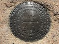
 view gallery view gallery N13 km N13 km
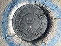
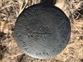
|   N 101 (MP0057) - Albany County, Wyoming N 101 (MP0057) - Albany County, Wyoming
in U.S. Benchmarks This benchmark is located on the north side of the now-abandoned railway bed of the Coalmont Branch of the Union Pacific Railroad. posted by:  Tom.dog Tom.dog location: Wyoming date approved: 11/21/2022 last visited: never |
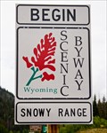 view gallery view galleryN14.3 km |  Snowy Range Scenic Byway - Centennial, WY Snowy Range Scenic Byway - Centennial, WY
in National Scenic Byways This 29 mile scenic byway cuts through the Medicine Bow National Forest from Laramie to the Upper Platte River Valley. posted by: IJAdventures location: Wyoming date approved: 09/11/2013 last visited: 07/24/2016 |
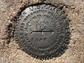
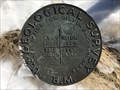
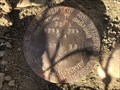
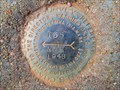
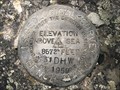 view gallery view galleryN15 km | 31 DHW - Albany County, Wyoming in U.S. Benchmarks This USGS benchmark is located near the intersection of State Highway 130 and Barber Lake Road. posted by: Tom.dog location: Wyoming date approved: 07/31/2023 last visited: never |
 view gallery view gallery E16.6 km E16.6 km
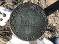
| 144 NO 2 - Albany County, Wyoming in U.S. Benchmarks Reference mark 2 for destroyed secondary triangulation station 144. posted by: Tom.dog location: Wyoming date approved: 01/08/2023 last visited: never |
 view gallery view galleryE16.6 km | 144 NO 1 - Albany County, Wyoming in U.S. Benchmarks Reference mark 1 for destroyed secondary triangulation station 144. posted by: Tom.dog location: Wyoming date approved: 01/08/2023 last visited: never |
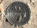
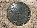
 view gallery view galleryE17.2 km |  144 Azimuth Mark - Albany County, Wyoming 144 Azimuth Mark - Albany County, Wyoming
in Azimuth Benchmarks The azimuth mark for destroyed secondary triangulation station 144 (MO1280). posted by: Tom.dog location: Wyoming date approved: 07/02/2023 last visited: never |
 view gallery view galleryE17.2 km | 144 Azimuth Mark - Albany County, Wyoming in U.S. Benchmarks The azimuth mark for destroyed secondary triangulation station 144. posted by: Tom.dog location: Wyoming date approved: 01/08/2023 last visited: never |
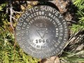
 view gallery view galleryE17.5 km | 7366 LARAMIE NO 8 - Albany County, Wyoming in U.S. Benchmarks A USGS pipe cap on the northwest side of State Highway 230. posted by: Tom.dog location: Wyoming date approved: 01/08/2023 last visited: never |
 view gallery view gallery SE21.4 km SE21.4 km
| M 79 (MO0684) - Albany County, Wyoming in U.S. Benchmarks This benchmark can be found on the southeast side of State Highway 10. posted by: Tom.dog location: Wyoming date approved: 07/31/2023 last visited: never |
 view gallery view galleryE22.2 km | 7313 LARAMIE NO 7 - Albany County, Wyoming in U.S. Benchmarks A USGS pipe cap on the southeast side of State Highway 230. posted by: Tom.dog location: Wyoming date approved: 01/08/2023 last visited: never |
 view gallery view gallery NW22.4 km NW22.4 km
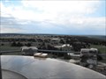
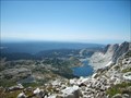
|  Snowy Range Vista at Libby Flats - Medicine Bow National Forest, WY Snowy Range Vista at Libby Flats - Medicine Bow National Forest, WY
in Scenic Overlooks A parking area complete with a view of Brown, Snowy and Sugar Loaf to one direction and Libby Flats and Colorado to the other. A little closer are some high alpine lakes and on the other side of the close ridge, Lake Marie and Mirror Lake. posted by: Eagle1977 location: Wyoming date approved: 01/12/2013 last visited: never |
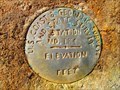
 view gallery view gallerySE22.7 km | K 79 (MO0683) - Albany County, Wyoming in U.S. Benchmarks A benchmark on the southeast side of Gyp Quarry Road. posted by: Tom.dog location: Wyoming date approved: 07/31/2023 last visited: never |
 view gallery view galleryNW22.7 km |  Snowy Range/Medicine Bow - United Airlines 409 Snowy Range/Medicine Bow - United Airlines 409
in Plane Crash Sites Historical marker commemorating the crash of United Airlines Flight 409. posted by: Eagle1977 location: Wyoming date approved: 10/09/2012 last visited: 09/09/2013 |
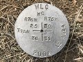 view gallery view galleryE22.9 km |  T15N R76W S25 S36 R75W S30 S31 WC - Albany County, Wyoming T15N R76W S25 S36 R75W S30 S31 WC - Albany County, Wyoming
in Public Land Survey Marks A WLC witness corner marker in the Twin Buttes Public Access Area. posted by: Tom.dog location: Wyoming date approved: 02/18/2023 last visited: never |
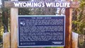 view gallery view galleryNW23.3 km |  The Snowy Range - Medicine Bow National Forest, WY The Snowy Range - Medicine Bow National Forest, WY
in Flora and Fauna Information Signs Lodgepole pine, quaking aspen, alpine tundra, wildflowers, pika, ptarmigan, elk and trout are some of the wildlife and flora you may find in the Snowy Range and read about on this sign. posted by: IJAdventures location: Wyoming date approved: 08/29/2013 last visited: never |
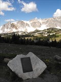
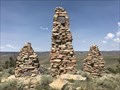 view gallery view gallerySE23.8 km |  Dan Birkholz Cairns - Albany County, Wyoming Dan Birkholz Cairns - Albany County, Wyoming
in Cairns A series of three cairns built in memory of Dan Birkholz, located on the western slope of Red Mountain. posted by: Tom.dog location: Wyoming date approved: 08/04/2023 last visited: never |
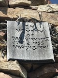 view gallery view gallerySE23.8 km |  Dan Birkholz - Albany County, Wyoming Dan Birkholz - Albany County, Wyoming
in Citizen Memorials This memorial cairn is dedicated to Dan Birkholz, and is located on the western slope of Red Mountain. posted by: Tom.dog location: Wyoming date approved: 07/31/2023 last visited: never |
 view gallery view galleryE24 km | T15N R75W S30 S31 E 1/16 - Albany County, Wyoming in Public Land Survey Marks This Wyoming Game & Fish Commission sixteenth corner marker is located on the south side of the Twin Buttes Public Access Area. posted by: Tom.dog location: Wyoming date approved: 12/23/2022 last visited: never |
 view gallery view gallery NE24.9 km NE24.9 km
| T15N R76W S12 R75W S7 1/4 - Albany County, Wyoming in Public Land Survey Marks A USDI-Bureau of Land Management quarter corner marker on the west side of Big Hollow Road. posted by: Tom.dog location: Wyoming date approved: 12/23/2022 last visited: never |
 view gallery view galleryNW24.9 km |  Medicine Bow Peak, Snowy Range - Wyoming Medicine Bow Peak, Snowy Range - Wyoming
in Mountain Summits The defining peak of the Laramie Valley, Medicine Bow is visible from Veedauwoo Pass on I-25, and as far north as Bosler on a clear day. posted by: Eagle1977 location: Wyoming date approved: 10/09/2012 last visited: never |
 view gallery view galleryE26.4 km | 7276 LARAMIE NO 6 - Albany County, Wyoming in U.S. Benchmarks A USGS pipe cap on the northwest side of State Highway 230. posted by: Tom.dog location: Wyoming date approved: 01/08/2023 last visited: never |
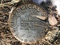
 view gallery view gallerySE26.7 km | RED NO 1 - Larimer County, Colorado in U.S. Benchmarks Reference mark 1 for triangulation station RED (LL1395). posted by: Tom.dog location: Colorado date approved: 07/31/2023 last visited: never |
 view gallery view gallerySE26.7 km | RED (LL1395) - Larimer County, Colorado in U.S. Benchmarks A triangulation station on the summit of Red Mountain, just south of the Wyoming-Colorado border. posted by: Tom.dog location: Colorado date approved: 07/31/2023 last visited: never |
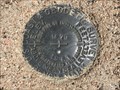
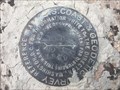
 view gallery view galleryE30.4 km | STATION NO. 134 - Albany County, Wyoming in U.S. Benchmarks A severely damaged U.S. Coast & Geodetic Survey and State Survey disk that serves as the azimuth mark for benchmark 135 (MO1273). posted by: Tom.dog location: Wyoming date approved: 11/21/2022 last visited: never |
 view gallery view galleryE30.7 km | 135 NO 2 - Albany County, Wyoming in U.S. Benchmarks Reference mark 2 for U.S. Coast & Geodetic Survey and State Survey station number 135 (MO1273). posted by: Tom.dog location: Wyoming date approved: 11/21/2022 last visited: never |
|