 view gallery view gallery NE1.3 km NE1.3 km
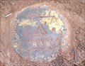
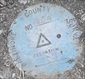
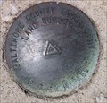
|   Baltimore County Survey Control GIS-197 Baltimore County Survey Control GIS-197
in U.S. Benchmarks A Baltimore County, Maryland, Survey Control brass disk, undocumented on geocaching.com and undocumented on the NGS database, west of Randallstown, Maryland and south of Liberty Road (Maryland route 26) posted by:  NCPositronics NCPositronics location: Maryland date approved: 06/17/2019 last visited: 06/22/2019 |
 view gallery view gallery NW1.4 km NW1.4 km
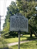
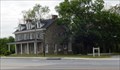
|  Randallstown, MD - New Tavern Randallstown, MD - New Tavern
in Maryland Historical Markers An historical marker along Maryland Route 26 commemorating the New Tavern, built in 1802 posted by: NCPositronics location: Maryland date approved: 07/15/2019 last visited: 08/20/2021 |
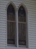 view gallery view galleryNE1.6 km |  Mt. Paran Presbyterian Church - Randallstown, MD Mt. Paran Presbyterian Church - Randallstown, MD
in Stained Glass Windows Mt. Paran Presbyterian Church has two stained glass windows over the front door of the church. posted by:  Don.Morfe Don.Morfe location: Maryland date approved: 01/15/2023 last visited: 01/16/2023 |
 view gallery view galleryNE1.6 km | Mt. Paran Presbyterian Church and Cemetery-Randallstown, MD in Maryland Historical Markers Mt. Paran Church was incorporated September 18, 1841. The church was called Soldier's Delight prior to 1841. posted by: Don.Morfe location: Maryland date approved: 08/08/2019 last visited: 09/18/2021 |
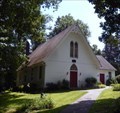 view gallery view galleryNE1.6 km |  Mt. Paran Presbyterian Church - Randallstown, MD Mt. Paran Presbyterian Church - Randallstown, MD
in This Old Church The original church was renovated in 1882. It was rebuilt using the original log walls, increasing its height, length, and erecting its present steep roof. posted by: Don.Morfe location: Maryland date approved: 01/15/2023 last visited: 01/16/2023 |
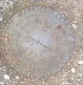
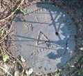
 view gallery view gallery SE1.9 km SE1.9 km
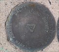
| Baltimore Co. Survey Control No. GIS-154 - Randallstown, MD in U.S. Benchmarks A brass disk, undocumented on geocaching.com or the NGS database, northwest of Randallstown. posted by: NCPositronics location: Maryland date approved: 08/07/2020 last visited: 08/14/2020 |
 view gallery view gallery E2.9 km E2.9 km
| Holy Family Catholic Church - Randallstown MD in Roman Catholic Churches The Holy Family Parish in Randallstown has been in existence for 143 years. posted by: Don.Morfe location: Maryland date approved: 05/29/2021 last visited: 09/03/2021 |
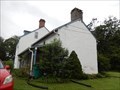
 view gallery view galleryE3.2 km |  Choate House (Randallstown, Maryland) Choate House (Randallstown, Maryland)
in Wikipedia Entries Choate House is a historic home located at Randallstown, Baltimore County, Maryland. It is a 2+1/2-story gable-roofed stone building built in 1810, with a porch and dormers added in the 1880s. posted by: Don.Morfe location: Maryland date approved: 05/09/2021 last visited: 09/07/2021 |
 view gallery view galleryE3.2 km | Randallstown, Maryland in Wikipedia Entries Randallstown is an unincorporated community and census-designated place in Baltimore County, Maryland. The GPS Coordinates are for the Choate House in Randallstown MD. It is located at 9600 Liberty Road, Randallstown, MD 21133. posted by: Don.Morfe location: Maryland date approved: 12/08/2023 last visited: 05/16/2021 |
 view gallery view galleryE3.2 km |  Choate House - Randallstown MD Choate House - Randallstown MD
in U.S. National Register of Historic Places Choate House is an important example of rural nineteenth and early twentieth century domestic architecture of southwestern Baltimore County. Throughout the nineteenth century and the first quarter of the twentieth century this area remained rural. posted by: Don.Morfe location: Maryland date approved: 05/10/2021 last visited: 09/07/2021 |
 view gallery view galleryE3.2 km |  Bell Tower Holy Family Catholic Church - Randallstown MD Bell Tower Holy Family Catholic Church - Randallstown MD
in Bell Towers The bell tower is near the entrance to Holy Family Catholic Church. posted by: Don.Morfe location: Maryland date approved: 05/28/2021 last visited: 09/03/2021 |
 view gallery view galleryE3.5 km | Baltimore County Survey Control CBM877 in U.S. Benchmarks A Baltimore County, Maryland survey marker, undocumented on either geocaching.com or the NGS web site, near Randallstown, Maryland. posted by: NCPositronics location: Maryland date approved: 07/09/2019 last visited: 07/13/2019 |
 view gallery view galleryNE3.5 km | ") Soldiers Delight Mine Soldiers Delight Mine
in Cave Entrances (Artificial) Soldiers Delight Serpentine Barrens is located in the Soldiers Delight Natural Environmental Area (NEA) in western Baltimore County. posted by: flyingmoose location: Maryland date approved: 02/20/2008 last visited: 02/07/2022 |
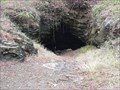 view gallery view galleryNE3.5 km |  Soldiers Delight Mine Soldiers Delight Mine
in Mines This mine is no longer active but is a brisk walk from the roadside parking. posted by: flyingmoose location: Maryland date approved: 04/01/2008 last visited: 06/10/2010 |
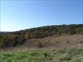 view gallery view gallery N3.7 km N3.7 km
| Soldiers Delight in Maryland Historical Markers Located at the parking area in the middle of the Soldiers Delight park. The trails are great and well worth the walk to see the largest Serpentine Barren in the US. posted by: flyingmoose location: Maryland date approved: 10/16/2006 last visited: 06/16/2019 |
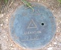
 view gallery view galleryN3.9 km | USCGS CROSS RM 1 in U.S. Benchmarks This benchmark is undocumented on geocaching.com and undocumented on the NGS database. It is a United States Coast and Geodetic Survey brass disk located in Soldiers Delight Natural Environment Area, west of Randallstown, Baltimore County, MD. posted by: NCPositronics location: Maryland date approved: 06/16/2019 last visited: 11/03/2019 |
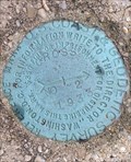 view gallery view galleryN3.9 km | USCGS CROSS RM 2 in U.S. Benchmarks This benchmark is undocumented on geocaching.com and undocumented on the NGS database. It is a United States Coast and Geodetic Survey brass disk, a reference mark for NGS and geocaching.com JV6027, designation CROSS. It is reference mark 2. posted by: NCPositronics location: Maryland date approved: 06/17/2019 last visited: 11/03/2019 |
 view gallery view galleryN3.9 km | USCGS CROSS RM 3 in U.S. Benchmarks This benchmark is undocumented on geocaching.com and undocumented on the NGS database. It is a United States Coast and Geodetic Survey brass disk, a reference mark for USGS and geocaching.com JV6027, designation CROSS. It is reference mark 3. posted by: NCPositronics location: Maryland date approved: 06/16/2019 last visited: 11/03/2019 |
 view gallery view galleryNE3.9 km | Baltimore County Survey Control No. 198 in U.S. Benchmarks A Baltimore County Survey Control in Owings Mills, not documented on geocaching.com or the NGS database, and documented on the Baltimore County web site as GIS-198. posted by: NCPositronics location: Maryland date approved: 07/09/2019 last visited: 07/13/2019 |
 view gallery view gallery W4 km W4 km
| Branton Manor - Sykesville MD in Wikipedia Entries Branton Manor is a historic home located at Sykesville, Carroll County, Maryland, United States. It is two stories with a gable roof and a large stone interior chimney at the east end. posted by: Don.Morfe location: Maryland date approved: 08/31/2021 last visited: 09/04/2021 |
 view gallery view galleryW4 km | Branton Manor - Sykesville MD in U.S. National Register of Historic Places Branton Manor is interesting for its odd combination of three architectural styles and for some of the features of its different structures. posted by: Don.Morfe location: Maryland date approved: 09/01/2021 last visited: 09/04/2021 |
 view gallery view galleryE4.2 km | Baltimore County Survey Control CBM880 in U.S. Benchmarks A Baltimore County, Maryland survey marker, undocumented on either geocaching.com or the NGS web site, near Randallstown, Maryland. Mark is minimally documented on the Baltimore County web site as CBM880. posted by: NCPositronics location: Maryland date approved: 07/16/2019 last visited: 07/20/2019 |
 view gallery view galleryE4.3 km | Baltimore County Survey Control GIS-153 in U.S. Benchmarks A brass disk on the south side of Winands Road, west of Randallstown High School and approximately 18 inches south of the sidewalk. posted by: NCPositronics location: Maryland date approved: 06/16/2019 last visited: 06/22/2019 |
 view gallery view gallery S4.3 km S4.3 km
|  Granite Missionary Baptist Church - Granite MD Granite Missionary Baptist Church - Granite MD
in Churchyard Cemeteries Granite Missionary Baptist Church, former St. Paul's Methodist Church, was built in 1878. On the grounds of the church is a cemetery. posted by: Don.Morfe location: Maryland date approved: 06/02/2021 last visited: 09/03/2021 |
 view gallery view galleryS4.3 km |  Granite Missionary Baptist Church-Granite Historic District - Granite MD Granite Missionary Baptist Church-Granite Historic District - Granite MD
in NRHP Historic Districts - Contributing Buildings The Granite Historic District is significant for its association with the granite quarrying industry in western Baltimore County in the nineteenth and early twentieth century. Included in the district is Granite Missionary Baptist Church. posted by: Don.Morfe location: Maryland date approved: 05/30/2021 last visited: 09/03/2021 |
|