 view gallery view gallery SE2.3 km SE2.3 km
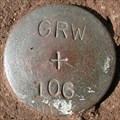
|   GRW 106, Lexington, KY GRW 106, Lexington, KY
in U.S. Benchmarks East of Old Richmond Rd. posted by:  wuja wuja location: Kentucky date approved: 03/17/2007 last visited: never |
 view gallery view gallery N2.9 km N2.9 km
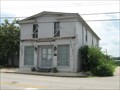
|  Rose's Store - Athens, KY Rose's Store - Athens, KY
in NRHP Historic Districts - Contributing Buildings Simple commercial building dating from the mid-19th century. posted by:  vhasler vhasler location: Kentucky date approved: 06/29/2009 last visited: never |
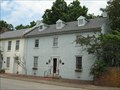 view gallery view galleryN2.9 km | Marshall Tavern - Athens, KY in NRHP Historic Districts - Contributing Buildings Marshall Tavern was constructed ca. 1840 as an addition to an inn that stands next door. It now a private residence. posted by: vhasler location: Kentucky date approved: 06/29/2009 last visited: never |
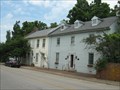
 view gallery view galleryN2.9 km |  Athens Historic District - KY Athens Historic District - KY
in U.S. National Register of Historic Places Most of Athens (said locally with a long "A" sound) was destroyed by fire over 150 years ago, but a few buildings still remain in this very small rural town. posted by: vhasler location: Kentucky date approved: 06/29/2009 last visited: never |
 view gallery view galleryN2.9 km |  Athens, KY Athens, KY
in Small Town, Big Name Athens, Kentucky (said locally with a long "A" sound) is not at all like its namesake Athens, Greece. posted by: vhasler location: Kentucky date approved: 06/29/2009 last visited: never |
 view gallery view galleryN2.9 km | Brick Row House - Athens, KY in NRHP Historic Districts - Contributing Buildings Building #3 in the NRHP application is a non-descript row house. posted by: vhasler location: Kentucky date approved: 06/30/2009 last visited: never |
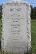
 view gallery view galleryN3.1 km |  Samuel Boone - Lexington, KY Samuel Boone - Lexington, KY
in American Revolutionary War Veteran Graves Marker is on Gentry Road just east of North Baxter Boulevard, on the left when traveling east. Marker is at Boone's Station State Historic Site. Public access into the site is restricted, with no-trespassing posted. posted by: Crazy4horses location: Kentucky date approved: 04/17/2023 last visited: never |
 view gallery view galleryN3.1 km |  Samuel Boone - Lexington, KY, USA Samuel Boone - Lexington, KY, USA
in Daughters of the American Revolution Marker is on Gentry Road just east of North Baxter Boulevard, on the left when traveling east. Marker is at Boone's Station State Historic Site. Public access into the site is restricted, with no-trespassing posted. posted by: Crazy4horses location: Kentucky date approved: 06/01/2023 last visited: never |
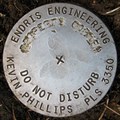 view gallery view galleryN4.2 km | Endris at Athens Boonesboro Road, Lexington, KY in U.S. Benchmarks North of Athens Boonesboro Rd. posted by: wuja location: Kentucky date approved: 03/24/2007 last visited: 06/14/2008 |
 view gallery view gallery SW4.5 km SW4.5 km
|  Moore Spring - Fayette County, KY, US Moore Spring - Fayette County, KY, US
in Natural Springs Located in Raven Run Nature Sanctuary in Lexington, Kentucky posted by: Crazy4horses location: Kentucky date approved: 12/28/2016 last visited: 12/28/2016 |
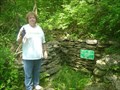
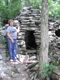 view gallery view gallerySW4.5 km |  Raven Run Lime Kiln - Fayette County, KY, US Raven Run Lime Kiln - Fayette County, KY, US
in Ovens and Kilns Located in the Raven Run Nature Sanctuary. posted by: Crazy4horses location: Kentucky date approved: 01/03/2017 last visited: 01/21/2017 |
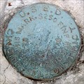 view gallery view gallerySE4.8 km | U.S.E.D. at Old Clay’s Ferry Bridge, Lexington, KY in U.S. Benchmarks US Engineer Department, Cincinnati District RP (Reference Point?) disk. posted by: wuja location: Kentucky date approved: 04/19/2007 last visited: never |
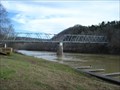 view gallery view gallerySE4.8 km |  Old Clay's Ferry Bridge - Lexington, KY Old Clay's Ferry Bridge - Lexington, KY
in Truss Bridges Old Clay's Ferry Bridge, also known as the KY 2328 bridge, crosses over the Kentucky River near Lexington, Kentucky, USA. posted by: Marine Biologist location: Kentucky date approved: 01/02/2009 last visited: 06/05/2010 |
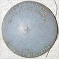
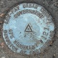
 view gallery view gallerySW4.8 km | Az for Mon 0001 in U.S. Benchmarks Lex-Fay Urban County Government Division of Engineering Azimuth for 01
AZI for GZ3069 posted by: khaytsus location: Kentucky date approved: 07/06/2008 last visited: never |
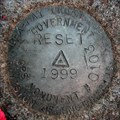
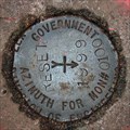
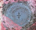 view gallery view gallerySW5.3 km | Az for Mon 0001 1999 Reset in U.S. Benchmarks Lex-Fay Urban County Government Division of Engineering
Azimuth for 0001 Reset 1999 posted by: khaytsus location: Kentucky date approved: 07/06/2008 last visited: never |
 view gallery view gallerySE5.5 km | Endris at Clays Ferry Bridge, Madison County, KY in U.S. Benchmarks On the southwest wingwall of the southeast abutment of I-75 bridge over Kentucky River. About 6 feet south from NGS mark I75 L 85 RESET, AD9230. posted by: wuja location: Kentucky date approved: 07/28/2007 last visited: never |
 view gallery view gallery NW5.6 km NW5.6 km
| LFUCG GPS STA 0103 RESET 1999, Fayette County, KY in U.S. Benchmarks Northeast of Athens-Boonesboro Rd and about 0.63 mi from its intersection with I-75. Reset of LFUCG GPS STA 0103 (GZ3102) which was apparently lost during I-75 ramp widening. posted by: wuja location: Kentucky date approved: 01/02/2008 last visited: never |
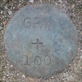 view gallery view galleryNW6.3 km | GRW 100, Lexington, KY in U.S. Benchmarks Just 6 feet east of LFUCG GPS STA 0104. posted by: wuja location: Kentucky date approved: 03/09/2007 last visited: never |
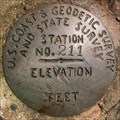 view gallery view galleryNW6.9 km | USCGS&SS 211, Lexington, KY in U.S. Benchmarks Placed in 1934 as part of the Civil Works Administration program to keep surveyors employed. posted by: wuja location: Kentucky date approved: 05/12/2007 last visited: never |
 view gallery view galleryN7.6 km | LFUCG GPS STA 0100-2, Lexington, KY in U.S. Benchmarks East of Cleveland Rd. posted by: wuja location: Kentucky date approved: 04/17/2007 last visited: never |
 view gallery view galleryNW7.7 km | LFUCG GPS STA 0121, Lexington, KY in U.S. Benchmarks About 15 feet south from the centerline of Walnut Hill-Chilesburg Road. posted by: wuja location: Kentucky date approved: 02/23/2007 last visited: never |
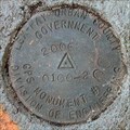
 view gallery view galleryN7.7 km | 0100 AZI RESET 1999, Lexington, KY in U.S. Benchmarks East of Cleveland Rd. posted by: wuja location: Kentucky date approved: 04/17/2007 last visited: never |
 view gallery view gallery W7.7 km W7.7 km
| GRW 82, Lexington, KY in U.S. Benchmarks Monumented by GRW, most likely in 1977. posted by: wuja location: Kentucky date approved: 02/24/2007 last visited: never |
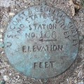 view gallery view galleryNW8 km | USCGS&SS 106, Lexington, KY in U.S. Benchmarks Shown as a horizontal control station BM 1047 on the Coletown, KY 7.5' topo quad. posted by: wuja location: Kentucky date approved: 02/23/2007 last visited: never |
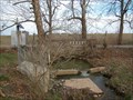 view gallery view galleryNW8 km |  East Hickman Creek Tributary at Chilesburg Rd, Lexington,KY East Hickman Creek Tributary at Chilesburg Rd, Lexington,KY
in River Gauges USGS Gauge 03284525
posted by: wuja location: Kentucky date approved: 03/22/2007 last visited: never |
|