 view gallery view gallery S0.6 km S0.6 km
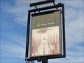
|   Kirklands Hotel , 605 Leeds Road - Outwood, UK Kirklands Hotel , 605 Leeds Road - Outwood, UK
in Pictorial Pub Signs This slightly faded sign shows a photo of two rows of copper boilers. posted by:  dtrebilc dtrebilc location: Yorkshire, United Kingdom date approved: 10/30/2022 last visited: never |
 view gallery view gallery W0.6 km W0.6 km
|  Lofthouse Colliery Disaster - Lofthouse, UK Lofthouse Colliery Disaster - Lofthouse, UK
in Disaster Memorials This memorial obelisk and information board commemorate a disaster at the coal mine when the workings suddenly flooded. posted by: dtrebilc location: Yorkshire, United Kingdom date approved: 01/20/2023 last visited: never |
 view gallery view gallery N0.8 km N0.8 km
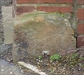
|  Milestone - Leeds Road, Lofthouse, Wakefield, Yorkshire, UK. Milestone - Leeds Road, Lofthouse, Wakefield, Yorkshire, UK.
in Milestones This milestone has become integrated with a low wall and would be easily passed by. posted by:  HitchinLookers HitchinLookers location: Yorkshire, United Kingdom date approved: 02/06/2012 last visited: 02/06/2012 |
 view gallery view galleryS0.8 km | Milestone - Leeds Road, Outwood, Wakefield, Yorkshire, UK. in Milestones This milestone, whilst left undisturbed could do with a lick of paint. posted by: HitchinLookers location: Yorkshire, United Kingdom date approved: 02/05/2012 last visited: never |
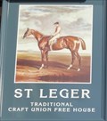 view gallery view galleryS1 km | The St. Leger, 547 Leeds Road - Outwood, UK in Pictorial Pub Signs This pub sign is a painting of a jockey sitting on a race horse. posted by: dtrebilc location: Yorkshire, United Kingdom date approved: 10/30/2022 last visited: never |
 view gallery view galleryN1 km | The Castle, 162 Leeds Rd - Lofthouse, UK in Pictorial Pub Signs This pub sign shows a picture of a heavily defended castle. posted by: dtrebilc location: Yorkshire, United Kingdom date approved: 10/30/2022 last visited: never |
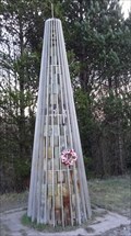
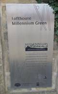 view gallery view galleryN1.3 km |  Millennium Green - Lofthouse, UK Millennium Green - Lofthouse, UK
in Made for the Millennium This Millennium Green is one of 245 Millennium Greens created across the UK to celebrate the Millennium. posted by: dtrebilc location: Yorkshire, United Kingdom date approved: 10/28/2022 last visited: never |
 view gallery view gallery E1.4 km E1.4 km
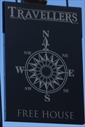
| The Travellers Inn 12 Lake Lock Road - Stanley, UK in Pictorial Pub Signs This pub sign shows a compass rose with all relevant directions marked. posted by: dtrebilc location: Yorkshire, United Kingdom date approved: 01/31/2023 last visited: never |
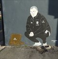 view gallery view galleryE1.4 km |  Marcelo Bielsa - Stanley, UK Marcelo Bielsa - Stanley, UK
in Murals This mural is a portrait of Marcelo Bielsa who at the time was the popular manager of Leeds United Football Club. posted by: dtrebilc location: Yorkshire, United Kingdom date approved: 02/12/2023 last visited: never |
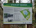
 view gallery view gallery SE1.8 km SE1.8 km
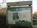
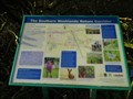
|  Stanley Marsh Local Nature Reserve - Stanley, UK Stanley Marsh Local Nature Reserve - Stanley, UK
in Flora and Fauna Information Signs This sign is in the car park of a Local Nature Reserve, an area that used to be the site of a coal mine. posted by: dtrebilc location: Yorkshire, United Kingdom date approved: 02/01/2023 last visited: never |
 view gallery view gallerySE1.8 km |  Deep Drop Pit - Stanley, UK Deep Drop Pit - Stanley, UK
in Mines This site of a former coal mine, Deep Drop Pit that opened in 1835. is now Stanley Marsh Local Nature Reserve. posted by: dtrebilc location: Yorkshire, United Kingdom date approved: 02/01/2023 last visited: never |
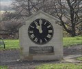 view gallery view galleryE1.9 km |  Former St. Peter's Church Clock - Stanley, UK Former St. Peter's Church Clock - Stanley, UK
in Town Clocks This clock was originally on the bell tower of St. Peter's Church until it was sadly demolished. posted by: dtrebilc location: Yorkshire, United Kingdom date approved: 01/13/2023 last visited: never |
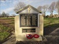 view gallery view galleryE1.9 km |  Former St. Peter's Church War Memorial - Stanley, UK Former St. Peter's Church War Memorial - Stanley, UK
in World War I Memorials and Monuments This war memorial was originally on the outside wall of St. Peter's Church. fter the church was demolished the memorial was restored on a small stone wall in Stanley Cemetery which originally surrounded the church. posted by: dtrebilc location: Yorkshire, United Kingdom date approved: 01/11/2023 last visited: never |
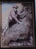 view gallery view galleryE1.9 km | Thatched House, 434 Aberford Road - Stanley, UK in Pictorial Pub Signs This pub sign shows a man working on a roof doing the traditional skilled craft of constructing a thatched roof. posted by: dtrebilc location: Yorkshire, United Kingdom date approved: 01/11/2023 last visited: never |
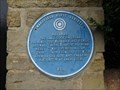 view gallery view galleryE2.1 km |  Lake Lock Railroad - Stanley, UK Lake Lock Railroad - Stanley, UK
in Blue Plaques This blue plaque records a place on the route of the Lake Lock Railroad. posted by: dtrebilc location: Yorkshire, United Kingdom date approved: 01/09/2023 last visited: never |
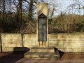
 view gallery view gallerySE2.1 km |  War Memorial Doves Of Peace - Stanley, UK War Memorial Doves Of Peace - Stanley, UK
in Doves of peace This bench stands nearby to a World War I memorial erected afted the war. posted by: dtrebilc location: Yorkshire, United Kingdom date approved: 02/07/2023 last visited: never |
 view gallery view gallerySE2.1 km | No. 1 Polling Hero Fund Memorial - Stanley, UK in World War I Memorials and Monuments This small war memorial is at the side of Aberford Road near to the entrance of Normanton Golf Club. posted by: dtrebilc location: Yorkshire, United Kingdom date approved: 01/11/2023 last visited: never |
 view gallery view gallerySE2.7 km |  Stanley Ferry Marina - Stanley Ferry, UK Stanley Ferry Marina - Stanley Ferry, UK
in UK Historical Markers This information board is just to the north west of the Aire and Calder Navigation which is shared at this point by the long distance cycling and walking trail, the Trans Pennine Trail. posted by: dtrebilc location: Yorkshire, United Kingdom date approved: 01/13/2023 last visited: never |
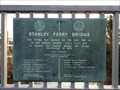 view gallery view gallerySE2.7 km |  Stanley Ferry Bridge - Stanley Ferry, UK Stanley Ferry Bridge - Stanley Ferry, UK
in Grand Opening This replacement road bridge over the river Calder was opened by the then Prime Minister, Harold Wilson O.B.E. F.R.S. M.P. posted by: dtrebilc location: Yorkshire, United Kingdom date approved: 02/06/2023 last visited: never |
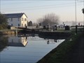 view gallery view galleryE2.9 km |  Birkwood Lock On Aire and Calder Navigation - Bottomboat, UK Birkwood Lock On Aire and Calder Navigation - Bottomboat, UK
in Waterway Locks, Planes and Lifts This lock is on a canalised stretch of Aire and Calder Navigation. posted by: dtrebilc location: Yorkshire, United Kingdom date approved: 03/02/2019 last visited: never |
 view gallery view gallerySE3.1 km | The Lower Calder Valley - Stanley Ferry, UK in UK Historical Markers This information board is on the bank of the Aire and Calder Navigation which is shared at this point by the long distance cycling and walking trail, the Trans Pennine Trail. posted by: dtrebilc location: Yorkshire, United Kingdom date approved: 01/13/2023 last visited: never |
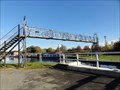 view gallery view gallerySE3.1 km |  Former Ramsdens Footbridge Over Aire And Calder Navigation - Stanley Ferry, UK Former Ramsdens Footbridge Over Aire And Calder Navigation - Stanley Ferry, UK
in Orphaned Bridges This former footbridge stands next to a swing bridge and provided access across the Aire and Calder Navigation to pedestrians when the swing bridge was in the open position. posted by: dtrebilc location: Yorkshire, United Kingdom date approved: 02/20/2019 last visited: never |
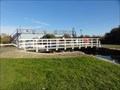 view gallery view gallerySE3.1 km |  Ramsdens Swing Bridge Over Aire And Calder Navigation - Stanley Ferry, UK Ramsdens Swing Bridge Over Aire And Calder Navigation - Stanley Ferry, UK
in Moving Bridges This manual swing bridge provides access across the Aire and Calder Navigation to pedestrians, cyclists and wheel chair users. posted by: dtrebilc location: Yorkshire, United Kingdom date approved: 02/21/2019 last visited: never |
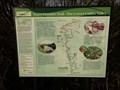
 view gallery view gallerySE3.1 km | Southern Washlands Nature Corridor - Stanley Ferry, UK in Flora and Fauna Information Signs This information board is on the towpath of The Calder and Hebble Navgation and has information about a nature corridor that runs alongsidde the canal. posted by: dtrebilc location: Yorkshire, United Kingdom date approved: 02/08/2023 last visited: never |
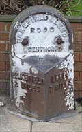
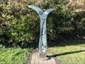 view gallery view gallerySE3.1 km | SUSTRANS Millennium Milestone – Stanley Ferry, UK in Milestones One of 1000 cycle path mileposts sponsored by Royal Bank of Scotland to celebrate both the millennium and the SUSTRANS national cycle network. posted by: dtrebilc location: Yorkshire, United Kingdom date approved: 02/20/2019 last visited: never |
|