 view gallery view gallery S1 km S1 km
|   DO - Rue d'Houdain - Barlin, France DO - Rue d'Houdain - Barlin, France
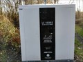
in Places for Recycling [EN] Recycling point for glass. [FR] Point de recyclage pour le verre. posted by:  pmaupin pmaupin location: Hauts-de-France, France date approved: 01/20/2020 last visited: 01/18/2020 |
 view gallery view gallery SW3.1 km SW3.1 km
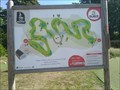
|  Mini-golf - Parc d'ohlain - Maisnil Les Ruitz, France Mini-golf - Parc d'ohlain - Maisnil Les Ruitz, France
in Miniature Golf EN - Ohlain park miniature golf course.
FR - Golf miniature parc d'Ohlain. posted by: geotrouvtou59 location: Hauts-de-France, France date approved: 07/28/2022 last visited: 08/14/2022 |
 view gallery view gallerySW3.2 km |  Disc golf course parc d'olhain - Houdain, France Disc golf course parc d'olhain - Houdain, France
in Disc Golf Courses 18 hole disc golf course at park d olhain. posted by: PetjeOp location: Hauts-de-France, France date approved: 08/12/2022 last visited: 08/19/2022 |
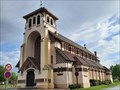
 view gallery view gallery N3.4 km N3.4 km
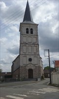
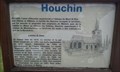
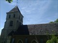
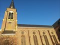
|  Eglise Saint-Omer - Houchin, France Eglise Saint-Omer - Houchin, France
in Roman Catholic Churches [EN] The church Saint-Omer dates from the eighteenth century, it is the parish church of a small town of 700 inhabitants.
[FR] L’église Saint-Omer date du XVIIIe siècle, elle est l'église paroissiale d'une petite petite ville de 700 habitants. posted by: pmaupin location: Hauts-de-France, France date approved: 12/03/2019 last visited: 07/06/2016 |
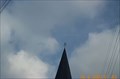
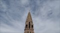
 view gallery view galleryN3.4 km |  Le Clocher de l'Eglise Saint-Omer - Houchin, France Le Clocher de l'Eglise Saint-Omer - Houchin, France
in Bell Towers [EN] The bell tower of the 18th century is the work of the Count of Montmorency, it represents a square tower of sandstone and stone.
[FR] Le clocher du 18ème siècle est l'œuvre du Comte de Montmorency, il représente une tour carrée en grès et en pierre. posted by: pmaupin location: Hauts-de-France, France date approved: 12/03/2019 last visited: 07/06/2016 |
 view gallery view galleryN3.4 km | Eglise Saint-Omer - Houchin, France in This Old Church [EN] The church Saint-Omer dates from the eighteenth century, it is the parish church of a small town of 700 inhabitants. [FR] L’église Saint-Omer date du XVIIIe siècle, elle est l'église paroissiale d'une petite petite ville de 700 habitants. posted by: pmaupin location: Hauts-de-France, France date approved: 12/03/2019 last visited: 07/06/2016 |
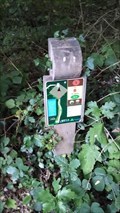
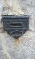
 view gallery view galleryN3.4 km |  Benchmarck - Géodésique Eglise Saint-Omer d'Houchin Benchmarck - Géodésique Eglise Saint-Omer d'Houchin
in French Benchmarks Benchmarck du Pas de Calais posted by: pmaupin location: Hauts-de-France, France date approved: 07/07/2016 last visited: 07/06/2016 |
 view gallery view galleryN3.4 km | ") Eglise Saint-Omer - Houchin, France Eglise Saint-Omer - Houchin, France
in Histoires de France (French historical markers) [FR] L’église Saint-Omer date du XVIIIe siècle, elle est l'église paroissiale d'une petite petite ville de 700 habitants.
[EN] The church Saint-Omer dates from the eighteenth century, it is the parish church of a small town of 700 inhabitants. posted by: pmaupin location: Hauts-de-France, France date approved: 12/03/2019 last visited: 07/06/2016 |
 view gallery view galleryN3.4 km | Benchmark - Église Saint-Omer d'Houchin in French Benchmarks Repère Console du Nivellement Général posted by: pmaupin location: Hauts-de-France, France date approved: 07/07/2016 last visited: 07/06/2016 |
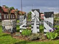
 view gallery view gallery W3.4 km W3.4 km
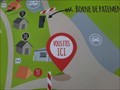
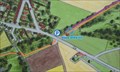
|  Vous Êtes Ici : Camping du parc d'Olhain - Maisnil-Les-Ruitz, France Vous Êtes Ici : Camping du parc d'Olhain - Maisnil-Les-Ruitz, France
in 'You Are Here' Maps [EN] The indications "you are here" can be found on a panel located at the entrance to the Parc d'Olhain campsite.
[FR] Les indications "vous êtes ici" se trouve sur un panneau situé à l'entrée du camping du Parc d'Olhain. posted by: pmaupin location: Hauts-de-France, France date approved: 07/31/2022 last visited: 07/31/2022 |
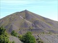 view gallery view galleryW3.5 km |  Terrils du pays à part - Bruay-la-Buissiére, France Terrils du pays à part - Bruay-la-Buissiére, France
in Outdoor Stairways 389 steps lead to the top. At the top you have a fantastic view over the surroundings posted by: PetjeOp location: Hauts-de-France, France date approved: 08/06/2022 last visited: 08/10/2022 |
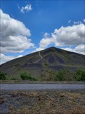 view gallery view galleryW3.7 km |  Terrils n° 2 et 3, 6 - Bassin minier du Nord-Pas de Calais - Ruitz, France, ID=1360-099 Terrils n° 2 et 3, 6 - Bassin minier du Nord-Pas de Calais - Ruitz, France, ID=1360-099
in World Heritage Sites [EN] A stone's throw from the Parc d'Olhain, this protected natural area of ??nearly 100 hectares is dominated by two twin slag heaps over 180 m high offering a breathtaking view of the Artois.
[FR] A quelques encablures du parc d’Olhain, cet espace naturel protégé de près de 100 hectares est dominé par deux terrils jumeaux de plus 180 m de hauteur offrant une vue imprenable sur l’Artois. posted by: pmaupin location: Hauts-de-France, France date approved: 07/18/2022 last visited: 08/15/2022 |
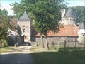
 view gallery view gallerySW3.9 km |  Château d’Olhain - Fresnicourt-le-Dolmen, France Château d’Olhain - Fresnicourt-le-Dolmen, France
in Castles FR - Le château d’Olhain s’élève sur la commune de Fresnicourt le Dolmen.
EN - The castle of Olhain rises in the town of Fresnicourt le Dolmen. posted by: geotrouvtou59 location: Hauts-de-France, France date approved: 07/13/2022 last visited: 07/31/2022 |
 view gallery view gallerySW3.9 km |  Château d'Olhain - Fresnicourt-le-Dolmen, France Château d'Olhain - Fresnicourt-le-Dolmen, France
in Wikipedia Entries FR - Le château d’Olhain s’élève sur la commune de Fresnicourt le Dolmen.
EN - The castle of Olhain rises in the town of Fresnicourt le Dolmen. posted by: geotrouvtou59 location: Hauts-de-France, France date approved: 07/13/2022 last visited: 07/31/2022 |
 view gallery view gallery NW3.9 km NW3.9 km
| Vous Etes Ici: Les Terrils des Falandes - Haillicourt, France in 'You Are Here' Maps [EN] The indications "you are here" can be found on an information sign at the beginning of the footpaths of Les Terrils des Falandes.
[FR] Les indications "vous êtes ici" se trouve sur un panneau d'information des sentiers des Terrils des Falandes. posted by: pmaupin location: Hauts-de-France, France date approved: 06/02/2017 last visited: 04/23/2017 |
 view gallery view galleryS4 km | Eglise Notre-Dame-de-la-Nativité - Fresnicourt le Dolmen , France in This Old Church FR - L’église Notre-Dame-de-la-Nativité, qui contiendrait les reliques de Sainte-Constance.
EN - The Notre-Dame-de-la-Nativité church, which would contain the relics of Sainte-Constance. posted by: geotrouvtou59 location: Hauts-de-France, France date approved: 07/17/2022 last visited: 07/19/2022 |
 view gallery view gallerySW4 km |  Château d'Olhain - Fresnicourt-le-Dolmen, France Château d'Olhain - Fresnicourt-le-Dolmen, France
in Monuments Historiques Français FR - Le château d’Olhain s’élève sur la commune de Fresnicourt le Dolmen.
EN - The castle of Olhain rises in the town of Fresnicourt le Dolmen. posted by: geotrouvtou59 location: Hauts-de-France, France date approved: 07/13/2022 last visited: 08/13/2022 |
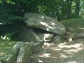
 view gallery view galleryS4 km |  Dolmen La Table des Fées - Fresnicourt-le-Dolmen, France Dolmen La Table des Fées - Fresnicourt-le-Dolmen, France
in Megalithic Monuments FR - La Table des Fées est une allée couverte situé sur le territoire de la commune de Fresnicourt-le-Dolmen.
EN - La Table des Fées is a covered alley located on the territory of the municipality of Fresnicourt-le-Dolmen. posted by: geotrouvtou59 location: Hauts-de-France, France date approved: 07/14/2022 last visited: 07/31/2022 |
 view gallery view galleryS4 km | Table des Fées - Fresnicourt-le-Dolmen, France in Wikipedia Entries FR - La Table des Fées est une allée couverte situé sur le territoire de la commune de Fresnicourt-le-Dolmen.
EN - La Table des Fées is a covered alley located on the territory of the municipality of Fresnicourt-le-Dolmen. posted by: geotrouvtou59 location: Hauts-de-France, France date approved: 07/13/2022 last visited: 07/31/2022 |
 view gallery view galleryS4 km | Dolmen La Table des Fées - Fresnicourt-le-Dolmen, France in Monuments Historiques Français FR - La Table des Fées est une allée couverte situé sur le territoire de la commune de Fresnicourt-le-Dolmen.
EN - La Table des Fées is a covered alley located on the territory of the municipality of Fresnicourt-le-Dolmen. posted by: geotrouvtou59 location: Hauts-de-France, France date approved: 07/13/2022 last visited: 07/31/2022 |
 view gallery view gallery NE4.2 km NE4.2 km
| L'église Saint Martin de Noeux-les-Mines, France in Roman Catholic Churches [EN] The church is in the center of Noeux-les-Mines.
[FR] L'église se situe au centre de la ville de Noeux-les-Mines. posted by: Team Glandouillage location: Hauts-de-France, France date approved: 01/18/2016 last visited: 01/17/2016 |
 view gallery view galleryN4.7 km | Benchmark Géodésique Eglise DROUVIN-LE-MARAIS A in French Benchmarks Benchmark du Nord posted by: geotrouvtou59 location: Hauts-de-France, France date approved: 05/10/2015 last visited: 05/10/2015 |
 view gallery view gallery E4.8 km E4.8 km
|  Église Sainte-Marguerite - Sains-en-Gohelle (Pas-de-Calais), France Église Sainte-Marguerite - Sains-en-Gohelle (Pas-de-Calais), France
in Art Deco - Art Nouveau [FR] L'église actuelle est construite par le fameux architecte Louis Cordonnier à partir de 1924 et inaugurée le 2 mai 1926. [EN] The present church was constructed by the famous architect Louis Cordonnier beginning in 1924 and inaugurated in 1926. posted by: RakeInTheCache location: Hauts-de-France, France date approved: 05/30/2021 last visited: never |
 view gallery view galleryE4.8 km | Cité n°10 - Bassin minier du Nord-Pas de Calais - Sains-en-Gohelle, France, ID=1360-086 in World Heritage Sites [FR] Construite dans les années 1920, la cité 10 compte environ 650 logements répartis selon un strict plan orthogonal. [EN] Consructed in the 1920's, the garden city 10 is made up of about 650 lodgings arranged along a strict orthogonal plan. posted by: RakeInTheCache location: Hauts-de-France, France date approved: 05/30/2021 last visited: never |
 view gallery view galleryNE4.8 km |  McDonald's - Noeux-les-mines, Nord-Pas-de-Calais, France McDonald's - Noeux-les-mines, Nord-Pas-de-Calais, France
in Wi-Fi Hotspots A McDonald's off of park loisinord. posted by: Team Glandouillage location: Hauts-de-France, France date approved: 01/20/2016 last visited: 01/18/2016 |
|