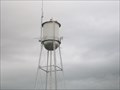
 view gallery view gallery NE1 km NE1 km
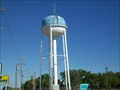
|   Watertower, Ridgeview, South Dakota Watertower, Ridgeview, South Dakota
in Water Towers A modern tower northeast of town, on US Highway 212. posted by:  NGComets NGComets location: South Dakota date approved: 09/12/2012 last visited: 06/16/2013 |
 view gallery view gallery SW9.2 km SW9.2 km
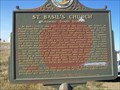
|  St. Basil Church, Mossman, South Dakota St. Basil Church, Mossman, South Dakota
in South Dakota Historical Markers Built on the Cheyenne Indian Reservation in 1917. Sign erected in 1974. posted by: NGComets location: South Dakota date approved: 09/12/2012 last visited: 06/16/2013 |
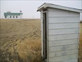 view gallery view gallerySW9.2 km |  Outhouse, St. Basil Church, Mossman, South Dakota Outhouse, St. Basil Church, Mossman, South Dakota
in Outhouses Providing service for St. Basil's Church, Mossman, SD. posted by: NGComets location: South Dakota date approved: 11/01/2012 last visited: never |
 view gallery view gallery W24.5 km W24.5 km
| Watertower, Parade, South Dakota in Water Towers A modern watertower, it stands out in contrast to the stark prairie. posted by: NGComets location: South Dakota date approved: 09/16/2012 last visited: never |
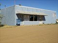
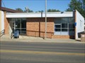 view gallery view galleryW35.6 km |  Eagle Butte, South Dakota 57625 Eagle Butte, South Dakota 57625
in U.S. Post Offices Small town post office. posted by: NGComets location: South Dakota date approved: 09/17/2012 last visited: never |
 view gallery view galleryW35.6 km | Watertower, Eagle Butte, South Dakota in Water Towers One of 5 watertowers in this small town. posted by: NGComets location: South Dakota date approved: 09/12/2012 last visited: never |
 view gallery view galleryW35.6 km | Tasunka Masa ~ Iron Horse in South Dakota Historical Markers Chicago Milwaukee & St. Paul Railroad Depot in Eagle Butte, SD on the Cheyenne River Sioux Indian Reservation. posted by: plainsdrifter358 location: South Dakota date approved: 07/23/2007 last visited: 07/17/2007 |
 view gallery view galleryW36.9 km |  Eagle Butte Cemetery, Eagle Butte, South Dakota Eagle Butte Cemetery, Eagle Butte, South Dakota
in Worldwide Cemeteries A large cemetery northwest of town with about 1,200 graves in it. posted by: NGComets location: South Dakota date approved: 09/14/2012 last visited: 06/16/2013 |
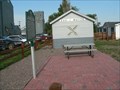
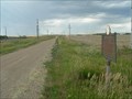
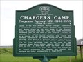 view gallery view gallery E40.1 km E40.1 km
| Chargers Camps ~Cheyenne Agency 1891 - 1959 in South Dakota Historical Markers The new location chosen for our Agency "town" was the site of Chief Martin Charger's permanent campsite located at a point midway between the Cheyenne and Moreau rivers on the west bank of the Missouri river. posted by: MNSearchers location: South Dakota date approved: 05/29/2007 last visited: 06/16/2013 |
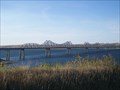 view gallery view galleryE40.4 km |  Truss Bridge, Missouri River, Forest City, South Dakota Truss Bridge, Missouri River, Forest City, South Dakota
in Truss Bridges One of the few bridges spanning the Missouri River in South Dakota. posted by: NGComets location: South Dakota date approved: 09/13/2012 last visited: 09/08/2019 |
 view gallery view gallery NW43.9 km NW43.9 km
| Timber Lake, South Dakota 57656 in U.S. Post Offices Small town post office. posted by: NGComets location: South Dakota date approved: 06/22/2010 last visited: 06/16/2013 |
 view gallery view galleryNW44.1 km | Watertower, Timber Lake, South Dakota in Water Towers Small town watertower. posted by: NGComets location: South Dakota date approved: 06/22/2010 last visited: 06/16/2013 |
 view gallery view galleryE46 km | Original Site Medicine Rock <== 2.6 miles ==< in South Dakota Historical Markers Medicine Rock was a landmark in its day, a sacred rock, a flat 12x20 limestone on a hillside just south of the Little Cheyenne River, with man's and other footprints on it. It is now submerged under 50 feet of water, 125 feet from shore. posted by: plainsdrifter358 location: South Dakota date approved: 06/27/2006 last visited: 10/29/2011 |
 view gallery view galleryW49.7 km | Lantry, South Dakota 57636 in U.S. Post Offices Small town post office. posted by: NGComets location: South Dakota date approved: 09/17/2012 last visited: never |
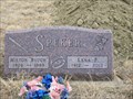 view gallery view galleryW50.2 km |  100 - Lena F. Speker 100 - Lena F. Speker
in Headstones of Centenarians Many events were seen by the lady. posted by: NGComets location: South Dakota date approved: 11/05/2012 last visited: never |
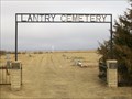 view gallery view galleryW50.2 km | Lantry Cemetery, Lantry, South Dakota in Worldwide Cemeteries Small community cemetery just south of Lantry with about 90 graves. posted by: NGComets location: South Dakota date approved: 03/25/2013 last visited: never |
 view gallery view galleryW50.5 km | Watertower, Lantry, South Dakota in Water Towers A modern watertower north of Lantry, SD. posted by: NGComets location: South Dakota date approved: 09/12/2012 last visited: never |
 view gallery view galleryNW53.6 km | Firesteel in South Dakota Historical Markers The town of Firesteel takes its name from nearby Firesteel Creek posted by: MNSearchers location: South Dakota date approved: 06/15/2007 last visited: 07/15/2007 |
 view gallery view galleryNE53.8 km | Sakakawea Historical Marker Plaque & Obelisk -- Standing Rock Sioux Reservation, nr Mobridge SD in South Dakota Historical Markers The young Shoshone woman from the Big Horn Mountains in Montana that served as guide and interpreter for the Lewis & Clerk Expedition is honored by the Standing Rock Sioux (2001) and the State of South Dakota (1960s) at this meaningful place. posted by: plainsdrifter358 location: South Dakota date approved: 07/05/2006 last visited: 02/13/2023 |
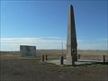
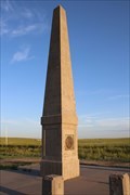
 view gallery view galleryNE53.8 km |  Sakakawea Monument and Marker -- Standing Rock Sioux Reservation, nr Mobridge SD Sakakawea Monument and Marker -- Standing Rock Sioux Reservation, nr Mobridge SD
in Lewis and Clark Trail Tall obelisk with a medallion of Sakakawea and her son Jean Baptiste Charbonneau stands near a South Dakota state historical marker memorializing her contribution to the Lewis & Clark Expedition, along the Missouri River (Lake Oahe) posted by: Benchmark Blasterz location: South Dakota date approved: 02/24/2023 last visited: 03/01/2023 |
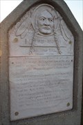
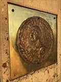 view gallery view galleryNE53.8 km |  Sakakawea Monument Relief -- Standing Rock Sioux Reservation, nr Mobridge SD Sakakawea Monument Relief -- Standing Rock Sioux Reservation, nr Mobridge SD
in Relief Art Sculptures A tall obelisk with a medallion of Sakakawea and her son Jean Baptiste Charbonneau stands near a South Dakota state historical marker memorializing her contribution to the Lewis & Clark Expedition posted by: Benchmark Blasterz location: South Dakota date approved: 02/14/2023 last visited: 02/15/2023 |
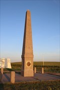
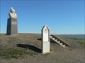
 view gallery view galleryNE53.8 km |  Sakakawea Monument-- Standing Rock Sioux Reservation, nr Mobridge SD Sakakawea Monument-- Standing Rock Sioux Reservation, nr Mobridge SD
in Obelisks A tall obelisk with a medallion of Sakakawea and her son Jean Baptiste Charbonneau stands near a South Dakota state historical marker memorializing her contribution to the Lewis & Clark Expedition posted by: Benchmark Blasterz location: South Dakota date approved: 02/14/2023 last visited: 02/15/2023 |
 view gallery view galleryNE54.1 km | Tatanka Iyotale (Chief Sitting Bull) -- Grave of Tatanka Iyotale, Standing Rock Sioux Reservation, nr Mobridge SD in Relief Art Sculptures A relief monument in the form of a tombstone near the grave of Tatanka Iyotale (Chief Sitting Bull), on the Standing Rock Sioux reservation near Mobridge, South Dakota posted by: Benchmark Blasterz location: South Dakota date approved: 02/14/2023 last visited: 02/15/2023 |
 view gallery view galleryNE54.1 km |  Tatanka Iyotale (Sitting Bull) -- Grave of Tatanka Iyotale, Standing Rock Sioux Reservation, nr Mobridge SD Tatanka Iyotale (Sitting Bull) -- Grave of Tatanka Iyotale, Standing Rock Sioux Reservation, nr Mobridge SD
in Smithsonian Art Inventory Sculptures A relief monument in the form of a tombstone near the grave of Tatanka Iyotale (Chief Sitting Bull), on the Standing Rock Sioux reservation near Mobridge, South Dakota, listed in the Smithsonia Database posted by: Benchmark Blasterz location: South Dakota date approved: 03/08/2023 last visited: 03/09/2023 |
 view gallery view galleryNE54.1 km | Tatanka Iyotake aka Sitting Bill ~ 1831 - 1890 in South Dakota Historical Markers Grave Site atop the Missouri River buttes of the Famous Native American Chief Sitting Bull (Tatanka Iyotake). posted by: plainsdrifter358 location: South Dakota date approved: 06/29/2006 last visited: 02/13/2023 |
|