 view gallery view gallery SW11.6 km SW11.6 km
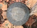
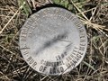
|   T40N R68W S28 S27 S34 S33 - Converse County, Wyoming T40N R68W S28 S27 S34 S33 - Converse County, Wyoming
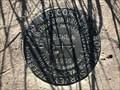
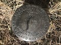
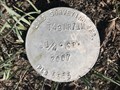
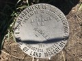
in Public Land Survey Marks A section corner marker in the vicinity of Dull Center in northern Converse County. posted by:  Tom.dog Tom.dog location: Wyoming date approved: 04/08/2024 last visited: never |
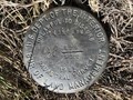
 view gallery view gallery W26.1 km W26.1 km
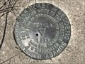
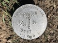
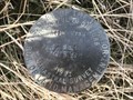
| T40N R70W S9 S10 S15 S16 - Converse County, Wyoming in Public Land Survey Marks A USDI-Bureau of Land Management section corner marker on Thunder Basin National Grassland. posted by: Tom.dog location: Wyoming date approved: 12/23/2022 last visited: never |
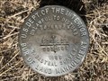
 view gallery view gallery NW26.2 km NW26.2 km
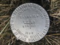
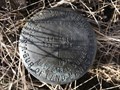
| T43N R69W S29 S32 1/4 - Campbell County, Wyoming in Public Land Survey Marks A USDI-Bureau of Land Management quarter corner marker to the southwest of the School Creek and Little Thunder Creek confluence. posted by: Tom.dog location: Wyoming date approved: 10/12/2023 last visited: never |
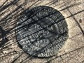
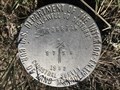
 view gallery view galleryNW26.7 km | T43N R69W S30 S29 S32 S31 - Campbell County, Wyoming in Public Land Survey Marks This USDI-Bureau of Land Management section corner marker can be found a short distance to the east of School Creek Road. posted by: Tom.dog location: Wyoming date approved: 10/12/2023 last visited: never |
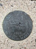
 view gallery view galleryW31.9 km |  TECKLA NO 2 - Campbell County, Wyoming TECKLA NO 2 - Campbell County, Wyoming
in U.S. Benchmarks Reference mark 2 for triangulation station TECKLA (OU0391). posted by: Tom.dog location: Wyoming date approved: 06/11/2023 last visited: never |
 view gallery view galleryW31.9 km | TECKLA NO 1 - Campbell County, Wyoming in U.S. Benchmarks Reference mark 1 for triangulation station TECKLA (OU0391). posted by: Tom.dog location: Wyoming date approved: 06/11/2023 last visited: never |
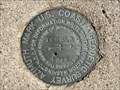
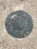
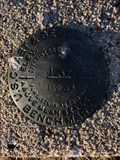
 view gallery view galleryW31.9 km | TECKLA (OU0391) - Campbell County, Wyoming in U.S. Benchmarks This U.S. Coast & Geodetic Survey triangulation station is at the top of a small rise to the northeast of Antelope Road. posted by: Tom.dog location: Wyoming date approved: 06/11/2023 last visited: never |
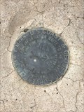
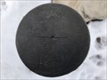
 view gallery view galleryW32.7 km | TECKLA Azimuth Mark - Campbell County, Wyoming in U.S. Benchmarks This is the azimuth mark for triangulation station TECKLA (OU0391). posted by: Tom.dog location: Wyoming date approved: 06/11/2023 last visited: never |
 view gallery view galleryW32.7 km |  TECKLA Azimuth Mark - Campbell County, Wyoming TECKLA Azimuth Mark - Campbell County, Wyoming
in Azimuth Benchmarks This is the azimuth mark for triangulation station TECKLA (OU0391). posted by: Tom.dog location: Wyoming date approved: 07/02/2023 last visited: never |
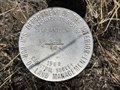 view gallery view galleryW33.6 km | T42N R71W S13 S24 1/4 - Campbell County, Wyoming in Public Land Survey Marks A quarter corner marker to the east of Antelope Road. posted by: Tom.dog location: Wyoming date approved: 04/15/2024 last visited: never |
 view gallery view galleryW34.4 km | T42N R71W S14 S13 S24 S23 RM - Campbell County, Wyoming in Public Land Survey Marks A USDI-Bureau of Land Management section corner reference marker on the west side of the now-abandoned Piney Canyon Road. posted by: Tom.dog location: Wyoming date approved: 04/15/2024 last visited: never |
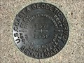
 view gallery view gallerySW38 km | BILL (OU0415) - Converse County, Wyoming in U.S. Benchmarks This USGS benchmark is located at the top of a rise adjacent to State Highway 59, about 2.9 miles to the northwest of the beautiful "blink-and-you'll-miss-it" town of Bill, Wyoming. posted by: Tom.dog location: Wyoming date approved: 01/08/2023 last visited: never |
 view gallery view gallerySW38 km | BILL NO 2 - Converse County, Wyoming in U.S. Benchmarks Reference mark 2 for USGS benchmark BILL (OU0415). posted by: Tom.dog location: Wyoming date approved: 01/08/2023 last visited: never |
 view gallery view gallerySW38 km | BILL NO 1 - Converse County, Wyoming in U.S. Benchmarks Reference mark 1 for USGS benchmark BILL (OU0415). posted by: Tom.dog location: Wyoming date approved: 01/08/2023 last visited: never |
 view gallery view gallerySW39.4 km | J 57 (OU0221) - Converse County, Wyoming in U.S. Benchmarks A benchmark on the north side of USFS Road 961 a short distance west of WY State Highway 59. posted by: Tom.dog location: Wyoming date approved: 10/21/2022 last visited: never |
 view gallery view galleryNW43.8 km | T43N R71W S8 S9 S16 S17 - Campbell County, Wyoming in Public Land Survey Marks A privately monumented section corner located not-too-terribly far from the Black Thunder coal mine. posted by: Tom.dog location: Wyoming date approved: 04/08/2024 last visited: never |
 view gallery view galleryW44.3 km | Z 57 (OU0204) - Campbell County, Wyoming in U.S. Benchmarks This benchmark is located a short distance to the west of State Highway 59 in southern Campbell County on Thunder Basin National Grassland. posted by: Tom.dog location: Wyoming date approved: 03/19/2023 last visited: never |
 view gallery view galleryW44.6 km | T42N R72W S27 S26 1/4 - Campbell County, Wyoming in Public Land Survey Marks This quarter corner marker is on Thunder Basin National Grassland, to the west of State Highway 59. posted by: Tom.dog location: Wyoming date approved: 02/03/2024 last visited: never |
 view gallery view galleryNW44.9 km | T43N R71W C 1/4 - Campbell County, Wyoming in Public Land Survey Marks A center quarter corner marker on Thunder Basin National Grassland. posted by: Tom.dog location: Wyoming date approved: 10/12/2023 last visited: never |
 view gallery view galleryNW45.2 km | T43N R71W S8 N 1/16 - Campbell County, Wyoming in Public Land Survey Marks A privately monumented sixteenth corner marker on Thunder Basin National Grassland. posted by: Tom.dog location: Wyoming date approved: 10/12/2023 last visited: never |
 view gallery view galleryNW45.2 km | T43N R71W S7 S8 S17 S18 - Campbell County, Wyoming in Public Land Survey Marks A USDI-Bureau of Land Management section corner marker in the Little Thunder Creek drainage. posted by: Tom.dog location: Wyoming date approved: 04/08/2024 last visited: never |
 view gallery view galleryNW45.5 km | T43N R71W S7 S8 1/4 - Campbell County, Wyoming in Public Land Survey Marks A quarter corner marker located in the grasslands to the south of State Highway 450. posted by: Tom.dog location: Wyoming date approved: 04/08/2024 last visited: never |
 view gallery view galleryNW46 km | T43N R71W S6 S5 S8 S7 RM - Campbell County, Wyoming in Public Land Survey Marks A USDI-Bureau of Land Management section corner reference marker on the south side of State Highway 450. posted by: Tom.dog location: Wyoming date approved: 04/08/2024 last visited: never |
 view gallery view galleryNW46.5 km | T43N R72W S13 S24 1/4 - Campbell County, Wyoming in Public Land Survey Marks A USDI-Bureau of Land Management quarter corner marker on the north side of Nicholson Draw. posted by: Tom.dog location: Wyoming date approved: 04/15/2024 last visited: never |
 view gallery view galleryNW47.2 km | T43N R72W S14 S13 S24 S23 - Campbell County, Wyoming in Public Land Survey Marks A section corner marker on Thunder Basin National Grassland to the south of the town of Wright. posted by: Tom.dog location: Wyoming date approved: 04/15/2024 last visited: never |
|