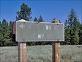
 view gallery view gallery NW2.9 km NW2.9 km
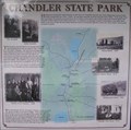
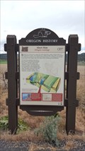
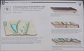
|   Chandler State Park Chandler State Park
in Oregon Historical Markers History sign at Chandler State Park.
posted by:  Volcanoguy Volcanoguy location: Oregon date approved: 10/17/2007 last visited: 03/03/2013 |
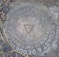
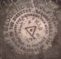
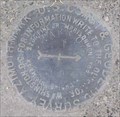
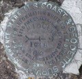
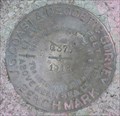 view gallery view galleryNW2.9 km |  NY0105 - USCGS Q375, OR NY0105 - USCGS Q375, OR
in U.S. Benchmarks USCGS Benchmark Q375 posted by: Volcanoguy location: Oregon date approved: 10/19/2007 last visited: 03/03/2013 |
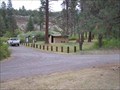 view gallery view galleryNW3.2 km |  Chandler State Wayside - Oregon Chandler State Wayside - Oregon
in State/Provincial Parks This wayside park is located along U.S. Hwy. 395 about 15 miles north of Lakeview, Oregon. posted by: Volcanoguy location: Oregon date approved: 10/26/2007 last visited: 03/03/2013 |
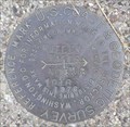
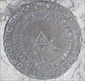
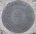 view gallery view gallery W3.7 km W3.7 km
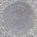
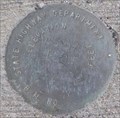
| NY0102 - USCGS P375, OR in U.S. Benchmarks USCGS Benchmark P375. posted by: Volcanoguy location: Oregon date approved: 10/20/2007 last visited: 10/20/2007 |
 view gallery view galleryW3.7 km | NY0795 - USCGS DICK, OR in U.S. Benchmarks USCGS Triangulation Station DICK. posted by: Volcanoguy location: Oregon date approved: 10/19/2007 last visited: 10/20/2007 |
 view gallery view galleryW3.7 km | NY0795 - USCGS DICK NO 2, OR in U.S. Benchmarks USCGS Reference Mark DICK NO 2 posted by: Volcanoguy location: Oregon date approved: 10/19/2007 last visited: 10/20/2007 |
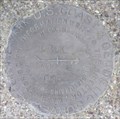 view gallery view galleryW3.7 km | NY0795 - USCGS DICK NO 1, OR in U.S. Benchmarks USCGS Reference Mark DICK NO 1. posted by: Volcanoguy location: Oregon date approved: 10/19/2007 last visited: 10/20/2007 |
 view gallery view gallery N7.9 km N7.9 km
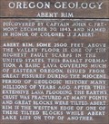
| Abert Rim (Hwy 31) in Oregon Historical Markers Oregon Geology Marker about Abert Rim on Ore. Hwy. 31. *UPDATE 6/4/17* This Beaver Board has been replaced and relocated to the west side of the highway and further south from the original. New coordinates updated. posted by: Volcanoguy location: Oregon date approved: 10/16/2007 last visited: 06/04/2017 |
 view gallery view galleryN7.9 km |  Abert Rim - Oregon Geology - Lake County, OR Abert Rim - Oregon Geology - Lake County, OR
in Places of Geologic Significance A historical 'Beaver Board' located just of US 395 highlights the geological history of nearby Abert Rim. posted by: NW_history_buff location: Oregon date approved: 06/15/2017 last visited: never |
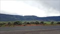
 view gallery view gallery SE8 km SE8 km
|  North Warner Viewpoint, Lake County, Oregon North Warner Viewpoint, Lake County, Oregon
in Scenic Overlooks A rustic viewpoint in the Fremont National Forest overlooking Warner Valley in Lake County, Oregon. posted by:  Flyin'SpiderFam Flyin'SpiderFam location: Oregon date approved: 07/26/2008 last visited: never |
 view gallery view galleryN10.1 km | NY0793 - USCGS VALLEY FALLS, OR in U.S. Benchmarks USCGS Triangulation Station VALLEY FALLS. posted by: Volcanoguy location: Oregon date approved: 10/17/2007 last visited: 10/17/2007 |
 view gallery view galleryN10.1 km | NY0793 - USCGS VALLEY FALLS NO 5, OR in U.S. Benchmarks USCGS Reference Mark VALLEY FALLS NO 5. posted by: Volcanoguy location: Oregon date approved: 10/17/2007 last visited: 10/17/2007 |
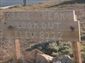 view gallery view gallerySE13.5 km |  Drake Peak Lookout, 8222 feet elevation - Oregon Drake Peak Lookout, 8222 feet elevation - Oregon
in Elevation Signs Drake Peak. The fire lookout here, now retired, can be rented for an overnight fee from the Forest Service through the summer and fall months. posted by: Flyin'SpiderFam location: Oregon date approved: 07/26/2008 last visited: never |
 view gallery view galleryN16.7 km | ODOT V 597, OR in U.S. Benchmarks ODOT benchmark on Chewaucan River bridge. posted by: Volcanoguy location: Oregon date approved: 10/17/2007 last visited: 10/17/2007 |
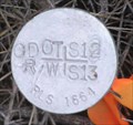 view gallery view galleryN16.7 km | ODOT R/W 12/13, OR in U.S. Benchmarks ODOT Right of Way Mark on Section Line between Sections 12 & 13. posted by: Volcanoguy location: Oregon date approved: 10/17/2007 last visited: 10/17/2007 |
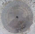 view gallery view galleryN16.9 km | NY0754 - USCGS CHEWAUCAN, OR in U.S. Benchmarks USCGS Triangulation Station CHEWAUCAN. posted by: Volcanoguy location: Oregon date approved: 10/15/2007 last visited: 10/16/2007 |
 view gallery view galleryN17.5 km | A fractured piece of the Earth’s crust in Oregon Historical Markers One of three signs about the Abert Rim and Abert Lake area on U.S. Hwy. 395. posted by: Volcanoguy location: Oregon date approved: 10/16/2007 last visited: 08/16/2019 |
 view gallery view galleryN22.2 km | NY0755 - USCGS NARROWS AZI MK, OR in U.S. Benchmarks USCGS Azimuth Mark NARROWS. posted by: Volcanoguy location: Oregon date approved: 10/17/2007 last visited: 10/17/2007 |
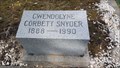 view gallery view gallery S22.4 km S22.4 km
|  101 - Gwendolyne Corbett Snyder - Lakeview, OR 101 - Gwendolyne Corbett Snyder - Lakeview, OR
in Headstones of Centenarians One of a few centenarians located in historic IOOF Cemetery. posted by: NW_history_buff location: Oregon date approved: 10/22/2019 last visited: never |
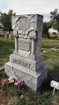 view gallery view galleryS22.4 km |  Clara E. Rehart - IOOF Cemetery - Lakeview, OR Clara E. Rehart - IOOF Cemetery - Lakeview, OR
in Woodmen of the World Grave Markers/Monuments One of a few WoW headstones located in historic IOOF Cemetery. posted by: NW_history_buff location: Oregon date approved: 10/21/2019 last visited: never |
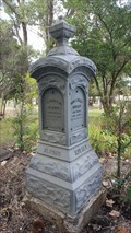 view gallery view galleryS22.4 km |  Thomas B. Alford & Rosa Irene Mulkey - IOOF Cemetery - Lakeview, OR Thomas B. Alford & Rosa Irene Mulkey - IOOF Cemetery - Lakeview, OR
in Zinc Headstones One of a number of zinc headstones located in historic IOOF Cemetery. posted by: NW_history_buff location: Oregon date approved: 10/22/2019 last visited: never |
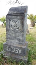 view gallery view galleryS22.5 km | Walter D. Tracy - IOOF Cemetery - Lakeview, OR in Woodmen of the World Grave Markers/Monuments One of a few Wow headstones located in historic IOOF Cemetery. posted by: NW_history_buff location: Oregon date approved: 10/21/2019 last visited: never |
 view gallery view galleryN22.5 km | NY0749 - USCGS MIOCENE NO 2, OR in U.S. Benchmarks USCGS Reference Mark MIOCENE NO 2. posted by: Volcanoguy location: Oregon date approved: 10/17/2007 last visited: 10/17/2007 |
 view gallery view galleryN22.5 km | NY0749 - USCGS MIOCENE, OR in U.S. Benchmarks USCGS Triangulation Station MIOCENE. posted by: Volcanoguy location: Oregon date approved: 10/17/2007 last visited: 06/07/2021 |
 view gallery view galleryN22.5 km | Abert Rim (Hwy 395) in Oregon Historical Markers Oregon Geology Marker about Abert Rim on U.S. Hwy. 395. posted by: Volcanoguy location: Oregon date approved: 10/16/2007 last visited: 12/30/2013 |
|