 view gallery view gallery N2.6 km N2.6 km
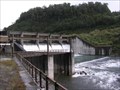
|   Rangipo Dam. Central North Island. New Zealand. Rangipo Dam. Central North Island. New Zealand.
in Water Dams Rangipo Dam is part of the Tongariro Hydro Scheme in the Central North Island of New Zealand. posted by:  Punga and Paua Punga and Paua location: New Zealand date approved: 08/18/2008 last visited: 08/19/2008 |
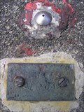 view gallery view galleryN3.4 km |  Survey Marker at the Waihohonu Tunnel. Central Plateau. New Zealand. Survey Marker at the Waihohonu Tunnel. Central Plateau. New Zealand.
in Australia/NZ Benchmarks A metal survey marker for the Tongariro Hydro Scheme is set into the concrete of a hydro structure near the Rangipo Dam on the Volcanic Plateau. posted by: Punga and Paua location: North Island, New Zealand date approved: 02/14/2010 last visited: 02/14/2010 |
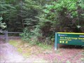
 view gallery view gallery W4.5 km W4.5 km
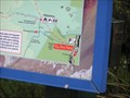
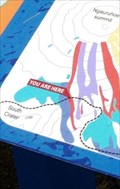
|  Tongariro Northern Circuit, Waihohonu. Desert Rd. North Is. New Zealand. Tongariro Northern Circuit, Waihohonu. Desert Rd. North Is. New Zealand.
in 'You Are Here' Maps You Are Here - at the Waihohonu entrance to the Tongariro Northern Circuit tramping track around the mountains of the Tongariro National Park in the Central North Island of New Zealand. posted by: Punga and Paua location: North Island, New Zealand date approved: 07/27/2015 last visited: 07/27/2015 |
 view gallery view gallery SW6.6 km SW6.6 km
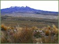
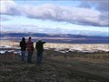
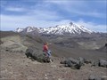
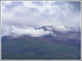
|  Volcano Mountain View over the Desert Rd. North Is. New Zealand. Volcano Mountain View over the Desert Rd. North Is. New Zealand.
in Scenic Overlooks A view from the top of the Old Trig Hill near the Desert Road which runs through the Central North Island. Bring your tramping boots. posted by: Punga and Paua location: North Island, New Zealand date approved: 10/13/2020 last visited: 10/13/2020 |
 view gallery view gallerySW6.6 km | GG (Kaimanawa SD), Desert Road. North Island. New Zealand. in Australia/NZ Benchmarks GG (Kaimanawa SD) stands on top of a small hill beneath the Kaimanawa Ranges, alongside the busy Desert Road through the central North Island of NZ. posted by: Punga and Paua location: North Island, New Zealand date approved: 02/27/2016 last visited: 02/27/2016 |
 view gallery view galleryN6.9 km | Tree Trunk Gorge Track. Central Plateau. New Zealand. in Scenic Hikes This lovely walk through mountain beech forest follows an old survey track along the side of the upper Tongariro River in the Kaimanawa Forest Park. posted by: Punga and Paua location: New Zealand date approved: 07/29/2008 last visited: 04/13/2008 |
 view gallery view galleryN6.9 km |  Tree Trunk Gorge MTB Track. Central Plateau. New Zealand. Tree Trunk Gorge MTB Track. Central Plateau. New Zealand.
in Mountain Bike Trailheads This popular ride starts out on the Desert road and follows an old survey track along the side of the upper Tongariro River in the Kaimanawa Forest Park. posted by: Punga and Paua location: New Zealand date approved: 07/30/2008 last visited: 04/12/2008 |
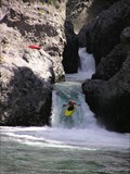
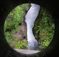 view gallery view galleryN7.1 km |  The Force of Nature. Central North Is. New Zealand. The Force of Nature. Central North Is. New Zealand.
in Best Kept Secrets Not many people venture off the main highway to discover the spectacular secret hidden within this narrow gorge. posted by: Punga and Paua location: North Island, New Zealand date approved: 07/22/2008 last visited: 07/27/2008 |
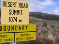 view gallery view gallerySW8.5 km |  Desert Road Summit. Central North Island. New Zealand. Desert Road Summit. Central North Island. New Zealand.
in Elevation Signs The elevation sign at the summit of the Desert Road through the Central North Island. posted by: Punga and Paua location: New Zealand date approved: 08/26/2008 last visited: 01/04/2016 |
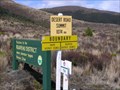 view gallery view gallerySW8.5 km |  Taupo District - Ruapehu District. North Is. New Zealand. Taupo District - Ruapehu District. North Is. New Zealand.
in Border Crossings At the summit of the Desert Road, the boundary border separates the Taupo District and the Ruapehu District. posted by: Punga and Paua location: North Island, New Zealand date approved: 02/20/2011 last visited: 01/04/2016 |
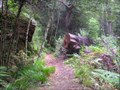
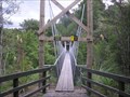 view gallery view galleryN9.8 km |  Pillars of Hercules Bridge. Central Plateau. New Zealand. Pillars of Hercules Bridge. Central Plateau. New Zealand.
in Pedestrian Suspension Bridges A new suspension footbridge across the upper Tongariro River at the Pillars of Hercules in the Kaimanawa Forest Park was built in May 2006. . posted by: Punga and Paua location: New Zealand date approved: 01/21/2009 last visited: 01/22/2009 |
 view gallery view galleryW11.9 km | Rangipo Desert Scenery from Tukino. Central North Island. New Zealand. in Scenic Overlooks A stunning viewpoint across the Rangipo Desert and Desert Road scenery in the Central North Island mountain region. posted by: Punga and Paua location: North Island, New Zealand date approved: 09/29/2019 last visited: 09/29/2019 |
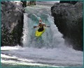 view gallery view galleryN11.9 km |  Kayak Down A Waterfall Kayak Down A Waterfall
in Photo Goals Your goal is to kayak over a natural waterfall, and upload a photo of your attempt. Get wet, have fun, while keeping it safe and within your capabilities (no Niagara Falls shots are necessary), just a small waterfall will do. posted by: Punga and Paua location: North Island, New Zealand date approved: 07/02/2021 last visited: 07/10/2021 |
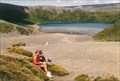
 view gallery view galleryW12.1 km |  Rangipo Desert, Central Plateau. North Is. New Zealand. Rangipo Desert, Central Plateau. North Is. New Zealand.
in Places of Geologic Significance Rangipo Desert in the centre of the North Island is created not by a lack of rainfall, but from volcanic ash, high altitude, and associated harsh weather conditions. posted by: Punga and Paua location: North Island, New Zealand date approved: 07/27/2015 last visited: 07/27/2015 |
 view gallery view galleryN12.2 km |  Tongariro River. New Zealand. Tongariro River. New Zealand.
in Canoe/Kayak Trips Paddle down the rapids on the Tongariro River for an exciting kayaking experience that you’ll never forget. Enjoy this beautifully scenic river with its world renowned crystal clear waters and abundance of rainbow trout. posted by: Punga and Paua location: North Island, New Zealand date approved: 09/25/2009 last visited: 11/13/2010 |
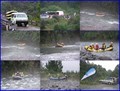 view gallery view galleryN12.2 km | Go White Water Rafting down a Wild River. in Photo Goals If you're looking for an ACTION Photo Goal, why not go White Water Rafting down a Wild River with Rapids, in a rubber raft, paddling your heart out!!! posted by: Punga and Paua location: North Island, New Zealand date approved: 03/15/2021 last visited: 01/18/2023 |
 view gallery view galleryW12.7 km | Tukino Scenic Overlook. Mt Ruapehu. North Is. New Zealand. in Scenic Overlooks A walk up Mt Ruapehu to the Tukino Ski Field will reward you with stunning views of the mountains of the Central North Island and Tongariro National Park from above the Desert Road. posted by: Punga and Paua location: North Island, New Zealand date approved: 03/13/2017 last visited: 03/14/2017 |
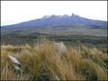
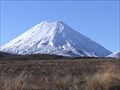 view gallery view gallery NW15.4 km NW15.4 km
|  Mt Ngauruhoe. North Island. New Zealand. Mt Ngauruhoe. North Island. New Zealand.
in Mountain Summits Mt Ngauruhoe is the almost perfect symmetrical cone-shaped volcano in Tongariro National Park in the Central North Island. posted by: Punga and Paua location: North Island, New Zealand date approved: 06/05/2009 last visited: 03/08/2024 |
 view gallery view galleryNW15.6 km |  Mt Ngauruhoe. North Island. New Zealand. Mt Ngauruhoe. North Island. New Zealand.
in Volcano Watching Mt Ngauruhoe is around 2,500 years old and is the youngest of the three volcanoes in the Tongariro National Park. On average Mt Ngauruhoe has erupted once in every nine years however the last major eruption took place in 1975. posted by: Punga and Paua location: North Island, New Zealand date approved: 07/23/2008 last visited: 03/08/2024 |
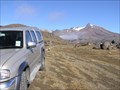 view gallery view galleryW15.8 km |  Tukino Road. Mt Ruapehu. New Zealand. Tukino Road. Mt Ruapehu. New Zealand.
in Offroad Trails The Tukino Road leading up to the Tukino Skifield is a rough rocky 4WD road up the side of a volcano, Mt Ruapehu. posted by: Punga and Paua location: North Island, New Zealand date approved: 09/23/2009 last visited: 12/01/2010 |
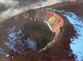
 view gallery view galleryNW15.9 km |  "Fear at Tongariro". Mt Tongariro. Nth Is. New Zealand. "Fear at Tongariro". Mt Tongariro. Nth Is. New Zealand.
in News Article Locations The front page news item in our local newspaper reported the recent eruption of Te Maari Craters on Mt Tongariro. posted by: Punga and Paua location: North Island, New Zealand date approved: 01/29/2013 last visited: 03/08/2024 |
 view gallery view galleryW16.3 km | Tama Lakes Lookout. Tongariro National Park. North Is. New Zealand. in Scenic Overlooks A 5-6 hr return walk across undulating tussock land will take you to this stunning viewpoint of the Lower Tama Lake on the Tama Lakes track at the saddle between Mt Ruapehu and Mt Ngauruhoe. posted by: Punga and Paua location: North Island, New Zealand date approved: 07/29/2020 last visited: 07/29/2020 |
 view gallery view galleryNW16.4 km | 'You are here" on the Tongariro Corssing (New Zealand) in 'You Are Here' Maps A Sign that is along the Tongariro Alpine Crossing.
The sign is also used in a Earthcache called Ngaruhoe - Mt Doom GC24VXZ posted by: nzkeko location: North Island, New Zealand date approved: 02/18/2012 last visited: 03/08/2024 |
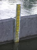 view gallery view galleryN17.5 km |  Poutu Dam River Gauge. Rotoaira. New Zealand. Poutu Dam River Gauge. Rotoaira. New Zealand.
in River Gauges A river gauge at the Poutu Dam measures water levels in the Rotoaira Channel at Lake Rotoaira. posted by: Punga and Paua location: North Island, New Zealand date approved: 09/13/2009 last visited: 11/13/2010 |
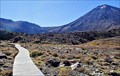 view gallery view galleryNW18 km |  Tongariro Crossing Boardwalk, Central North Island. New Zealand. Tongariro Crossing Boardwalk, Central North Island. New Zealand.
in Non-Coastal Boardwalks This section of Boardwalk forms part of the famous great walk, The Tongariro Crossing, which crosses the volcanic Tongariro National Park in the centre of the North Island. posted by: Punga and Paua location: North Island, New Zealand date approved: 11/07/2019 last visited: 03/08/2024 |
|