 view gallery view gallery NW4 km NW4 km
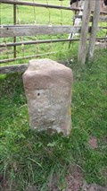
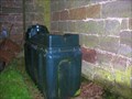
|   Brough Parish Boundary stones #7, #8 and #9 Brough Parish Boundary stones #7, #8 and #9
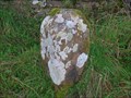
in Public Land Survey Marks There are three stone posts within sight of each other. Each with a number chiselled on. The coordinates are for number 7. posted by:  flipflopnick flipflopnick location: North West England, United Kingdom date approved: 07/03/2010 last visited: never |
 view gallery view gallery S4.7 km S4.7 km
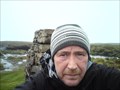
|  Nine Standards Rigg Nine Standards Rigg
in Mountain Summits Nine Standards Rigg is the summit of Hartley Fell, a fell in the Pennine Hills of England. It lies near to the boundary between Cumbria and North Yorkshire, a few miles south-east of Kirkby Stephen and approx 700 metres outside the Yorkshire Dales National Park. posted by:  grufftymilo grufftymilo location: North West England, United Kingdom date approved: 08/16/2010 last visited: 06/02/2013 |
 view gallery view gallery W4.8 km W4.8 km
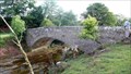
|  Belah Bridge, Cumbria (A685) Belah Bridge, Cumbria (A685)
in Stone Bridges Belah Bridge used to take the A685 road across Belah river. Another bridge does that now that road has been straightened. posted by: flipflopnick location: North West England, United Kingdom date approved: 07/05/2010 last visited: never |
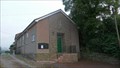 view gallery view galleryNW5 km |  Brough Sowerby Methodist Church, Cumbria Brough Sowerby Methodist Church, Cumbria
in Methodist Churches Brough Sowerby is another part of the greater parish of Church Brough, the original civil area. The A685 runs past the village. posted by: flipflopnick location: North West England, United Kingdom date approved: 07/03/2010 last visited: never |
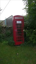 view gallery view galleryNW5 km |  Black Bull Inn RTB, Brough Sowerby, Cumbria Black Bull Inn RTB, Brough Sowerby, Cumbria
in Red Telephone Boxes This red telephone kiosk is hidden amongst the trees and bushes, beside the Black Bull Inn at Brough Sowerby on A685. posted by: flipflopnick location: North West England, United Kingdom date approved: 07/02/2010 last visited: never |
 view gallery view galleryNW5.6 km |  Brough Church, Cumbria Brough Church, Cumbria
in Photos Then and Now Brough church is unusual through the floor sloping gently down away from the altar. You are looking at the original south wall built in Norman times. Looking north west. posted by: flipflopnick location: North West England, United Kingdom date approved: 12/25/2008 last visited: never |
 view gallery view galleryNW5.6 km |  Cut Bench mark on Building at Lanehead Farm on B6276 near Brough in Cumbria Cut Bench mark on Building at Lanehead Farm on B6276 near Brough in Cumbria
in U.K. and Ireland Trigpoints Cut benchmark on corner of building near gate into Lanehead Farm on B6276 near Brough in Cumbria. posted by: Sir Lose-a-lot location: United Kingdom date approved: 08/13/2008 last visited: 08/13/2008 |
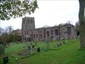
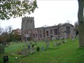 view gallery view galleryNW5.6 km |  St Michael's, Church Brough, Cumbria St Michael's, Church Brough, Cumbria
in This Old Church St Michael's church is in the southwestern part of Church Brough. The northern part of the original village gained a market charter. Now called Market Brough, leaving the lower part as Church Brough. posted by: flipflopnick location: North West England, United Kingdom date approved: 12/18/2008 last visited: 07/22/2010 |
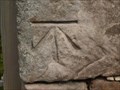
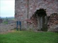
 view gallery view galleryNW5.6 km | St Michael's 1GL Bolt, Church Brough, Cumbria in U.K. and Ireland Trigpoints A first geodetic levelling bolt hiding behind the green plastic oil tank of St Michael's church, Church Brough. The mark was placed between 1840-60. Coordinates are within 3-4 metres due to poor signal. posted by: flipflopnick location: North West England, United Kingdom date approved: 12/18/2008 last visited: never |
 view gallery view galleryNW5.8 km | 1 GL bolt at Brough Castle, Cumbria in U.K. and Ireland Trigpoints This mark from the first primary levelling (1840-60) is above a free standing sign on the Clifford Tower at Brough Castle. posted by: flipflopnick location: North West England, United Kingdom date approved: 11/12/2008 last visited: never |
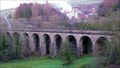 view gallery view galleryW5.8 km | Merrygill Viaduct, Hartley, Cumbria in Stone Bridges Merrygill Viaduct carried the Stainmore railway across the ravine of Hartley Beck, in Kirkby Stephen, Cumbria. The viaduct is now in the care of the Northern Viaduct Trust who allow access for all. posted by: flipflopnick location: North West England, United Kingdom date approved: 01/22/2012 last visited: never |
 view gallery view galleryW5.8 km |  Merrygill Viaduct, Hartley, Kirkby Stephen, Cumbria Merrygill Viaduct, Hartley, Kirkby Stephen, Cumbria
in Arch Bridges Merrygill Viaduct has nine arches spanning 366 feet, about 30 feet per arch. The track bed is now a public access area, in the care of the Northern Viaduct Trust. posted by: flipflopnick location: North West England, United Kingdom date approved: 01/22/2012 last visited: never |
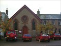 view gallery view galleryNW5.8 km | Brough Methodist Church, Cumbria in This Old Church Brough Methodist church is on the main street through the market town, with parking in front. Along B6276 on East side of the town. posted by: flipflopnick location: North West England, United Kingdom date approved: 12/13/2008 last visited: 07/22/2010 |
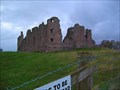 view gallery view galleryNW5.8 km |  Brough Castle, Cumbria Brough Castle, Cumbria
in Castles Brough Castle is on south west outskirts of Church Brough village. A short walk along paved path to English Heritage protected ruin. posted by: flipflopnick location: North West England, United Kingdom date approved: 11/12/2008 last visited: never |
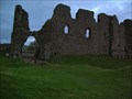 view gallery view galleryNW5.8 km |  Brough Castle Brough Castle
in Wikipedia Entries Brough Castle is now ruined, and stands close by, to the south west of Church Brough. It is in the care of English Heritage. Free entry and parking. Nearby tea shop. posted by: flipflopnick location: North West England, United Kingdom date approved: 11/14/2008 last visited: never |
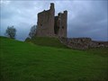 view gallery view galleryNW5.8 km |  Brough Castle Brough Castle
in English Heritage - Cadw - Historic Scotland Brough Castle is now a ruin with impressive walls showing its former imposing glory. Free entry and parking. posted by: flipflopnick location: North West England, United Kingdom date approved: 11/12/2008 last visited: never |
 view gallery view galleryNW6 km | Flush Bracket 11753 Brough Old Bridge, Cumbria in U.K. and Ireland Trigpoints A flush bracket on road side of end column on downstream side of bridge. Interesting saddle type flower boxes on fence railing. posted by: flipflopnick location: North West England, United Kingdom date approved: 11/14/2008 last visited: 07/22/2010 |
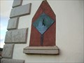 view gallery view galleryNW6 km |  John Thompson Esqr Sundial, Brough, Cumbria John Thompson Esqr Sundial, Brough, Cumbria
in Sundials This sundial is on a house in Brough Main Street, on the east side bank of Swindale Beck. posted by: flipflopnick location: North West England, United Kingdom date approved: 12/24/2008 last visited: 07/22/2010 |
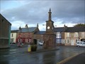 view gallery view galleryNW6 km |  Coronation Clock Tower, Brough, Cumbria Coronation Clock Tower, Brough, Cumbria
in Town Clocks The Clock tower is the most prominent building in the village, and was erected to commemorate the coronation of King George V. posted by: flipflopnick location: North West England, United Kingdom date approved: 12/14/2008 last visited: 07/22/2010 |
 view gallery view galleryNW6 km | Brough, Cumbria in Wikipedia Entries Brough describes two villages. Market Brough the northern one granted a market charter. Church Brough, the southern part with the castle ruins and church. posted by: flipflopnick location: North West England, United Kingdom date approved: 12/19/2008 last visited: 07/22/2010 |
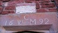 view gallery view galleryW6 km |  1692 - Wearcot, Hartley, Cumbria 1692 - Wearcot, Hartley, Cumbria
in Dated Buildings and Cornerstones Wearcot is an old house built of red sandstone on the south east side of Hartley Beck, on the road to Hartley Castle farm. posted by: flipflopnick location: North West England, United Kingdom date approved: 03/04/2012 last visited: never |
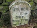 view gallery view galleryNW6 km |  Brough 1 Middleton 13 milestone, Cumbria Brough 1 Middleton 13 milestone, Cumbria
in Milestones The first milestone along the old turnpike route between Brough and Middleton-in-Teesdale. posted by: flipflopnick location: North West England, United Kingdom date approved: 12/23/2008 last visited: never |
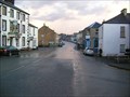
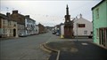 view gallery view galleryNW6 km | Brough Main Street, Cumbria in Photos Then and Now You are looking east along the main road through Market Brough at the iconic clock tower at the junction of B6276. posted by: flipflopnick location: North West England, United Kingdom date approved: 12/25/2008 last visited: 07/22/2010 |
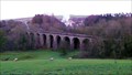 view gallery view galleryW6 km |  Merrygill Viaduct, Kirkby Stephen, Cumbria Merrygill Viaduct, Kirkby Stephen, Cumbria
in Railroad Bridges Merrygill Viaduct is in the care of the Northern Viaduct Trust, who allow unrestricted access to the line for walkers and cyclists. The old line is a popular walkway between Hartley and Stenkrith. posted by: flipflopnick location: North West England, United Kingdom date approved: 01/22/2012 last visited: never |
 view gallery view galleryNW6 km | Hazel Bank Boundary Stone, B6276, Cumbria in Public Land Survey Marks The worked stone marks the division between Stainmore and Brough townships. The stone is on the outside of a slight bend, raised up on a bank. posted by: flipflopnick location: North West England, United Kingdom date approved: 12/13/2008 last visited: 07/21/2010 |
|