 view gallery view gallery N5.8 km N5.8 km
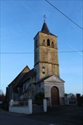
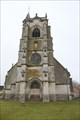
|   Le Clocher de l'Église Saint-Martin - Gouy-Saint-André, France Le Clocher de l'Église Saint-Martin - Gouy-Saint-André, France
in Bell Towers [EN] The Saint-Martin church is a white stone building from the 15th or 16th century, which consists of a choir, a nave of two spans, and a tower. [FR] L'église Saint-Martin est un édifice en pierre blanche du XVe ou XVIe siècle, qui se compose d'un chœur, d'une nef de deux travées, et d'une tour. posted by:  pmaupin pmaupin location: Hauts-de-France, France date approved: 01/30/2020 last visited: 01/30/2020 |
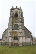
 view gallery view galleryN5.8 km |  Église Saint-Martin - Gouy-Saint-André, France Église Saint-Martin - Gouy-Saint-André, France
in Medieval Churches [EN] The Saint-Martin church is a white stone building from the 15th or 16th century, which consists of a choir, a nave of two spans, and a tower. [FR] L'église Saint-Martin est un édifice en pierre blanche du XVe ou XVIe siècle, qui se compose d'un chœur, d'une nef de deux travées, et d'une tour. posted by: pmaupin location: Hauts-de-France, France date approved: 01/30/2020 last visited: 01/30/2020 |
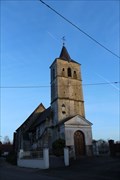 view gallery view galleryN5.8 km |  Église Saint-Martin - Gouy-Saint-André, France Église Saint-Martin - Gouy-Saint-André, France
in This Old Church [EN] The Saint-Martin church is a white stone building from the 15th or 16th century, which consists of a choir, a nave of two spans, and a tower. [FR] L'église Saint-Martin est un édifice en pierre blanche du XVe ou XVIe siècle, qui se compose d'un chœur, d'une nef de deux travées, et d'une tour. posted by: pmaupin location: Hauts-de-France, France date approved: 01/30/2020 last visited: 01/30/2020 |
 view gallery view galleryN5.8 km | Église Saint-Martin - Gouy-Saint-André, France in Roman Catholic Churches [EN] The Saint-Martin church is a white stone building from the 15th or 16th century, which consists of a choir, a nave of two spans, and a tower.
[FR] L'église Saint-Martin est un édifice en pierre blanche du XVe ou XVIe siècle, qui se compose d'un chœur, d'une nef de deux travées, et d'une tour. posted by: pmaupin location: Hauts-de-France, France date approved: 01/30/2020 last visited: 01/30/2020 |
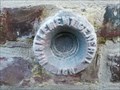
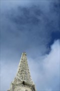
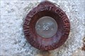 view gallery view galleryN5.8 km |  Benchmark - Église Saint-Martin - Gouy-Saint-André, France Benchmark - Église Saint-Martin - Gouy-Saint-André, France
in French Benchmarks Le Repère Cylindrique du Nivellement Général se situe sur le mur de façade nord-ouest de l'église. posted by: pmaupin location: Hauts-de-France, France date approved: 01/30/2020 last visited: 01/30/2020 |
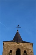 view gallery view galleryN5.8 km | Benchmark - Point Géodésique - Église Saint-Martin - Gouy-Saint-André, France in French Benchmarks Repère géodésique du point 1, au centre de la croix du clocher de l'église avec un Azimut de la prise de vue égal à 178 gr. posted by: pmaupin location: Hauts-de-France, France date approved: 01/30/2020 last visited: 01/30/2020 |
 view gallery view gallery S7.4 km S7.4 km
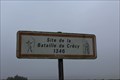
|  Bataille de Crécy - Crécy-en-Ponthieu - Somme - France Bataille de Crécy - Crécy-en-Ponthieu - Somme - France
in Battlefields [EN] On 26 August 1346 the battle of Crécy opposed the army of the kingdom of France to an army from England.
[FR] La bataille de Crécy opposa le 26 août 1346 l'armée du royaume de France à une armée venue d'Angleterre. posted by: pmaupin location: Hauts-de-France, France date approved: 12/18/2016 last visited: 12/18/2016 |
 view gallery view gallery W7.4 km W7.4 km
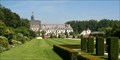
|  Jardins de Valloires, Argoules, France Jardins de Valloires, Argoules, France
in Botanical Gardens 8 ha of plants and flowers in a huge park near the abbey of Valloires. posted by: DeepPurple location: France date approved: 08/28/2006 last visited: 08/28/2022 |
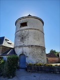 view gallery view galleryW7.7 km |  Pigeonnier de l’Abbaye de Valloires - Argoules, France Pigeonnier de l’Abbaye de Valloires - Argoules, France
in Dovecotes [FR] L'abbaye de Valloires est une fondation cistercienne du xiie siècle. [EN] Valloires Abbey is a 12th-century Cistercian abbey situated in the commune of Argoules. posted by: RakeInTheCache location: Hauts-de-France, France date approved: 08/29/2022 last visited: never |
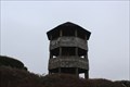 view gallery view galleryS7.7 km |  Tour de Guêt - Crécy, France Tour de Guêt - Crécy, France
in Look-Out Towers [EN] Since 1984, a lookout tower allows to observe the panorama of the battlefield.
[FR] Depuis 1984, une tour de guet permet d'observer le panorama du champ de bataille. posted by: pmaupin location: Hauts-de-France, France date approved: 03/22/2017 last visited: 01/16/2017 |
 view gallery view galleryS8.4 km | Église Saint-Séverin - Crécy-en-Ponthieu - France in This Old Church [EN] The church of Saint-Séverin de Crécy-en-Ponthieu is a Catholic church located in Crécy-en-Ponthieu, in the department of the Somme.
[FR] L'église Saint-Séverin de Crécy-en-Ponthieu est une église catholique située à Crécy-en-Ponthieu, dans le département de la Somme. posted by: pmaupin location: Hauts-de-France, France date approved: 01/31/2017 last visited: 01/31/2017 |
 view gallery view galleryS8.4 km | Église Saint-Séverin - Crécy-en-Ponthieu, France in Roman Catholic Churches [EN] The Saint-Séverin church is dated from the 15th century, it seems that the oldest part, the tower, dates back to the 14th century, at the time of the battle of Crécy (1346). [FR] L’église Saint-Séverin est datée du XVe siècle, il semble que la partie la plus ancienne, la tour, remonte au XIVe siècle, à l’époque de la bataille de Crécy (1346). posted by: pmaupin location: Hauts-de-France, France date approved: 01/22/2020 last visited: 01/22/2016 |
 view gallery view galleryS8.4 km | Église Saint-Séverin - Crécy-en-Ponthieu, France in Medieval Churches [EN] The Saint-Séverin church is dated from the 15th century, it seems that the oldest part, the tower, dates back to the 14th century, at the time of the battle of Crécy (1346). [FR] L’église Saint-Séverin est datée du XVe siècle, il semble que la partie la plus ancienne, la tour, remonte au XIVe siècle, à l’époque de la bataille de Crécy (1346). posted by: pmaupin location: Hauts-de-France, France date approved: 01/21/2020 last visited: 12/18/2016 |
 view gallery view galleryS8.4 km |  Église Saint-Séverin - Crécy-en-Ponthieu, France Église Saint-Séverin - Crécy-en-Ponthieu, France
in Wikipedia Entries [EN] The Saint-Séverin church is dated from the 15th century, it seems that the oldest part, the tower, dates back to the 14th century, at the time of the battle of Crécy (1346).
[FR] L’église Saint-Séverin est datée du XVe siècle, il semble que la partie la plus ancienne, la tour, remonte au XIVe siècle, à l’époque de la bataille de Crécy (1346). posted by: pmaupin location: Hauts-de-France, France date approved: 01/21/2020 last visited: 12/18/2016 |
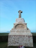 view gallery view galleryS8.9 km |  La Croix de Bohême - Estrées-les-Crécy, France La Croix de Bohême - Estrées-les-Crécy, France
in Christian Crosses [EN] In the place where the old Bohemian king fell, in front of Crécy, on his way to Fontaine-sur-Maye, a small tuff cross was erected.
[FR] A l’endroit, où le vieux roi de Bohême est tombé, en avant de Crécy, en se dirigeant vers Fontaine-sur-Maye, on a érigé une petite croix en tuf. posted by: pmaupin location: Hauts-de-France, France date approved: 01/26/2020 last visited: 01/19/2020 |
 view gallery view galleryS8.9 km | Benchmark - Croix de Roi de Bohême - Crécy en Ponthieu, France in French Benchmarks Le Repère Cylindrique du Nivellement Général se situe sur le socle, sur la face opposée à la route. posted by: pmaupin location: Hauts-de-France, France date approved: 01/27/2020 last visited: 01/27/2020 |
 view gallery view gallery SW9.5 km SW9.5 km
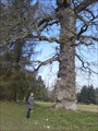
|  Chêne des Ramolleux - Forêt de Crécy - France Chêne des Ramolleux - Forêt de Crécy - France
in Exceptional Trees [EN] Oak forest of Crécy, classified remarkable tree
[FR] Chêne de la forêt de Crécy, classé arbre remarquable posted by: pmaupin location: Hauts-de-France, France date approved: 08/23/2016 last visited: 03/14/2015 |
 view gallery view gallery NE9.8 km NE9.8 km
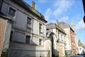
|  Ancien hospice Saint-Jean, puis collège des Jésuites - Hesdin, France Ancien hospice Saint-Jean, puis collège des Jésuites - Hesdin, France
in Monuments Historiques Français [FR] Les jésuites construisant en 1617 un collège qui fut fermé en 1762. L’hospice intégra en 1770 les bâtiments du collège. Vers 1880, Clovis Normand édifia la chapelle.
[EN] The Jesuits built in 1617 a college which was closed in 1762. The hospice integrated in 1770 the college buildings. Around 1880, Clovis Normand built the chapel. posted by: pmaupin location: Hauts-de-France, France date approved: 02/01/2020 last visited: 02/01/2020 |
 view gallery view galleryNE9.8 km | Benchmark - Point Géodésique - Beffroi d'Hesdin - Hesdin, France in French Benchmarks Repère géodésique du point 1, Base de la Girouette et sommet du renflement du Beffroi, avec un Azimut de la prise de vue égal à 292 gr. posted by: pmaupin location: Hauts-de-France, France date approved: 01/31/2020 last visited: 01/31/2020 |
 view gallery view galleryNE9.8 km | Le Beffroi d'Hesdin - Hesdin, France in Bell Towers [EN] The belfry of Hesdin is a quadrangular stone tower with a square base which rises on three levels of equal dimensions. [FR] Le beffroi d'Hesdin est une tour de pierre quadrangulaire de base carrée qui s'élève sur trois niveaux d'égales dimensions. posted by: pmaupin location: Hauts-de-France, France date approved: 01/31/2020 last visited: 07/20/2020 |
 view gallery view galleryNE9.8 km |  Hesdin - France Hesdin - France
in City and Town Halls [EN] Hesdin is a French commune located in the department of Pas-de-Calais in the Hauts-de-France region.
[FR] Hesdin est une commune française située dans le département du Pas-de-Calais en région Hauts-de-France. posted by: pmaupin location: Hauts-de-France, France date approved: 02/03/2020 last visited: 01/22/2020 |
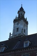 view gallery view galleryNE9.8 km | Beffroi d'Hesdin - Hesdin, France in Wikipedia Entries [EN] The belfry of Hesdin is a quadrangular stone tower with a square base which rises on three levels of equal dimensions.
[FR] Le beffroi d'Hesdin est une tour de pierre quadrangulaire de base carrée qui s'élève sur trois niveaux d'égales dimensions. posted by: pmaupin location: Hauts-de-France, France date approved: 01/30/2020 last visited: 07/20/2020 |
 view gallery view galleryNE9.8 km |  Belfries of Belgium and France - Beffroi - Hesdin, France, ID=943-049 Belfries of Belgium and France - Beffroi - Hesdin, France, ID=943-049
in World Heritage Sites [EN] The belfry of Hesdin is a quadrangular stone tower with a square base which rises on three levels of equal dimensions. [FR] Le beffroi d'Hesdin est une tour de pierre quadrangulaire de base carrée qui s'élève sur trois niveaux d'égales dimensions. posted by: pmaupin location: Hauts-de-France, France date approved: 01/30/2020 last visited: 07/20/2020 |
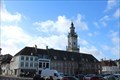 view gallery view galleryNE9.8 km | Hôtel de ville de Hesdin - Hesdin, France in Monuments Historiques Français [FR] L'hôtel de ville des XVIe et XVIIe siècles, restauré au XIXe siècle grâce à un don de Pierre Lereuil, comprenant une bretèche du XVIIe siècle réalisée par Jacques Bidan, Pierre Guimopre et Roussel.
[EN] The town hall of the 16th and 17th centuries, restored in the 19th century thanks to a donation from Pierre Lereuil, including a 17th century bretèche made by Jacques Bidan, Pierre Guimopre and Roussel. posted by: pmaupin location: Hauts-de-France, France date approved: 02/03/2020 last visited: 07/20/2020 |
 view gallery view galleryNE10 km | Benchmark - Point Géodésique - Clocher de la Chapelle de l'Hospice - Hesdin, France in French Benchmarks Repère géodésique du point b, au centre de la croix du Clocher de la Chapelle de l'Hospice, avec un Azimut de la prise de vue égal à 340 gr. posted by: pmaupin location: Hauts-de-France, France date approved: 02/01/2020 last visited: 02/01/2020 |
|