 view gallery view gallery SW7.4 km SW7.4 km
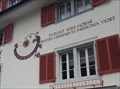
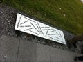
|   Sundial at Rütli-Apotheke, Brunnen, SZ, Switzerland Sundial at Rütli-Apotheke, Brunnen, SZ, Switzerland
in Sundials A sundial at a pharmacie in the center of Brunnen. posted by:  fi67 fi67 location: Schwyz, Switzerland date approved: 06/21/2022 last visited: never |
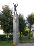
 view gallery view gallerySW7.4 km |  Schwyzer Bergbauer - Brunnen, SZ, Switzerland Schwyzer Bergbauer - Brunnen, SZ, Switzerland
in Occupational Monuments A fountain by the sculptor Josef Bisa in the center of Brunnen dedicated to the local mountain farmer. posted by: fi67 location: Schwyz, Switzerland date approved: 06/11/2022 last visited: never |
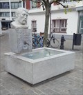
 view gallery view gallerySW7.4 km |  Brunnen Schwyzer Bergbauer - Brunnen, SZ, Switzerland Brunnen Schwyzer Bergbauer - Brunnen, SZ, Switzerland
in Fountains A fountain in the center of Brunnen with a bust of a local mountain farmer by the sculptor Josef Bisa. posted by: fi67 location: Schwyz, Switzerland date approved: 06/08/2022 last visited: never |
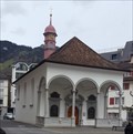 view gallery view gallerySW7.4 km |  Bundeskapelle - Brunnen, SZ, Switzerland Bundeskapelle - Brunnen, SZ, Switzerland
in Roman Catholic Churches A 17th century chapel in the location where the second federal oath of the Old Swiss Confederacy is said to have taken place in 1315. posted by: fi67 location: Schwyz, Switzerland date approved: 06/07/2022 last visited: never |
 view gallery view gallerySW7.4 km |  Bundeskapelle - Brunnen, SZ, Switzerland Bundeskapelle - Brunnen, SZ, Switzerland
in Austrian and Swiss National Heritage Sites A 17th century chapel in the location where the second federal oath of the Old Swiss Confederacy is said to have taken place in 1315. posted by: fi67 location: Schwyz, Switzerland date approved: 06/07/2022 last visited: never |
 view gallery view gallerySW7.4 km |  Bundeskapelle - Brunnen, SZ, Switzerland Bundeskapelle - Brunnen, SZ, Switzerland
in Official Local Tourism Attractions A 17th century chapel in the location where the second federal oath of the Old Swiss Confederacy is said to have taken place in 1315. posted by: fi67 location: Schwyz, Switzerland date approved: 06/04/2022 last visited: never |
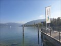
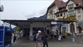 view gallery view gallerySW7.6 km |  Schiffsanlegestelle - Brunnen, SZ, Switzerland Schiffsanlegestelle - Brunnen, SZ, Switzerland
in Ferries and Ferry Landings The ferry landing of Brunnen in the northeast of Lake Lucerne. posted by: fi67 location: Schwyz, Switzerland date approved: 06/11/2022 last visited: never |
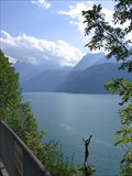 view gallery view gallerySW7.7 km |  Urner See Overlook Urner See Overlook
in Scenic Roadside Look-Outs A scenic overlook of the beautiful mountain lake Urner See along the south bound A4 highway. posted by: RakeInTheCache location: Schwyz, Switzerland date approved: 08/30/2007 last visited: 01/03/2010 |
 view gallery view gallery SE8.5 km SE8.5 km
|  The Blackest Day The Blackest Day
in Plane Crash Sites 27 August 1938 was the blackest day in the history of the Swiss Air Force. posted by: RakeInTheCache location: Schwyz, Switzerland date approved: 09/13/2007 last visited: never |
 view gallery view gallery W10.8 km W10.8 km
|  Arth-Goldau, SZ, Switzerland Arth-Goldau, SZ, Switzerland
in Train Stations/Depots Arth-Goldau is an important railway junction south of Lake Zug. posted by: fi67 location: Schwyz, Switzerland date approved: 08/19/2013 last visited: 02/15/2017 |
 view gallery view gallery NW14.2 km NW14.2 km
| Unterageri - Zug, Switzerland in Ferries and Ferry Landings This is the ferry pier in Unterageri, near Zug, capital of the canton with the same name. posted by: Torgut location: Zug, Switzerland date approved: 10/26/2021 last visited: never |
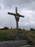 view gallery view gallery S14.5 km S14.5 km
|  Eggberge Cross Eggberge Cross
in Christian Crosses A cross erected high above the Urnersee in central Switzerland. posted by: RakeInTheCache location: Uri, Switzerland date approved: 08/29/2007 last visited: never |
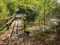 view gallery view galleryNW15.3 km |  Zugerberg to Unterageri - Zug, Switzerland Zugerberg to Unterageri - Zug, Switzerland
in Hiking Path Footbridges This bridge is located on the trail connecting Zugerberg and Unterageri, in Zug area. posted by: Torgut location: Zug, Switzerland date approved: 10/24/2021 last visited: never |
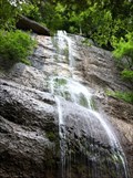 view gallery view galleryW15.3 km |  Gruebisbalm-Wasserfall - Vitznau, LU, Switzerland Gruebisbalm-Wasserfall - Vitznau, LU, Switzerland
in Waterfalls A waterfall at the southern slope of Mount Rigi with a natural cave behind it. posted by: fi67 location: Luzern, Switzerland date approved: 08/11/2012 last visited: 03/12/2017 |
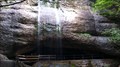 view gallery view galleryW15.3 km | ") Gruebisbalm-Höhle - Vitznau, LU, Switzerland Gruebisbalm-Höhle - Vitznau, LU, Switzerland
in Cave Entrances (Natural) A cave behind a waterfall at the southern slope of Mount Rigi. posted by: fi67 location: Luzern, Switzerland date approved: 08/13/2012 last visited: never |
 view gallery view galleryW15.8 km |  Direction and Distance Plate at Rigi Kulm - Switzerland Direction and Distance Plate at Rigi Kulm - Switzerland
in Direction and Distance Arrows A ground plate near the summit of Mount Rigi shows the directions and distances to some of the world's major cities. posted by: fi67 location: Schwyz, Switzerland date approved: 09/17/2011 last visited: 08/08/2015 |
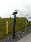 view gallery view galleryW15.8 km |  Binocular at Rigi Kulm - Switzerland Binocular at Rigi Kulm - Switzerland
in Coin-Op Binoculars A binocular at the peak of Mount Rigi posted by: fi67 location: Schwyz, Switzerland date approved: 09/13/2011 last visited: 08/08/2015 |
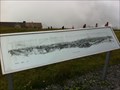 view gallery view galleryW15.8 km |  Orientation Table at Rigi Kulm - Switzerland Orientation Table at Rigi Kulm - Switzerland
in Orientation Tables An orientation table at the peak of Mount Rigi in Central Switzerland posted by: fi67 location: Schwyz, Switzerland date approved: 09/18/2011 last visited: 05/14/2015 |
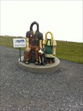 view gallery view galleryW15.8 km |  Mountain Herdsman, Girl and Dog at Rigi Kulm - Switzerland Mountain Herdsman, Girl and Dog at Rigi Kulm - Switzerland
in Photo Cutouts This fiberglass photo cutout of a traditional mountain herdsman and a girl is located near the summit of Mount Rigi. posted by: fi67 location: Schwyz, Switzerland date approved: 09/13/2011 last visited: 05/14/2015 |
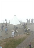
 view gallery view galleryW15.8 km |  Rigi Kulm - Arth, SZ, Switzerland Rigi Kulm - Arth, SZ, Switzerland
in Geographic High Points The summit of Mount Rigi - called Rigi Kulm - is the highest point of the municipality of Arth. posted by: fi67 location: Schwyz, Switzerland date approved: 09/19/2012 last visited: 05/14/2015 |
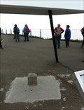
 view gallery view galleryW15.8 km |  N 47° 03' 28.9566" E 8° 29' 11.1113" - Rigi, Switzerland N 47° 03' 28.9566" E 8° 29' 11.1113" - Rigi, Switzerland
in Permanent Geographic Coordinates Coordinates on a table at the triangulation point of Mount Rigi. posted by: fi67 location: Schwyz, Switzerland date approved: 09/13/2011 last visited: 05/14/2015 |
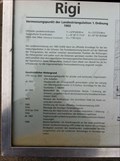
 view gallery view galleryW15.8 km |  Vermessungspunkt Rigi - Switzerland Vermessungspunkt Rigi - Switzerland
in European Historic Survey Stones, Monuments and Benchmarks A first level triangulation point at the summit of Mount Rigi. posted by: fi67 location: Schwyz, Switzerland date approved: 09/13/2011 last visited: 10/22/2016 |
 view gallery view galleryW15.8 km |  Rigi Kulm - Switzerland Rigi Kulm - Switzerland
in Mountain Summits Rigi, also known as the "Queen of the mountains" is located north of Lake Lucerne. The highest peak is 1797.5 meters above sea level at Rigi Kulm. posted by: fi67 location: Schwyz, Switzerland date approved: 09/15/2011 last visited: 10/22/2016 |
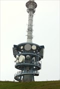 view gallery view galleryW15.8 km |  Sender Rigi - Arth, SZ, Switzerland Sender Rigi - Arth, SZ, Switzerland
in Radio and Television Transmitter Towers The television and radio transmitter tower on the top of Mount Rigi. posted by: fi67 location: Schwyz, Switzerland date approved: 04/11/2017 last visited: 10/22/2016 |
 view gallery view galleryW15.8 km |  Sendestation Rigi Kulm - Switzerland Sendestation Rigi Kulm - Switzerland
in Look-Out Towers The transmission tower on the top of Mount Rigi has an observation platform. posted by: fi67 location: Schwyz, Switzerland date approved: 09/12/2011 last visited: 10/22/2016 |
|