 view gallery view gallery E7.1 km E7.1 km
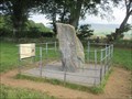
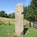
|   The Picardy Stone - Aberdeenshire, Scotland. The Picardy Stone - Aberdeenshire, Scotland.
in Megalithic Monuments Pictish symbol stone on top of a burial site, dating from the 6th or 7th century, in a field two miles north-west of the Aberdeenshire town of Insch. posted by:  creg-ny-baa creg-ny-baa location: Northern Scotland, United Kingdom date approved: 07/18/2021 last visited: never |
 view gallery view galleryE7.1 km |  The Picardy Stone - Aberdeenshire, Scotland. The Picardy Stone - Aberdeenshire, Scotland.
in English Heritage - Cadw - Historic Scotland Pictish Symbol Stone, dating back to the 6th or 7th century, situated two miles north-west of the Aberdeenshire town of Insch, and now in the care of Historic Scotland. posted by: creg-ny-baa location: Northern Scotland, United Kingdom date approved: 07/21/2021 last visited: never |
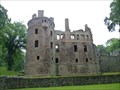
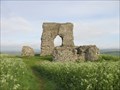 view gallery view galleryE7.2 km |  Dunnideer Castle - Aberdeenshire, Scotland. Dunnideer Castle - Aberdeenshire, Scotland.
in Preserved Architectural Remnants and Ruins Ruins of a 13th century tower house on the summit of the Hill of Dunnideer, west of the Aberdeenshire town of Insch. posted by: creg-ny-baa location: Northern Scotland, United Kingdom date approved: 07/15/2021 last visited: never |
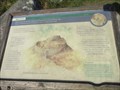
 view gallery view galleryE7.7 km |  Dunnideer Hillfort & Castle - Insch, Aberdeenshire. Dunnideer Hillfort & Castle - Insch, Aberdeenshire.
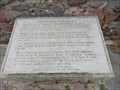
in UK Historical Markers Historical information on the iron-age hillfort and 13th century castle on the Hill of Dunnideer, overlooking the Aberdeenshire town of Insch, in north-eastern Scotland. posted by: creg-ny-baa location: Northern Scotland, United Kingdom date approved: 07/21/2021 last visited: never |
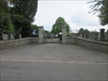 view gallery view galleryE8.4 km |  Insch New Cemetery - Aberdeenshire, Scotland. Insch New Cemetery - Aberdeenshire, Scotland.
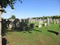
in Worldwide Cemeteries Cemetery situated on the western edge of the Aberdeenshire town of Insch. posted by: creg-ny-baa location: Northern Scotland, United Kingdom date approved: 08/12/2021 last visited: never |
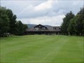
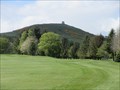 view gallery view galleryE9 km |  Insch Golf Club - Aberdeenshire, Scotland. Insch Golf Club - Aberdeenshire, Scotland.
in Public and Private Golf Courses Wooded parkland golf course in the small Aberdeenshire town of Insch. posted by: creg-ny-baa location: Northern Scotland, United Kingdom date approved: 05/13/2019 last visited: never |
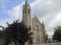 view gallery view galleryE9.2 km |  Insch Parish Church - Aberdeenshire, Scotland Insch Parish Church - Aberdeenshire, Scotland
in Presbyterian Churches The parish church in the small Aberdeenshire town of Insch, under the Church of Scotland denomination. posted by: creg-ny-baa location: Northern Scotland, United Kingdom date approved: 07/22/2021 last visited: never |
 view gallery view galleryE9.2 km |  Insch Parish Church - Aberdeenshire, Scotland. Insch Parish Church - Aberdeenshire, Scotland.
in Unique Steeples Octagonal spirelet, with clock, on the south-west corner of the parish church, in the small Aberdeenshire town of Insch, in north-eastern Scotland. posted by: creg-ny-baa location: Northern Scotland, United Kingdom date approved: 07/19/2021 last visited: never |
 view gallery view gallery N11.6 km N11.6 km
|  Huntly Castle - Huntly, Scotland, UK Huntly Castle - Huntly, Scotland, UK
in Castles Huntly Castle is a ruined castle located in Huntly in Aberdeenshire posted by:  tmob tmob location: Northern Scotland, United Kingdom date approved: 09/06/2012 last visited: never |
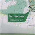
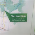 view gallery view galleryE13 km |  You Are Here - Back o'Bennachie, Aberdeenshire. You Are Here - Back o'Bennachie, Aberdeenshire.
in 'You Are Here' Maps 'You are here' in the car park at the Back o'Bennachie at the start of the trails up the popular hill in Aberdeenshire. posted by: creg-ny-baa location: Northern Scotland, United Kingdom date approved: 08/02/2018 last visited: never |
 view gallery view gallery S13.4 km S13.4 km
| Alford Golf Club - Aberdeenshire, Scotland. in Public and Private Golf Courses Flat parkland course in the small Aberdeenshire town of Alford in Scotland. posted by: creg-ny-baa location: Northern Scotland, United Kingdom date approved: 08/27/2020 last visited: never |
 view gallery view galleryS13.7 km | You Are Here - Alford, Aberdeenshire, Scotland in 'You Are Here' Maps 'You Are Here' in the village car park in Alford, a large village in the centre of rural Aberdeenshire. posted by: creg-ny-baa location: Northern Scotland, United Kingdom date approved: 10/18/2023 last visited: never |
 view gallery view gallery SE13.8 km SE13.8 km
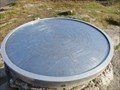
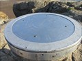
|  Oxen Craig of Bennachie Indicator - Aberdeenshire, Scotland. Oxen Craig of Bennachie Indicator - Aberdeenshire, Scotland.
in Orientation Tables Indicator on the summit of Oxen Craig, the highest point of Bennachie in Aberdeenshire, Scotland. posted by: creg-ny-baa location: Northern Scotland, United Kingdom date approved: 08/01/2018 last visited: never |
 view gallery view galleryS14 km | Aberdeen Angus - Alford, Aberdeenshire in UK Historical Markers Stone plaque detailing the significance of the life size bronze sculpture of an Aberdeen Angus Bull that stands by the roadside on the eastern approach to the large Aberdeenshire village of Alford. posted by: creg-ny-baa location: Northern Scotland, United Kingdom date approved: 10/21/2023 last visited: never |
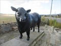 view gallery view galleryS14 km |  Aberdeen Angus Bull - Alford, Aberdeenshire, Scotland Aberdeen Angus Bull - Alford, Aberdeenshire, Scotland
in Figurative Public Sculpture Life size bronze sculpture of an Aberdeen Angus bull on the eastern approach to the Aberdeenshire village of Alford, where the breed was first established in the 1800s. posted by: creg-ny-baa location: Northern Scotland, United Kingdom date approved: 10/20/2023 last visited: never |
 view gallery view galleryE14.5 km | Oyne Old Parish Church Burial Ground - Aberdeenshire, Scotland. in Worldwide Cemeteries Burial ground at the site of the former parish church in the hamlet of the Kirkton of Oyne in Aberdeenshire, Scotland. posted by: creg-ny-baa location: Northern Scotland, United Kingdom date approved: 08/03/2018 last visited: never |
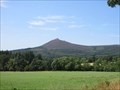 view gallery view gallerySE15.8 km |  Bennachie - Aberdeenshire, Scotland. Bennachie - Aberdeenshire, Scotland.
in Wikipedia Entries Prominent area of high ground rising out of the countryside of Aberdeenshire with historical connotations dating back to the Iron Age. posted by: creg-ny-baa location: Northern Scotland, United Kingdom date approved: 09/19/2018 last visited: never |
 view gallery view gallerySE15.8 km | Mither Tap of Bennachie Indicator - Aberdeenshire, Scotland in Orientation Tables Indicator on the rocky granite summit of Mither Tap in Aberdeenshire, Scotland. posted by: creg-ny-baa location: Northern Scotland, United Kingdom date approved: 07/30/2018 last visited: never |
 view gallery view gallerySE15.8 km | Mither Tap Pictish Fort - Aberdeenshire, Scotland. in UK Historical Markers Historical information board on the footpath just below the summit of the Mither Tap of Bennachie, outlining the details of the Pictish, or Iron Age fort, that once stood there. posted by: creg-ny-baa location: Northern Scotland, United Kingdom date approved: 07/31/2018 last visited: never |
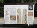 view gallery view galleryE16.9 km | The Maiden Stone - Garioch, Aberdeenshire. in UK Historical Markers Information sign next to the Maiden Stone, a Pictish standing stone dating from the 9th century. posted by: creg-ny-baa location: Northern Scotland, United Kingdom date approved: 08/27/2018 last visited: never |
 view gallery view galleryE16.9 km | The Maiden Stone - Garioch, Aberdeenshire. in English Heritage - Cadw - Historic Scotland Pictish Standing Stone dating from the 8th century, on a roadside location in the Garioch district of Aberdeenshire. posted by: creg-ny-baa location: Northern Scotland, United Kingdom date approved: 09/09/2018 last visited: never |
 view gallery view galleryE16.9 km | The Maiden Stone - Aberdeenshire, Scotland. in Megalithic Monuments Red granite standing stone in the Garioch district of Aberdeenshire, carved by the Picts 1,200 years ago. posted by: creg-ny-baa location: Northern Scotland, United Kingdom date approved: 08/05/2018 last visited: never |
 view gallery view gallerySE17.5 km | You Are Here - Bennachie Visitor Centre, Aberdeenshire. in 'You Are Here' Maps 'You are here' in the car park at Bennachie Visitor Centre in Aberdeenshire, Scotland. posted by: creg-ny-baa location: Northern Scotland, United Kingdom date approved: 07/29/2018 last visited: never |
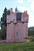 view gallery view galleryS19.8 km | Craigievar Castle - Alford, Scotland, UK in Wikipedia Entries [EN] Craigievar Castle is a pinkish harled castle or fortified country house 6 miles (9.7 km) south of Alford, Scotland.
[FR] Le château de Craigievar est un château harled rosâtre ou une maison de campagne fortifiée. posted by: pmaupin location: Northern Scotland, United Kingdom date approved: 04/29/2024 last visited: never |
 view gallery view galleryS19.8 km | Craigievar Castle - Alford, Scotland, UK in Castles [EN] Craigievar Castle is a pinkish harled castle or fortified country house 6 miles (9.7 km) south of Alford, Scotland. [FR] Le château de Craigievar est un château harled rosâtre ou une maison de campagne fortifiée. posted by: pmaupin location: Northern Scotland, United Kingdom date approved: 04/30/2024 last visited: never |
|