 view gallery view gallery SE2.9 km SE2.9 km
|   La pointe du minou. La pointe du minou.
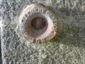
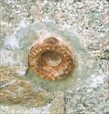
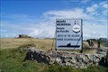
in French Benchmarks D'une altitude très précise de 25,408 m ce repère en bronze se frotte tous les jours à l'air iodé de la mer d'iroise.
posted by:  bob29 bob29 location: France date approved: 08/21/2008 last visited: never |
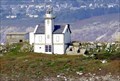
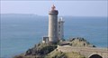 view gallery view gallerySE2.9 km |  Le phare du petit minou Le phare du petit minou
in Coastal Lighthouses This cylindrical tower, built in 1848 on the northern coast of the narrow part of Brest, forms an alignment with the headlight of Portzic. Its height with the top of the ground is of 26 meters and with the top of the open seas of 34 meters. posted by: bob29 location: France date approved: 05/16/2007 last visited: 12/06/2022 |
 view gallery view gallery W3.9 km W3.9 km
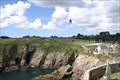
|  Fort de Bertheaume - Plougonvelin, Finistère, FRA Fort de Bertheaume - Plougonvelin, Finistère, FRA
in Zip-line Two ziplines crossing the narrow gorge between the coast and the islandfortress of Fort de Bertheaume. posted by:  André de Montbard André de Montbard location: Bretagne, France date approved: 11/29/2020 last visited: never |
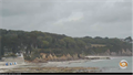 view gallery view galleryW4 km |  Webcam Vue sur la plage - Plougonvelin, France Webcam Vue sur la plage - Plougonvelin, France
in Web Cameras [EN] Webcam broadcasting live images, located on the roof of the tourist office of Plougonvelin.
[FR] Webcam diffusant des images en direct, située sur le toit de l'office de tourisme de Plougonvelin. posted by: pmaupin location: Bretagne, France date approved: 06/07/2017 last visited: never |
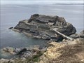 view gallery view gallerySE6.1 km |  L'îlot des Capucins - Roscanvel, France L'îlot des Capucins - Roscanvel, France
in Monuments Historiques Français L'îlot des Capucins, avancée rocheuse de la pointe des Capucins, est un îlot rocheux situé dans l'océan Atlantique au pied de la falaise de la commune de Roscanvel, dans la Presqu'île de Crozon en France. posted by: André de Montbard location: Bretagne, France date approved: 10/31/2020 last visited: 01/22/2023 |
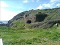
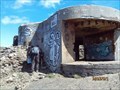
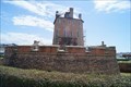
 view gallery view gallerySE6.1 km |  Fort de Capucins - Roscanvel, Camaret - Finistère, FRA Fort de Capucins - Roscanvel, Camaret - Finistère, FRA
in Historic Forts Îlot des Capucins (Islet of the Capuchins) is a rocky islet at the foot of a cliff in the commune of Roscanvel on the Crozon peninsula. posted by: André de Montbard location: Bretagne, France date approved: 10/30/2020 last visited: 01/22/2023 |
 view gallery view gallerySE7.4 km |  Fort de la Fraternité - Roscanvel, France Fort de la Fraternité - Roscanvel, France
in Castles FR - Le fort de la Fraternité se trouve sur la commune de Roscanvel. Il fait partie du système de défense du goulet de Brest.
EN - Fort de la Fraternité is located in the town of Roscanvel. It is part of the defense system of the Brest gully. posted by: geotrouvtou59 location: Bretagne, France date approved: 05/15/2023 last visited: 05/26/2023 |
 view gallery view gallerySE7.4 km |  Fort de la Fraternité - Roscanvel, France Fort de la Fraternité - Roscanvel, France
in Wikipedia Entries FR - Le fort de la Fraternité se trouve sur la commune de Roscanvel. Il fait partie du système de défense du goulet de Brest.
EN - Fort de la Fraternité is located in the town of Roscanvel. It is part of the defense system of the Brest gully. posted by: geotrouvtou59 location: Bretagne, France date approved: 05/09/2023 last visited: 05/10/2023 |
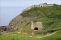 view gallery view gallerySE7.4 km | Fort de La Fraternité - Roscanvel, Camaret, 29, FRA in Historic Forts The Fort de la Fraternité (fort of brotherhood) is a fort located on the îlot du Diable in Roscanvel, France. posted by: André de Montbard location: Bretagne, France date approved: 10/31/2020 last visited: 01/22/2023 |
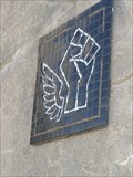 view gallery view gallerySE7.4 km |  Mosaic Main - Ilôt du Diable - Roscanvel, France Mosaic Main - Ilôt du Diable - Roscanvel, France
in Mosaics FR - Mosaique présent sur l'Îlot du Diable est une construction accessoire au fort de la Fraternité.
EN - Mosaic present on the Îlot du Diable is an accessory construction to Fort de la Fraternité. posted by: geotrouvtou59 location: Bretagne, France date approved: 05/09/2023 last visited: 05/10/2023 |
 view gallery view gallerySE7.4 km | Ilôt du Diable - Roscanvel, France in Wikipedia Entries FR - L'Îlot du Diable est une construction accessoire au fort de la Fraternité sur le système de défense du goulet de Brest.
EN - The Îlot du Diable is an accessory construction to the Fort de la Fraternité on the defense system of the Brest gully. posted by: geotrouvtou59 location: Bretagne, France date approved: 05/09/2023 last visited: 05/10/2023 |
 view gallery view gallery S7.9 km S7.9 km
| Phare du Toulinguet - Camaret-sur-Mer, Finistére, FRA in Coastal Lighthouses The Toulinguet lighthouse is located at the end of the Crozon peninsula in the town of Camaret-sur-Mer in Brittany. posted by: André de Montbard location: Bretagne, France date approved: 12/26/2020 last visited: 01/22/2023 |
 view gallery view gallery E8.7 km E8.7 km
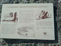
| Repère de nivellement, Roscanvel, Bretagne - France in French Benchmarks Repère situé sur un ancien fort à Roscanvel. / Marker located on an old fort in Roscanvel. posted by: GwenanDu location: Bretagne, France date approved: 04/01/2024 last visited: 07/12/2021 |
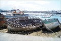 view gallery view gallerySE8.7 km |  Cimetière des bâteaux - Camaret-sur-Mer, Finistère, France Cimetière des bâteaux - Camaret-sur-Mer, Finistère, France
in Shipwrecks The wrecks of old fishing boats rotting at the Sillon de Camaret-sur-Mer. posted by: André de Montbard location: Bretagne, France date approved: 11/16/2020 last visited: 01/22/2023 |
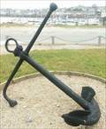 view gallery view gallerySE8.9 km |  Ancre de marine, Camaret sur Mer, Bretagne - France Ancre de marine, Camaret sur Mer, Bretagne - France
in Anchors Ancre de marine à Camaret sur Mer / Marine anchor in Camaret sur Mer posted by: GwenanDu location: Bretagne, France date approved: 04/08/2024 last visited: 04/08/2024 |
 view gallery view gallery N8.9 km N8.9 km
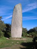
|  Le menhir de Kerloas Le menhir de Kerloas
in Megalithic Monuments Menhir de Kerloas, le plus haut en Bretagne / the greatest in Bretagne posted by: bob29 location: France date approved: 06/19/2007 last visited: 12/14/2014 |
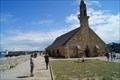 view gallery view gallerySE8.9 km | Chapelle de Notre-Dame-de-Rocamadour - Camaret-sur-Mer, France in Monuments Historiques Français Chapelle sur le Sillon de Camaret-sur-Mer, du nom de la vierge noire de Rocamadour.
-
Chapel at the Sillon of Camaret-sur-Mer, named after the black virgin of Rocamadour. posted by: André de Montbard location: Bretagne, France date approved: 11/16/2020 last visited: 01/22/2023 |
 view gallery view gallerySE8.9 km | Tour Vauban - Camaret-sur-Mer, France in Monuments Historiques Français La tour Vauban est une tour polygonale défensive construite de Vauban et érigée sur le Sillon à Camaret-sur-Mer.
-
The Vauban tower is a defensive polygonal tower built by Vauban and erected on the Sillon in Camaret-sur-Mer. posted by: André de Montbard location: Bretagne, France date approved: 11/16/2020 last visited: 01/22/2023 |
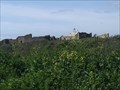
 view gallery view galleryS9 km | Alignements de Lagatjar - Camaret-sur-Mer, France in Wikipedia Entries FR - Les alignements de Lagatjar également dénommés alignements du Toulinguet.
EN - The alignments of Lagatjar also called alignments of Toulinguet. posted by: geotrouvtou59 location: Bretagne, France date approved: 05/10/2023 last visited: 05/12/2023 |
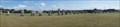 view gallery view galleryS9 km | Alignements de Lagatjar ou du Toulinguet, Camaret-sur-Mer, FRA in Megalithic Monuments The Alignements de Lagatjar are located in the town of Camaret-sur-Mer in Finistère.
-
Les Alignements de Lagatjar se trouvent sur la commune de Camaret-sur-Mer dans le Finistère. posted by: André de Montbard location: Bretagne, France date approved: 11/16/2020 last visited: 05/11/2023 |
 view gallery view galleryS9 km |  Alignements mégalithiques du Toulinguet- Camaret-sur-Mer, France Alignements mégalithiques du Toulinguet- Camaret-sur-Mer, France
in Satellite Imagery Oddities FR - Les alignements de Lagatjar également dénommés alignements du Toulinguet.
EN - The alignments of Lagatjar also called alignments of Toulinguet. posted by: geotrouvtou59 location: Bretagne, France date approved: 05/10/2023 last visited: 05/12/2023 |
 view gallery view galleryS9 km | Alignements de Lagatjar ou du Toulinguet, Camaret-sur-Mer, FRA in Monuments Historiques Français Les Alignements de Lagatjar se trouvent sur la commune de Camaret-sur-Mer dans le Finistère.
-
The Alignements de Lagatjar are located in the town of Camaret-sur-Mer in Finistère. posted by: André de Montbard location: Bretagne, France date approved: 11/16/2020 last visited: 05/11/2023 |
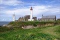 view gallery view galleryW9.2 km | Phare de Saint-Mathieu - Plougonvelin, Finistère, FRA in Coastal Lighthouses The Saint-Mathieu Lighthouse is a lighthouse located on Pointe Saint-Mathieu in Plougonvelin, around Brest in Finistère. The lighthouse is open to the public. posted by: André de Montbard location: Bretagne, France date approved: 11/18/2020 last visited: 12/11/2022 |
 view gallery view galleryS9.5 km |  Musée-mémorial de la bataille de l'Atlantique - Camaret-sur-Mer, FRA Musée-mémorial de la bataille de l'Atlantique - Camaret-sur-Mer, FRA
in War and Military Museums The Battle of the Atlantic Memorial located in Camaret-sur-Mer on the site of Fort Kerbonn, in a former blockhouse dating from the Second World War. posted by: André de Montbard location: Bretagne, France date approved: 01/09/2021 last visited: 01/22/2023 |
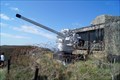 view gallery view galleryS9.5 km |  8,8 cm SK C/35 from U 766 - Point de Pen Hir, Finistére, FRA 8,8 cm SK C/35 from U 766 - Point de Pen Hir, Finistére, FRA
in Static Artillery Displays Main gun of U 766, a World War II german submarine, which surrendered 1945 at La Pallice in front of the Musée-mémorial de la bataille de l'Atlantique. posted by: André de Montbard location: Bretagne, France date approved: 12/26/2020 last visited: 01/22/2023 |
|