 view gallery view gallery NW5.3 km NW5.3 km
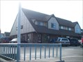
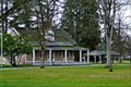
|   Fire House - Longbranch, WA Fire House - Longbranch, WA
in Blue Star Memorial Highway Markers This is near the Longbranch Fire Station on the Key Peninsula. posted by:  BethanyInWonderland BethanyInWonderland location: Washington date approved: 06/06/2010 last visited: 05/05/2012 |
 view gallery view gallery E7.4 km E7.4 km
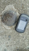
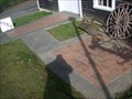
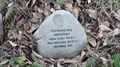
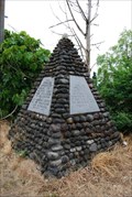
|  V 459 RM No 2 - Pierce County, WA V 459 RM No 2 - Pierce County, WA
in U.S. Benchmarks A Reference Mark for Benchmark V 459. posted by: yellow1961 location: Washington date approved: 08/28/2018 last visited: 08/29/2018 |
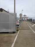 view gallery view galleryE7.9 km |  Steilacoom-Anderson Island Ferry - Steilacoom, WA Steilacoom-Anderson Island Ferry - Steilacoom, WA
in Ferries and Ferry Landings The Steilacoom-Anderson Island ferry is a ferry route in southern Puget Sound which is owned and operated by Pierce County, Washington. posted by:  alermy alermy location: Washington date approved: 02/10/2013 last visited: 12/30/2022 |
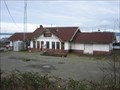 view gallery view galleryE8 km |  Steilacoom Depot - Steilacoom, Washington Steilacoom Depot - Steilacoom, Washington
in Train Stations/Depots Built in 1914 and located in a pretty village on the side of Puget Sound, this station last saw passengers in 1971. posted by: Bluejacket01 location: Washington date approved: 09/18/2013 last visited: 07/30/2014 |
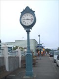 view gallery view galleryE8.2 km |  Peace and Freedom Clock - Steilacoom, WA Peace and Freedom Clock - Steilacoom, WA
in Town Clocks Freestanding Clock in Steilacoom, WA posted by: Prying Pandora location: Washington date approved: 09/07/2007 last visited: 07/30/2014 |
 view gallery view galleryE8.4 km |  Steilacoom, WA 98388 Steilacoom, WA 98388
in U.S. Post Offices Steilacoom, WA 98388 Post Office. posted by: The M & Ms location: Washington date approved: 02/19/2009 last visited: 07/30/2014 |
 view gallery view galleryE8.4 km |  Nathaniel H Orr Home Site - Steilacoom, WA Nathaniel H Orr Home Site - Steilacoom, WA
in Donated Engraved Bricks and Pavers Bricks donated to raise money for the Nathaniel H. Orr Home site. posted by: The M & Ms location: Washington date approved: 02/27/2009 last visited: 07/30/2014 |
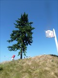
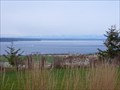
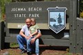 view gallery view galleryNW8.9 km |  Joemma Beach State Park, Washington State Joemma Beach State Park, Washington State
in State/Provincial Parks Joemma Beach State Park is a beautiful park with a pebble beach and pier. posted by: Woobie491 location: Washington date approved: 09/26/2012 last visited: 05/31/2009 |
 view gallery view galleryE9.2 km |  Chambers Creek Bridge - Steilacoom, WA Chambers Creek Bridge - Steilacoom, WA
in Railroad Bridges The BNSF Chambers Creek Lift Bridge, carries the BNSF mainline over Chambers Creek north of Steilacoom and beside Puget Sound in Washington state. posted by: HeyRob4449 location: Washington date approved: 11/12/2007 last visited: 08/14/2015 |
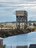 view gallery view galleryE9.7 km |  Chambers Creek Lift Bridge Chambers Creek Lift Bridge
in Vertical Lift Bridges The Chambers Creek Lift Bridge carries the BNSF & UP railroads across Chambers creek near Steilacoom, Washington. posted by: HeyRob4449 location: Washington date approved: 11/11/2007 last visited: 08/14/2015 |
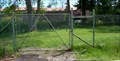
 view gallery view gallery NE9.8 km NE9.8 km
|  Footbridge Trail Improvement Footbridge Trail Improvement
in Eagle Scout Project Sites One of many Eagle Projects in Fox Island Nature Center. posted by: Prying Pandora location: Washington date approved: 03/04/2012 last visited: never |
 view gallery view galleryE10.1 km |  Chambers Bay Golf Course - University Place, Washington Chambers Bay Golf Course - University Place, Washington
in Public and Private Golf Courses Chambers Bay is a public golf course that, most famously, played host to the 2015 U.S. Open. posted by: Trail Blaisers location: Washington date approved: 09/05/2016 last visited: 08/21/2016 |
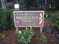 view gallery view galleryE10.3 km |  St. John Bosco Meditation Park - Lakewood, WA St. John Bosco Meditation Park - Lakewood, WA
in Outdoor Stations of the Cross This 1.3 acre meditation park attached to the grounds of St. John Bosco Catholic Church contains the Stations of the Cross as well as several shrines to Catholic saints. posted by: The Pirate King location: Washington date approved: 02/25/2024 last visited: 02/25/2024 |
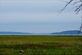 view gallery view gallery S10.3 km S10.3 km
|  Nisqually Delta - Olympia, Washington Nisqually Delta - Olympia, Washington
in U.S. National Natural Landmarks The Nisqually Delta is a temperate coastal salt marsh that is a major resting area for migratory waterfowl in the southern Puget Sound region. posted by: Hikenutty location: Washington date approved: 04/20/2007 last visited: 01/04/2017 |
 view gallery view galleryS10.3 km |  Nisqually Delta Overlook - Nisqually National Wildlife Refuge Nisqually Delta Overlook - Nisqually National Wildlife Refuge
in Scenic Overlooks This observation tower is located in a position to overlook the Nisqually delta, a National Natural Landmark. posted by: Hikenutty location: Washington date approved: 04/22/2007 last visited: 04/23/2007 |
 view gallery view galleryS10.3 km |  DESTINATION: Nisqually River - Puget Sound DESTINATION: Nisqually River - Puget Sound
in River Origins, Destinations and Confluences The Nisqually River originates at the Nisqually glacier on Mt. Rainier, and reaches the Puget Sound here, forming a lush estuary that is a National Natural Landmark and a National Wildlife Refuge. posted by: Hikenutty location: Washington date approved: 04/22/2007 last visited: 05/24/2008 |
 view gallery view galleryE10.5 km |  "A View to History" - Chambers Creek Area, University Place, WA "A View to History" - Chambers Creek Area, University Place, WA
in Washington Historical Markers This timeline of the Chambers Creek area lists events starting in 1830 and continuing to the present time. The three signs are located at the back of the Environmental Services Building which is near the Chambers Creek Playfields. posted by: Hikenutty location: Washington date approved: 03/09/2008 last visited: 12/07/2016 |
 view gallery view galleryE10.5 km |  Fort Steilacoom Cemetery Fort Steilacoom Cemetery
in Worldwide Cemeteries This is the cemetery for Fort Steilacoom, one of the first U.S. Army posts in the Northwest. posted by: adh73 location: Washington date approved: 06/01/2009 last visited: 07/30/2014 |
 view gallery view galleryE10.8 km | Fort Steilacoom Historical Marker in Washington Historical Markers Fort Steilacoom to Fort Walla Walla Military Road Marker posted by: RoGoBliss location: Washington date approved: 06/22/2008 last visited: 01/20/2021 |
 view gallery view galleryE10.8 km | Fort Steilacoom - Lakewood, Washington in Washington Historical Markers Fort Steilacoom was established as a military fort in 1849 by the US Government in response to the growing British presence in the area. In 1868 is was abandoned and the Washington Territory turned it into a mental asylum in 1871. posted by: Hikenutty location: Washington date approved: 02/26/2007 last visited: 07/30/2014 |
 view gallery view galleryE10.8 km |  Fort Steilacoom - Lakewood, Washington Fort Steilacoom - Lakewood, Washington
in U.S. National Register of Historic Places Fort Steilacoom was established as a military fort in 1849 by the US Government in response to the growing British presence in the area. In 1868 it was abandoned and the Washington Territory turned it into a mental asylum in 1871. posted by: Hikenutty location: Washington date approved: 02/26/2007 last visited: 07/30/2014 |
 view gallery view galleryE10.8 km |  "FORT STEILACOOM" - Lakewood, Washington "FORT STEILACOOM" - Lakewood, Washington
in Historic Forts Fort Steilacoom was established as a military fort in 1849 by the US Government in response to the growing British presence in the area. In 1868 is was abandoned and the Washington Territory turned it into a mental asylum in 1871. posted by: Hikenutty location: Washington date approved: 02/25/2007 last visited: 08/14/2015 |
 view gallery view galleryE10.8 km |  Western State Hospital/Fort Steilacoom - Steilacoom, WA Western State Hospital/Fort Steilacoom - Steilacoom, WA
in American Guide Series Western State Hospital still operates from this location, the site of Fort Steilacoom, built in 1849 and use for military purposes through 1868. The Washington Territory received the property and in 1871 turned it into a mental hospital. posted by: Hikenutty location: Washington date approved: 09/19/2007 last visited: 07/30/2014 |
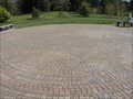 view gallery view galleryE10.8 km |  Chambers Creek Labyrinth Chambers Creek Labyrinth
in Labyrinths Located in Pierce County's 930-acre Chambers Creek Properties. posted by: GeoDiver location: Washington date approved: 04/06/2007 last visited: 07/30/2014 |
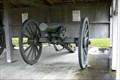 view gallery view galleryE10.9 km |  Fort Steilacoom Civil War Cannons - Lakewood, Washington Fort Steilacoom Civil War Cannons - Lakewood, Washington
in Static Artillery Displays Both of these cannons were used in the Civil War. One was forged by Revere Copper Company and the other by Henry N. Hooper & Co. in Boston, Massachusetts. They are located at the Historic Fort Steilacoom. posted by: Hikenutty location: Washington date approved: 02/25/2007 last visited: 07/30/2014 |
|