 view gallery view gallery N4.5 km N4.5 km
|   Schwarzsee - Blatten im Lötschental, VS, Switzerland Schwarzsee - Blatten im Lötschental, VS, Switzerland
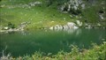
in Natural Lakes Schwarzsee on 1860 meters above sea level north of Blatten im Lötschental. posted by:  fi67 fi67 location: Valais, Switzerland date approved: 12/07/2019 last visited: never |
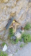
 view gallery view galleryN4.8 km |  Wooden Cross - Fafleralp, VS, Switzerland Wooden Cross - Fafleralp, VS, Switzerland
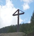
in Christian Crosses A wooden cross on a boulder north of Fafleralp. posted by: fi67 location: Valais, Switzerland date approved: 12/15/2019 last visited: never |
 view gallery view galleryN4.8 km |  Camping Gletscheralp - Fafleralp, VS, Switzerland Camping Gletscheralp - Fafleralp, VS, Switzerland
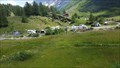
in Campgrounds A small campground near Fafleralp. posted by: fi67 location: Valais, Switzerland date approved: 12/17/2019 last visited: never |
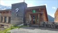
 view gallery view galleryN4.8 km |  Weston A. Price - Fafleralp, VS, Switzerland Weston A. Price - Fafleralp, VS, Switzerland
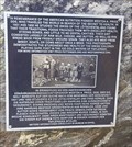
in Citizen Memorials A plaque on Fafleralp to commemorate a visit of the American nutrition pioneer Weston A. Price in the early 1930s. posted by: fi67 location: Valais, Switzerland date approved: 12/08/2019 last visited: never |
 view gallery view gallery NW5 km NW5 km
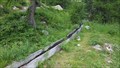
|  Hori-Suon Tellialp - Blatten im Lötschental, VS, Switzerland Hori-Suon Tellialp - Blatten im Lötschental, VS, Switzerland
in Ancient Aqueducts A traditional irrigation canal near Tellistaffel at the northern slope of Lötschental. posted by: fi67 location: Valais, Switzerland date approved: 12/17/2019 last visited: never |
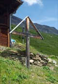 view gallery view galleryNW5.3 km | Wooden Cross Weritzalp - Blatten im Lötschental, VS, Switzerland in Christian Crosses A wooden cross next to a hiking trail in the Alpine hamlet Weritzalp. posted by: fi67 location: Valais, Switzerland date approved: 12/02/2019 last visited: never |
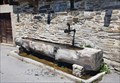
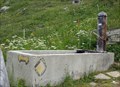 view gallery view galleryNW5.5 km |  Brunnen Weritzalp - Blatten im Lötschental, VS, Switzerland Brunnen Weritzalp - Blatten im Lötschental, VS, Switzerland
in Fountains A simple concrete fountain next to a hiking trail in the Alpine hamlet Weritzalp. posted by: fi67 location: Valais, Switzerland date approved: 12/01/2019 last visited: never |
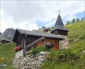 view gallery view galleryNW5.5 km |  Antonius-Kapelle Weritzalp - Blatten im Lötschental, VS, Switzerland Antonius-Kapelle Weritzalp - Blatten im Lötschental, VS, Switzerland
in Waychapels The small chapel on Weritzalp was built in 1976. posted by: fi67 location: Valais, Switzerland date approved: 12/02/2019 last visited: never |
 view gallery view gallery W5.6 km W5.6 km
|  Luftseilbahn Wiler-Lauchernalp - Wiler,VS, Switzerland Luftseilbahn Wiler-Lauchernalp - Wiler,VS, Switzerland
in Aerial Lifts An aerial tramway in the Lötschental region. posted by: fi67 location: Valais, Switzerland date approved: 10/27/2019 last visited: never |
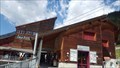
 view gallery view galleryW6.3 km |  Tourist Information Lötschental - Lauchernalp - Wiler,VS, Switzerland Tourist Information Lötschental - Lauchernalp - Wiler,VS, Switzerland
in Tourist Information Centers - Visitor Centers An information center of the Lötschental tourist information, next to the top station of the aerial tramway to Lauchernalp. posted by: fi67 location: Valais, Switzerland date approved: 10/31/2019 last visited: never |
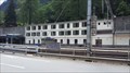 view gallery view galleryW7.7 km |  Goppenstein, VS, Switzerland Goppenstein, VS, Switzerland
in Train Stations/Depots The railway station at the southern end of the Lötschberg tunnel. posted by: fi67 location: Valais, Switzerland date approved: 12/22/2019 last visited: never |
 view gallery view gallery S8 km S8 km
|  Bietschtalbrücke - Raron, VS, Switzerland Bietschtalbrücke - Raron, VS, Switzerland
in Austrian and Swiss National Heritage Sites This steel bridge crosses the gorge of Bietschtal north of Raron. It was built from 1910 to 1913. posted by: fi67 location: Valais, Switzerland date approved: 08/03/2020 last visited: never |
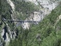 view gallery view galleryS8 km |  Bietschtalbrücke - Raron, VS, Switzerland Bietschtalbrücke - Raron, VS, Switzerland
in Railroad Bridges This steel bridge crosses the gorge of Bietschtal north of Raron. It was built from 1910 to 1913. posted by: fi67 location: Valais, Switzerland date approved: 08/03/2020 last visited: never |
 view gallery view galleryS8 km |  Bietschtalbrücke - Raron, VS, Switzerland Bietschtalbrücke - Raron, VS, Switzerland
in Truss Bridges This steel bridge crosses the gorge of Bietschtal north of Raron. It was built from 1910 to 1913. posted by: fi67 location: Valais, Switzerland date approved: 08/03/2020 last visited: never |
 view gallery view galleryS8 km |  Bietschtalbrücke - Raron, VS, Switzerland Bietschtalbrücke - Raron, VS, Switzerland
in Arch Bridges This steel bridge crosses the gorge of Bietschtal north of Raron. It was built from 1910 to 1913. posted by: fi67 location: Valais, Switzerland date approved: 08/04/2020 last visited: never |
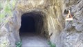 view gallery view galleryS8.2 km |  Construction Railway Tunnel Bietschtal - Raron, VS, Switzerland Construction Railway Tunnel Bietschtal - Raron, VS, Switzerland
in Abandoned Train Tunnels A former construction railway tunnel on the "Lötschberger Südrampe" hiking trail north of Raron. posted by: fi67 location: Valais, Switzerland date approved: 08/02/2020 last visited: never |
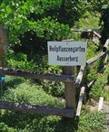 view gallery view galleryS8.4 km |  Heilpflanzengarten - Ausserberg, VS, Switzerland Heilpflanzengarten - Ausserberg, VS, Switzerland
in Demonstration Gardens Originally a private garden with medicinal herbs, now a well documented demonstration garden east of Ausserberg. posted by: fi67 location: Valais, Switzerland date approved: 10/30/2022 last visited: never |
 view gallery view galleryS8.4 km | Nogerbrunnen - Ausserberg, VS, Switzerland in Fountains A wooden fountain in the East of Ausserberg commemoration the 40th anniversary of a local yodeling club. posted by: fi67 location: Valais, Switzerland date approved: 10/06/2022 last visited: never |
 view gallery view galleryS8.5 km | Wooden Cross Bietschtal - Raron, VS, Switzerland in Christian Crosses A wooden cross commemorating the fatal accident of a six-years old girl in 1995. posted by: fi67 location: Valais, Switzerland date approved: 08/02/2020 last visited: never |
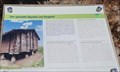 view gallery view galleryS8.5 km |  Der spezielle Spycher von Trogdorf - Ausserberg, VS, Switzerland Der spezielle Spycher von Trogdorf - Ausserberg, VS, Switzerland
in Signs of History One of the many traditional elevated barns of the Valais area, but this one has some uncommon features. posted by: fi67 location: Valais, Switzerland date approved: 10/05/2022 last visited: never |
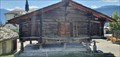 view gallery view galleryS8.5 km |  Der spezielle Spycher von Trogdorf - Ausserberg, VS, Switzerland Der spezielle Spycher von Trogdorf - Ausserberg, VS, Switzerland
in Elevated Buildings One of the many traditional elevated barns of the Valais area, but this one has some uncommon features. posted by: fi67 location: Valais, Switzerland date approved: 10/05/2022 last visited: never |
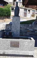 view gallery view galleryS8.5 km | Brunnen Heimattagung 1983 - Ausserberg, VS, Switzerland in Fountains A fountain in Ausserberg commemorating a social event in 1983. posted by: fi67 location: Valais, Switzerland date approved: 10/04/2022 last visited: never |
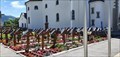 view gallery view galleryS8.5 km |  Churchyard Cemetery - Ausserberg, VS, Switzerland Churchyard Cemetery - Ausserberg, VS, Switzerland
in Churchyard Cemeteries The cemetery in the churchyard of Ausserberg. posted by: fi67 location: Valais, Switzerland date approved: 10/04/2022 last visited: never |
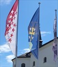 view gallery view galleryS8.5 km |  Municipal Flag - Ausserberg, VS, Switzerland Municipal Flag - Ausserberg, VS, Switzerland
in Municipal Flags The municipal flag of Ausserberg in front of the church. posted by: fi67 location: Valais, Switzerland date approved: 10/02/2022 last visited: never |
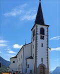 view gallery view galleryS8.5 km | Pfarrkirche St. Josef - Ausserberg, VS, Switzerland in Austrian and Swiss National Heritage Sites The Roman Catholic parish church of Ausserberg. posted by: fi67 location: Valais, Switzerland date approved: 10/04/2022 last visited: never |
|