![Image for T15S R8E S35 36 [T16S R8-1/2E S2] SC COR - Deschutes County, OR](https://img.geocaching.com/waymarking/small/1fc95c06-25b3-43da-90eb-2621e3cf9ab4.jpg) view gallery view gallery NE4.2 km NE4.2 km
|   T15S R8E S35 36 [T16S R8-1/2E S2] SC COR - Deschutes County, OR T15S R8E S35 36 [T16S R8-1/2E S2] SC COR - Deschutes County, OR
in Public Land Survey Marks PLSS standard corner set by USDA-Forest Service, William B. Ham in 2001; MONUMENT #4 on survey CS14797 filed in the Deschutes County Surveyors Office posted by:  Cooke17513 Cooke17513 location: Oregon date approved: 08/30/2015 last visited: never |
![Image for T15S R8E S36 [T16S R8-1/2E S1] SC 1/4 COR WC - Deschutes County, OR](https://img.geocaching.com/waymarking/small/e2c0d143-72d5-4ca7-a6c2-e322f7339cec.jpg) view gallery view gallery E5 km E5 km
| T15S R8E S36 [T16S R8-1/2E S1] SC 1/4 COR WC - Deschutes County, OR in Public Land Survey Marks PLSS witness corner set by USDA-Forest Service, William B. Ham in 2001; MONUMENT #3 on survey CS14797 filed in the Deschutes County Surveyors Office posted by: Cooke17513 location: Oregon date approved: 08/29/2015 last visited: never |
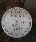
 view gallery view galleryNE5.3 km | TSW POL 9 - Deschutes County, OR in Public Land Survey Marks Point on Three Sisters Wilderness boundary line, monumented by Armstrong Surveying & Engineering Inc. under Deschutes National Forest Contract No. AG-04GG-C-08-0040, David B. Armstrong in 2008 posted by: Cooke17513 location: Oregon date approved: 08/30/2015 last visited: never |
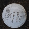 view gallery view galleryE5.3 km | 3 SISTERS WILDERNESS AREA POL 2 - Deschutes County, OR in Public Land Survey Marks Point on the Three Sisters Wilderness boundary set by USDA-Forest Service, William B. Ham in 2015 posted by: Cooke17513 location: Oregon date approved: 10/11/2015 last visited: never |
 view gallery view galleryE5.3 km | 3 SISTERS WILDERNESS AREA POL 3 - Deschutes County, OR in Public Land Survey Marks Point on the Three Sisters Wilderness boundary set by USDA-Forest Service, William B. Ham in 2015 posted by: Cooke17513 location: Oregon date approved: 11/15/2015 last visited: never |
 view gallery view galleryE5.5 km | 3 SISTERS WILDERNESS AREA POL 1 - Deschutes County, OR in Public Land Survey Marks Point on the Three Sisters Wilderness boundary set by USDA-Forest Service, William B. Ham in 2015 posted by: Cooke17513 location: Oregon date approved: 10/11/2015 last visited: never |
 view gallery view galleryE5.5 km |  AP 116 3 SISTERS WILDERNESS AREA AP 116 3 SISTERS WILDERNESS AREA
in U.S. Benchmarks Angle point located on the Three Sisters Wilderness boundary (Tract 3SWA) set by USDA-Forest Service, William B. Ham in 2015 posted by: Cooke17513 location: Oregon date approved: 11/15/2015 last visited: never |
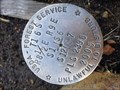
![Image for T15S R8E S36 R9E S31 [T16S R8-1/2E S1] SC COR - Deschutes County, OR](https://img.geocaching.com/waymarking/small/b6d12053-5146-41e5-809d-1350402a063c.jpg) view gallery view galleryE5.6 km | T15S R8E S36 R9E S31 [T16S R8-1/2E S1] SC COR - Deschutes County, OR in Public Land Survey Marks PLSS standard corner monumented by USDA-Forest Service, William B. Ham in 2001; MONUMENT #1 on survey CS14797 filed in the Deschutes County Surveyors Office posted by: Cooke17513 location: Oregon date approved: 08/29/2015 last visited: never |
 view gallery view galleryNE5.8 km | TSW POL 8 - Deschutes County, OR in Public Land Survey Marks Point on Three Sisters Wilderness boundary line, monumented by Armstrong Surveying & Engineering Inc. under Deschutes National Forest Contract No. AG-04GG-C-08-0040, David B. Armstrong in 2008. posted by: Cooke17513 location: Oregon date approved: 08/31/2015 last visited: never |
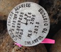
 view gallery view galleryE6.1 km | T16S R8-1/2E S12 13 R9E S7 18 COR - Deschutes County, OR in Public Land Survey Marks PLSS section corner set by USDA-Forest Service, William B. Ham in 2005; Oregon Corner Restoration Record, Index File No. 1744 posted by: Cooke17513 location: Oregon date approved: 10/11/2015 last visited: 11/07/2015 |
 view gallery view galleryE6.1 km | T16S R8-1/2E S1 12 R9E S6 7 COR - Deschutes County, OR in Public Land Survey Marks PLSS section corner set by USDA-Forest Service, William B. Ham in 2005; Oregon Corner Restoration Record, Index File No. 1741 posted by: Cooke17513 location: Oregon date approved: 10/30/2015 last visited: never |
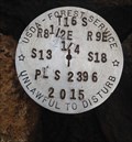 view gallery view galleryE6.3 km | T16S R8-1/2E S13 R9E S18 1/4 COR - Deschutes County, OR in Public Land Survey Marks PLSS quarter corner remonumented by USDA-Forest Service, William B. Ham in 2015 posted by: Cooke17513 location: Oregon date approved: 11/14/2015 last visited: never |
 view gallery view galleryNE6.3 km | TSW POL 7 - Deschutes County, OR in Public Land Survey Marks Point on Three Sisters Wilderness boundary line, monumented by Armstrong Surveying & Engineering Inc. under Deschutes National Forest Contract No. AG-04GG-C-08-0040, David B. Armstrong in 2008. posted by: Cooke17513 location: Oregon date approved: 08/31/2015 last visited: never |
 view gallery view gallery NW6.4 km NW6.4 km
| QD1000 - USDA FS 15, OR in U.S. Benchmarks USDA Forest Service Benchmark 15 posted by: Volcanoguy location: Oregon date approved: 09/23/2008 last visited: 09/23/2008 |
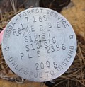
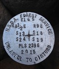 view gallery view galleryE6.4 km | T16S R8-1/2E S13 24 R9E S18 19 COR - Deschutes County, OR in Public Land Survey Marks PLSS section corner remonumented by USDA-Forest Service, William B. Ham in 2015 posted by: Cooke17513 location: Oregon date approved: 11/22/2015 last visited: never |
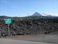
 view gallery view gallery N6.6 km N6.6 km
|  5325 Feet, McKenzie Pass Summit, OR 5325 Feet, McKenzie Pass Summit, OR
in Elevation Signs Elevation sign at McKenzie Pass on Ore Hwy 242. posted by: Volcanoguy location: Oregon date approved: 09/20/2008 last visited: 09/20/2008 |
 view gallery view galleryN6.6 km |  McKenzie Pass - Oregon McKenzie Pass - Oregon
in American Guide Series McKenzie Pass on Ore Hwy 242. posted by: Volcanoguy location: Oregon date approved: 09/22/2008 last visited: 09/22/2008 |
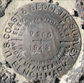 view gallery view galleryNW6.6 km | QD1001 - USCGS V360, OR in U.S. Benchmarks US Coast & Geodetic Survey benchmark V360 posted by: Volcanoguy location: Oregon date approved: 09/23/2008 last visited: 09/23/2008 |
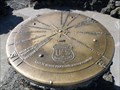 view gallery view galleryN6.6 km |  Dee Wright Observatory Orientation Table, Oregon Dee Wright Observatory Orientation Table, Oregon
in Orientation Tables This orientation table is on top of the Dee Wright Observatory. posted by: Volcanoguy location: Oregon date approved: 09/21/2008 last visited: 10/06/2022 |
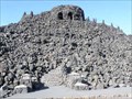 view gallery view galleryN6.6 km |  Dee Wright Observatory - McKenzie Pass, Oregon Dee Wright Observatory - McKenzie Pass, Oregon
in Civilian Conservation Corps This viewing structure built by the CCCs is located at McKenzie Pass. posted by: Volcanoguy location: Oregon date approved: 09/22/2008 last visited: 10/06/2022 |
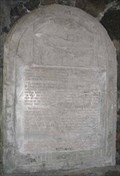 view gallery view galleryN6.6 km |  Dee Wright Observatory Dee Wright Observatory
in Oregon Historical Markers Stone plaque inside Dee Wright Observatory. posted by: Volcanoguy location: Oregon date approved: 10/10/2008 last visited: 10/06/2022 |
 view gallery view galleryN6.6 km |  Dee Wright Observatory - Oregon Hwy. 242 Dee Wright Observatory - Oregon Hwy. 242
in Scenic Roadside Look-Outs The Dee Wright Observatory at the summit of McKenzie Pass. posted by: Volcanoguy location: Oregon date approved: 09/27/2008 last visited: 10/06/2022 |
 view gallery view galleryN6.6 km | Dee Wright Observatory - Oregon in American Guide Series Dee Wright Observatory on Ore Hwy 242. posted by: Volcanoguy location: Oregon date approved: 09/22/2008 last visited: 10/06/2022 |
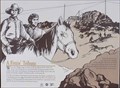 view gallery view galleryN6.6 km | A Fittin’ Tribute in Oregon Historical Markers A tribute to Dee Wright. One of four signs at Dee Wright Observatory. posted by: Volcanoguy location: Oregon date approved: 09/22/2008 last visited: 08/31/2012 |
 view gallery view galleryN6.6 km | Wisely Reasoned in Oregon Historical Markers Sign about CCC’s. One of four signs at Dee Wright Observatory. posted by: Volcanoguy location: Oregon date approved: 09/22/2008 last visited: 08/31/2012 |
|