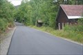
 view gallery view gallery S0.3 km S0.3 km
|   Tawhaus/Adirondac Tawhaus/Adirondac
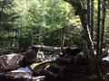
in Ghost Towns The remains of the village of Tawhaus (also known as Adirondac) which was formed to support the mining operations in the area now lies deserted. posted by:  Kenmore Kenmore location: New York date approved: 03/06/2013 last visited: 10/05/2017 |
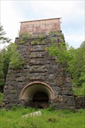 view gallery view galleryS1.3 km |  MacIntyre Iron Furnace MacIntyre Iron Furnace
in Iron Furnace Ruins An old steel blast furnace operated from 1827 to 1857 by the Adirondack Iron Works company. Powered by the upper reaches of the Hudson river, the furnace and other remnants sit beside the Upper Works road. posted by: Kenmore location: New York date approved: 06/19/2012 last visited: 10/05/2017 |
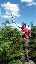
 view gallery view gallery W6.1 km W6.1 km
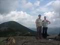
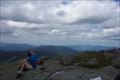
|  Santanoni Peak Summit Santanoni Peak Summit
in Mountain Summits Santanoni stands as the fourteenth highest peak in the Adirondacks, is the highest in the Santanoni Mountains. posted by: tatie location: New York date approved: 07/17/2011 last visited: 09/22/2007 |
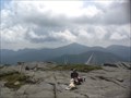
 view gallery view galleryW6.1 km | Panther Peak in Mountain Summits The eighteenth highest peak in the Adirondacks Panther is the second highest summit in the Santanoni Mountains and is the easiest to climb. posted by: tatie location: New York date approved: 07/25/2011 last visited: 09/22/2007 |
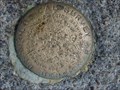
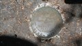 view gallery view galleryW6.1 km |  Panther Peak Panther Peak
in U.S. Benchmarks The eighteenth highest peak in the Adirondacks,Panther is the second highest summit in the Santanoni Mountains and is the easiest to climb. posted by: tatie location: New York date approved: 07/19/2011 last visited: 09/22/2007 |
 view gallery view gallery NE6.8 km NE6.8 km
| Iroquois Mountain - Adirondack High Peaks, NY in Mountain Summits This peak is listed as the 8th highest of the Adirondack high peaks. It is very close to Algonquin (2nd highest, as is Wright Peak) posted by: sagefemme location: New York date approved: 08/17/2014 last visited: 10/05/2017 |
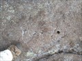
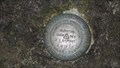
 view gallery view galleryNE8 km | USGS Bench Mark, (Unreadable), Mt Algoquin, NY in U.S. Benchmarks Top of mount Algonquin posted by:  gauglu gauglu location: New York date approved: 10/09/2007 last visited: 10/01/2016 |
 view gallery view galleryNE8 km | Algonquin Mountain - Adirondack High Peaks, NY in Mountain Summits Algonquin is the second highest of the Adirondack High Peaks behind Mt. Marcy at 5114 ft elev. posted by: sagefemme location: New York date approved: 08/17/2014 last visited: 10/08/2016 |
 view gallery view galleryW8.4 km | Couchsachraga in Mountain Summits If you want to become a ADK 46er, you will need to visit Couchsachraga. posted by: tatie location: New York date approved: 07/25/2011 last visited: 09/22/2007 |
 view gallery view galleryNE8.5 km | Mount Colden in Mountain Summits Mount Colden used to have a survdy marker at it's summit, but I was vandalized (stolen). The drill mounting has been augmented by a triangle anf the word "PEAK" etched into the stone. posted by: sagefemme location: New York date approved: 08/10/2017 last visited: never |
 view gallery view galleryNE8.9 km |  Wright Peak crash site - Adirondack State Park, NY Wright Peak crash site - Adirondack State Park, NY
in Plane Crash Sites A plaque was placed to commemorate the lives lost. Some wreckage remains today. posted by: sagefemme location: New York date approved: 08/12/2013 last visited: 07/29/2014 |
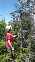
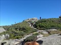
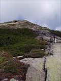
 view gallery view galleryNE9 km |  Trail marker to Wright Peak - Adirondack State Park Trail marker to Wright Peak - Adirondack State Park
in Cairns The is a whole string of cairns marking the trail along the bald top of Wright Peak. The one at these coordinates shows one of two especially well constructed one. Good thing for the cairns: the yellow paint blazes are fading. posted by: sagefemme location: New York date approved: 08/25/2013 last visited: never |
 view gallery view galleryNE9 km | Wright Peak - Adirondack State Park, NY in Mountain Summits Wright peak is 16th highest among the 46 High Peaks. It has a very small bald summit (as summits go) with an extensive Alpine Zone to traverse to reach it. The summit is 4580 feet above sea level, with a 2400 foot vertical ascent. posted by: sagefemme location: New York date approved: 08/13/2013 last visited: 10/08/2016 |
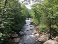
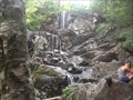 view gallery view galleryNE9.7 km |  MacIntyre Falls, Algonquin Peak trail, Adirondacks, NY MacIntyre Falls, Algonquin Peak trail, Adirondacks, NY
in Waterfalls Largest source of water on the trail to Algonquin Peak, and quite beautiful if you are willing to stop and rest a while here. posted by: sagefemme location: New York date approved: 08/11/2014 last visited: never |
 view gallery view galleryNE9.8 km | Indian Pass Trail in U.S. Benchmarks Benchmark found on Indian Pass Trail on my way to Mt. Marshall. posted by: tatie location: New York date approved: 07/12/2011 last visited: never |
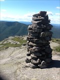
 view gallery view gallery E10.5 km E10.5 km
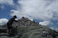
| Cairn, summit of Skylight mtn., New York, USA in Cairns Stone cairn on the summit of Skylight mountain posted by: Kenmore location: New York date approved: 01/28/2012 last visited: 06/19/2010 |
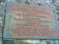
 view gallery view galleryNE10.6 km | AMD17 - 3415' elev marker - Lk Arnold Tr in U.S. Benchmarks Marker elevation reads 3415 ft above sea level.
Placed in 1942. posted by: sagefemme location: New York date approved: 08/10/2017 last visited: never |
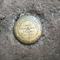
 view gallery view galleryE10.8 km | MARCY No 2 in U.S. Benchmarks Mount Marcy Summit posted by: sagefemme location: New York date approved: 07/22/2011 last visited: 03/19/2011 |
 view gallery view galleryE10.8 km | Mount Marcy - Adirondack State Park in Mountain Summits Mount Marcy is the highest of the 46 High Peaks in the Adirondacks.
As a day trip, it's 7.4 miles one way and 3166 foot ascent, (roughly 10 hr round trip) you will be rewarded with one of the best views ADK has to offer. posted by: sagefemme location: New York date approved: 11/28/2011 last visited: 07/12/2016 |
 view gallery view galleryE10.8 km |  The Adirondacks - New York, USA The Adirondacks - New York, USA
in 1000 Places to See Before You Die Adirondack Park covers over 6.1 million acres, which is more than Yellowstone, Yosemite, Grand Canyon, Glacier and Great Smoky Mountains National Parks combined. So what coordinates to use to waymark it? What other than the summit of Mount Marcy? posted by: sagefemme location: New York date approved: 02/12/2012 last visited: 11/25/2021 |
 view gallery view galleryE10.8 km |  Mount Marcy - highest point in New York State Mount Marcy - highest point in New York State
in Geographic High Points Mount Marcy is the highest of the 46 High Peaks in the Adirondacks at 5344 feet, and the highest point in New York State. posted by: sagefemme location: New York date approved: 02/03/2012 last visited: 09/04/2004 |
 view gallery view galleryNE11.3 km |  Marcy Dam - Adirondack State Park, NY Marcy Dam - Adirondack State Park, NY
in Water Dams Built in the 1930s by the Civilian Conservation Corps. posted by: sagefemme location: New York date approved: 07/19/2016 last visited: never |
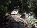
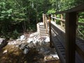 view gallery view galleryNE11.3 km |  Marcy Brook Water Bridge (replaces Marcy Dam) Marcy Brook Water Bridge (replaces Marcy Dam)
in Hiking Path Footbridges There are three wooden bridges along the VanHoevenberg Trail to Mount Marcy. THis us the first as you proceed from Heart Lake and Adirondack Lodge, and the newest, as it replaces the bridge crossing at Marcy Dam, which was destroyed by storms. posted by: sagefemme location: New York date approved: 07/13/2016 last visited: never |
 view gallery view galleryNE11.3 km | High Water Crossing, VanHoevenberg Trail in Hiking Path Footbridges There is a fording site over this Brook along the VanHoevenberg Trail just beyond Marcy Dam and well before Phelps Mountain trail junction, but when the water is high and running to fast to brave the fording site, this footbridge is a Godsend! posted by: sagefemme location: New York date approved: 07/13/2016 last visited: never |
 view gallery view galleryNE11.9 km | Vanhoevenberge Trail near Indian Falls in Hiking Path Footbridges This is the most remote of the VanHoevenberg footbridges. It is situated between the Phelps Mountain Trail junction (N 44 09.097 W 073 56.141) and Indian Falls junction of tabletop herdpath posted by: sagefemme location: New York date approved: 07/13/2016 last visited: never |
|