 view gallery view gallery SE2.3 km SE2.3 km
|   Union Grove Trail System - Beresford, SD Union Grove Trail System - Beresford, SD
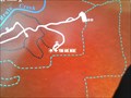
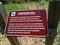
in 'You Are Here' Maps This is a trail head at a place in the park called Parkview Hill which is also the highest point in eastern South Dakota. posted by:  beta59 beta59 location: South Dakota date approved: 04/22/2012 last visited: 04/21/2012 |
 view gallery view gallerySE2.3 km |  HIGHEST - Point in Eastern South Dakota - Parkview Hill HIGHEST - Point in Eastern South Dakota - Parkview Hill
in Superlatives Parkview Hill in Union Grove State park south of Beresford, SD is the highest point in Eastern South Dakota. posted by: beta59 location: South Dakota date approved: 04/22/2012 last visited: never |
 view gallery view gallery E2.3 km E2.3 km
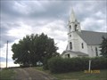
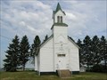
|  Roseni Lutheran Church - SD Roseni Lutheran Church - SD
in Country Churches Roseni Lutheran church Rural Beresford SD. posted by: MNSearchers location: South Dakota date approved: 06/24/2006 last visited: 12/27/2010 |
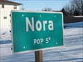 view gallery view galleryE6.3 km |  Nora, South Dakota, USA Nora, South Dakota, USA
in Population Signs Once a bustling community with two stores, a blacksmith and a creamery, Nora now boasts a population of 5. posted by:  wildernessmama wildernessmama location: South Dakota date approved: 02/11/2011 last visited: never |
 view gallery view gallery S9.7 km S9.7 km
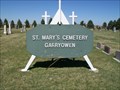
|  St. Mary Cemetery; Garryowen, South Dakota St. Mary Cemetery; Garryowen, South Dakota
in Worldwide Cemeteries Located near the former town of Garryowen, South Dakota. Elevation 1230.
300 graves posted by: NGComets location: South Dakota date approved: 04/20/2015 last visited: never |
 view gallery view gallery W9.8 km W9.8 km
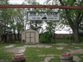
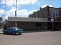
|  Hub City Hub City
in South Dakota Historical Markers On a midsummer's day on June 24, 1925 Wm. Inberg & Arvid Johnson opened the newly built gas station & repair business Hub City garage. posted by: GPX Navigators location: South Dakota date approved: 05/14/2006 last visited: 05/08/2010 |
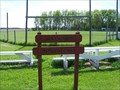 view gallery view galleryW10 km |  Ball Field, Hub City, South Dakota Ball Field, Hub City, South Dakota
in Amateur Baseball Fields Ben Carlson Memorial Field. Not so used anymore. posted by: NGComets location: South Dakota date approved: 05/12/2010 last visited: never |
 view gallery view gallery NW10.5 km NW10.5 km
| Dalesburg School - Dalesburg Village in South Dakota Historical Markers Name of Dalesburg, was suggested for this community of Swedish immigrants in 1869 when attempts were made to organize a church.
Dalesburg School was located one-half mile south of the village on land donated by the Bergs in 1872. posted by: GPX Navigators location: South Dakota date approved: 05/14/2006 last visited: 06/18/2006 |
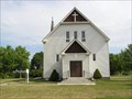
 view gallery view gallerySE10.8 km | Pleasant Hill Chapel - SD in Country Churches Pleasant Hill Chapel also known as United Brethren Church. posted by: MNSearchers location: South Dakota date approved: 07/14/2006 last visited: 07/14/2006 |
 view gallery view gallerySE10.8 km |  Pleasant Hill Chapel Pleasant Hill Chapel
in U.S. National Register of Historic Places Located in Union County SD. posted by: MNSearchers location: South Dakota date approved: 07/14/2006 last visited: 07/08/2006 |
 view gallery view galleryS12.4 km | Brule Creek Lutheran Church - SD in Country Churches Brule Creek Lutheran Church
31398 474th Ave.
Elk Point, SD posted by: MNSearchers location: South Dakota date approved: 07/18/2006 last visited: 07/08/2006 |
 view gallery view gallery N14.6 km N14.6 km
| St. John Catholic Cemetery, Beresford, South Dakota in Worldwide Cemeteries Medium sized cemetery southeast of the town. Elevation 1484 posted by: NGComets location: South Dakota date approved: 05/13/2019 last visited: never |
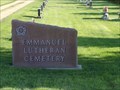 view gallery view galleryN14.6 km | Emmanuel Lutheran Cemetery, Beresford, South Dakota in Worldwide Cemeteries Small Lutheran cemetery tucked between two other cemeteries. Elecation 1476 posted by: NGComets location: South Dakota date approved: 05/13/2019 last visited: never |
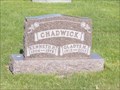 view gallery view galleryN14.8 km |  101 - Gladys M. Chadwick - Beresford, South Dakota 101 - Gladys M. Chadwick - Beresford, South Dakota
in Headstones of Centenarians Grave is located in the Emmanual Lutheran Cemetery, Beresford, SD.
Elevation 1489 posted by: NGComets location: South Dakota date approved: 05/13/2019 last visited: never |
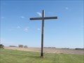 view gallery view galleryN14.8 km |  Cross, Beresford Memorial Park Cemetery, Beresford, South Dakota Cross, Beresford Memorial Park Cemetery, Beresford, South Dakota
in Churchyard Crosses Cross is the focal point in a newer cemetery. Elevation 1430 posted by: NGComets location: South Dakota date approved: 05/13/2019 last visited: never |
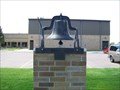 view gallery view galleryN15.3 km |  Bell, Beresford School, Beresford, South Dakota Bell, Beresford School, Beresford, South Dakota
in Bells Bell honoring the local schools in the area. posted by: NGComets location: South Dakota date approved: 05/11/2010 last visited: 07/01/2011 |
 view gallery view gallery NE15.6 km NE15.6 km
|  Alcester, South Dakota 57001 Alcester, South Dakota 57001
in U.S. Post Offices This small town had a population of 801 as of 2013. Its elevation is 1417 feet. posted by: NGComets location: South Dakota date approved: 03/31/2015 last visited: never |
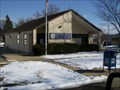
 view gallery view galleryN15.8 km | Beresford, South Dakota 57004 in U.S. Post Offices Small town post office. posted by: NGComets location: South Dakota date approved: 05/11/2010 last visited: 03/06/2011 |
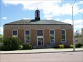
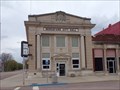 view gallery view galleryN15.8 km |  Security State Bank, Beresford, South Dakota, USA Security State Bank, Beresford, South Dakota, USA
in Converted Bank Buildings Currently the City Hall for Beresford, SD. Elevation 1485 posted by: NGComets location: South Dakota date approved: 05/20/2019 last visited: never |
 view gallery view galleryN15.9 km |  Evening Shadows the Land – Beresford, SD Evening Shadows the Land – Beresford, SD
in Murals Memories are priceless, and the recollections on this mural cast a light on the spirit of this small community. posted by: wildernessmama location: South Dakota date approved: 12/31/2010 last visited: 03/06/2011 |
 view gallery view galleryN15.9 km |  "American Legion Post 72" - Beresford, South Dakota "American Legion Post 72" - Beresford, South Dakota
in Legion Posts and Branches Named after the town, not any particular individual. posted by: NGComets location: South Dakota date approved: 05/25/2010 last visited: 03/06/2011 |
 view gallery view galleryNE15.9 km | Civilian Conservation Corps Camp - Alcester in South Dakota Historical Markers Camp SCS-3 (DPE-211 in 1934) located in city park of NE Alcester, companies: 2746 August 3 - October 1, 1934 and June 1935 to August 1941; 4725V August 1941 - May 1942. posted by: MNSearchers location: South Dakota date approved: 07/10/2006 last visited: 02/09/2011 |
 view gallery view galleryNE15.9 km | Archie M. Gubbrud in South Dakota Historical Markers Archie M. Gubbrud (December 31, 1910 – April 26, 1987) was the twenty-second Governor of South Dakota. posted by: MNSearchers location: South Dakota date approved: 07/10/2006 last visited: 12/27/2010 |
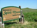 view gallery view gallery SW16.1 km SW16.1 km
|  SPIRIT MOUND A NATIONAL HISTORIC SITE Vermillion, South Dakota SPIRIT MOUND A NATIONAL HISTORIC SITE Vermillion, South Dakota
in Lewis and Clark Trail On August 25, 1804, Lewis and Clark walked to this conical hill which the Indians believed to be the residence of "little people or Spirits." posted by: RB2 location: South Dakota date approved: 06/27/2007 last visited: 07/30/2013 |
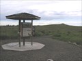 view gallery view gallerySW16.1 km | Spirit Mound in U.S. National Register of Historic Places Spirit Mound is located approximately six miles north of Vermillion, South Dakota on Hwy. 19. A state park, Spirit Mound Historic Prairie, was recently established, and the landscape is being restored. An interpretive sign is located at the I-29 Information Center near Junction City, and a small parking lot and day use area will be established by 2004 at the NW corner of the intersection of State Hwy. 19 and 312th St. For more information, visit the Spirit Mound Historic Prairie website or call posted by: MNSearchers location: South Dakota date approved: 06/27/2006 last visited: 07/30/2013 |
|