 view gallery view gallery SE6.9 km SE6.9 km
|   Brigden Water Tower Brigden Water Tower
in Water Towers A small town water tower. posted by:  Cargoman Cargoman location: Ontario, Canada date approved: 02/09/2009 last visited: never |
 view gallery view gallerySE7.4 km |  The Ploughman - Brigden, Ontario, Canada The Ploughman - Brigden, Ontario, Canada
in Roadside Attractions The Ploughman stands on guard at the original main gate of the Brigden Fair posted by: Tha Duh Feez location: Ontario, Canada date approved: 11/15/2012 last visited: never |
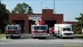 view gallery view gallery W9.2 km W9.2 km
|  R.C. Brock Fire Hall R.C. Brock Fire Hall
in Firehouses Corunna Fire Department posted by: Jay Walking location: Ontario, Canada date approved: 05/10/2007 last visited: 03/23/2012 |
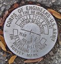 view gallery view gallery NW10.5 km NW10.5 km
|  US Army BM - Guthrie US Army BM - Guthrie
in Canadian Benchmarks A well preserved BM placed in 1981 by the US Army Corps of Engineers on the Canadian side of the St Clair River south of Sarnia, Ontario posted by:  Hard Oiler Hard Oiler location: Ontario, Canada date approved: 11/14/2005 last visited: 08/02/2009 |
 view gallery view galleryNW10.6 km | IBC Marker 48 in Canadian Benchmarks IBC Marker 48 is one of the land based International Boundary Commission markers used to define the US/Canada border along the St Clair River between Michigan and Ontario posted by: TnT location: Ontario, Canada date approved: 11/22/2005 last visited: 08/02/2009 |
 view gallery view galleryNW10.6 km |  The International Boundary The International Boundary
in Ontario Provincial Plaques This plaque recognizes the surveys carried out to define the boundary between Canada and the United States. posted by: Hard Oiler location: Ontario, Canada date approved: 03/08/2006 last visited: 05/17/2009 |
 NW10.6 km | IBC 48-42 in Canadian Benchmarks IBC Marker 48 (IBC19994842) is one of the land based International Boundary Commission markers used to define the US/Canada border along the St Clair River between Michigan and Ontario posted by: Hard Oiler location: Ontario, Canada date approved: 03/19/2006 last visited: 03/01/2019 |
 view gallery view galleryNW10.8 km | "FROOME AND FIELD TALFOURD" in Ontario Provincial Plaques This plaque marks the founding of Froomefield, one of the first settlements on the St. Clair river, by Froome and Field Talfourd in 1836. posted by: Hard Oiler location: Ontario, Canada date approved: 03/24/2006 last visited: 06/07/2020 |
 view gallery view galleryNW10.9 km |  Establishment of the Polymer Corporation Establishment of the Polymer Corporation
in Canadian National Historic Sites The establishment of the Polymer Corporation in 1942 to manufacture synthetic rubber allowed Canada to gain a significant foothold in the important field of polymer chemistry. posted by: Hard Oiler location: Ontario, Canada date approved: 04/06/2006 last visited: 05/17/2009 |
 view gallery view galleryW11.1 km | Sutherland’s Landing in Ontario Provincial Plaques This plaque marks the location of the first Anglican Church in the community of Sutherland’s Landing on the St Clair river. posted by: Hard Oiler location: Ontario, Canada date approved: 03/24/2006 last visited: never |
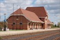 view gallery view gallery N11.3 km N11.3 km
|  Sarnia Train Station Sarnia Train Station
in Train Stations/Depots VIA Rail station in Sarnia, Ontario. Formerly of Canadian National Railway and Grand Trunk Railway. posted by: BWJM location: Ontario, Canada date approved: 04/25/2020 last visited: 04/19/2020 |
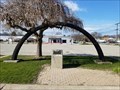
 view gallery view galleryN11.3 km |  Segment of St. Clair Tunnel, 1994 Segment of St. Clair Tunnel, 1994
in Freestanding Arches Segment of St. Clair Tunnel, 1994 posted by: BWJM location: Ontario, Canada date approved: 04/24/2020 last visited: 04/19/2020 |
 view gallery view galleryN11.3 km | Segment of St. Clair Tunnel, 1891 in Freestanding Arches Segment of St. Clair Tunnel, 1891 posted by: BWJM location: Ontario, Canada date approved: 04/24/2020 last visited: 04/19/2020 |
 view gallery view galleryW11.4 km |  City of Marysville Dog Park - Marysville,MI City of Marysville Dog Park - Marysville,MI
in Off-Leash Dog Areas Fenced in off-leash dog park in Marysville, Michigan. posted by: bobfrapples8 location: Michigan date approved: 07/05/2022 last visited: never |
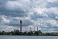 view gallery view galleryNW11.6 km |  Sarnia Regional Cogeneration Plant - Sarnia, Ontario Sarnia Regional Cogeneration Plant - Sarnia, Ontario
in Wikipedia Entries Natural gas cogeneration plant located across the St. Clair River from Port Huron in Sarnia, Ontario. posted by: bobfrapples8 location: Ontario, Canada date approved: 07/21/2022 last visited: 05/29/2024 |
 view gallery view galleryNW11.6 km |  Marysville Municipal Park - Marysville, MI Marysville Municipal Park - Marysville, MI
in Peace Poles Peace Pole located in Marysville Municipal Park in Marysville, Michigan. posted by: bobfrapples8 location: Michigan date approved: 08/29/2022 last visited: never |
 view gallery view galleryW11.6 km | 24U3256 - MMMCCLVI - IBC Marker 44 in Canadian Benchmarks IBC Marker 44 is one of the land based International Boundary Commission markers once used to define the US/Canada border along the St Clair River between Michigan and Ontario posted by: Hard Oiler location: Ontario, Canada date approved: 11/02/2005 last visited: 08/09/2009 |
 view gallery view galleryNW11.6 km | 693727: Topographical Survey Division Marker, Sarnia in Canadian Benchmarks A first order benchmark placed by the Topographical Survey Division of NRC in 1969 located on the North side of the CNR Tracks at the south end of Mitton ST. in Sarnia, Ontario.
posted by: Ardwell location: Ontario, Canada date approved: 08/02/2009 last visited: never |
 view gallery view galleryNW11.7 km | 693741: Topographical Survey Division Marker, Sarnia in Canadian Benchmarks A first order benchmark placed by the Topographical Survey Division of NRC in 1969 located south of Sarnia, Ontario opposite the Sunoco refinery. posted by: Hard Oiler location: Ontario, Canada date approved: 11/14/2005 last visited: 08/09/2009 |
 view gallery view galleryNW11.9 km |  C. H. Wills & Company C. H. Wills & Company
in Michigan Historical Markers Located on the south side of East Huron Boulevard, about 0.1 mile east of Busha Highway. Parking available at the Marysville Museum and park across East Huron Boulevard. posted by: S5280ft location: Michigan date approved: 10/23/2006 last visited: 07/06/2022 |
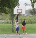 view gallery view galleryNW11.9 km |  Marysville City Park - Marysville, Michigan Marysville City Park - Marysville, Michigan
in Outdoor Basketball Courts Located east of Busha Highway on East Huron Boulevard. posted by: S5280ft location: Michigan date approved: 09/14/2007 last visited: 05/29/2024 |
 view gallery view galleryNW11.9 km |  Detroit Edison #203 - Marysville, MI Detroit Edison #203 - Marysville, MI
in Locomotives Built by Baldwin in 1923, this 0-6-0 steam engine shunted coal cars for Detroit Edison’s massive Marysville power plant for over 30 years. posted by: hykesj location: Michigan date approved: 06/14/2023 last visited: 05/29/2024 |
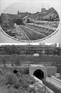 view gallery view galleryNW11.9 km |  St Clair River Tunnel St Clair River Tunnel
in Photos Then and Now The St. Clair River Tunnel was the first full-size submarine tunnel built in North America. Pictures show the Canadian portal in 1890 and 2006 posted by: Hard Oiler location: Ontario, Canada date approved: 06/03/2006 last visited: 04/19/2020 |
 view gallery view galleryNW11.9 km | Ontario’s Oil Refining Industry in Ontario Provincial Plaques This plaque recognizes the Oil Refining Industry in Ontario and is located at the Imperial Oil refinery which moved from Petrolia to Sarnia in 1899 starting what became the Chemical Valley – the major petrochemical centre in Ontario. posted by: Hard Oiler location: Ontario, Canada date approved: 03/17/2006 last visited: 09/12/2007 |
 view gallery view galleryNW11.9 km |  St Clair Tunnel St Clair Tunnel
in Abandoned Train Tunnels The first submarine rail tunnel connecting Sarnia, Ontario, Canada with Port Huron, Michigan.USA Completed in 1890, closed in 1994. posted by: Hard Oiler location: Ontario, Canada date approved: 04/21/2006 last visited: 04/19/2020 |
|