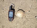
 view gallery view gallery N53.8 km N53.8 km
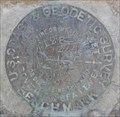
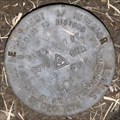
|   Cadastral Survey Marker LOI 51 Cadastral Survey Marker LOI 51
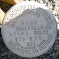
in U.S. Benchmarks Brass disk in Silver City, Idaho ghost town. posted by:  BadSquirrel BadSquirrel location: Idaho date approved: 03/19/2015 last visited: never |
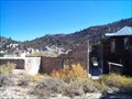 view gallery view galleryN53.8 km |  Silver City, Idaho Silver City, Idaho
in Ghost Towns Silver City was once Idaho's largest city. posted by:  cachegame cachegame location: Idaho date approved: 08/23/2006 last visited: 10/01/2020 |
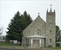 view gallery view gallery NW57 km NW57 km
|  Saint Bernard - Jordan Valley, OR Saint Bernard - Jordan Valley, OR
in Roman Catholic Churches A beautiful old stone church in rural Oregon. posted by: Phydux location: Oregon date approved: 05/11/2014 last visited: 05/19/2014 |
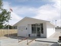
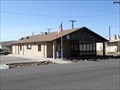 view gallery view galleryNW57.1 km |  Jordan Valley, OR. 97910 Jordan Valley, OR. 97910
in U.S. Post Offices The post office building in Jordan Valley, OR posted by: Volcanoguy location: Oregon date approved: 10/25/2009 last visited: 09/04/2014 |
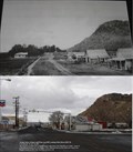 view gallery view galleryNW57.1 km |  Jordan Valley Oregon Jordan Valley Oregon
in Photos Then and Now Town of Jordan Valley OR posted by: St.Brendan location: Oregon date approved: 01/21/2006 last visited: 05/10/2014 |
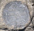
 view gallery view galleryNW57.1 km | NW0168 - USCGS J128 RESET, Oregon in U.S. Benchmarks U.S. Coast & Geodetic Survey benchmark J128 RESET posted by: Volcanoguy location: Oregon date approved: 03/01/2011 last visited: 05/10/2014 |
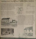 view gallery view galleryNW57.1 km |  Working Hard, Playing Hard - Jordan Valley Basque Working Hard, Playing Hard - Jordan Valley Basque
in Oregon Historical Markers This history sign is located near the corner of Bassett and Main Streets in Jordan Valley. posted by: Volcanoguy location: Oregon date approved: 02/28/2011 last visited: 05/10/2014 |
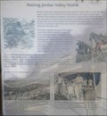 view gallery view galleryNW57.1 km | Making Jordan Valley Home in Oregon Historical Markers This history sign is located near the corner of Bassett and Main Streets in Jordan Valley. posted by: Volcanoguy location: Oregon date approved: 02/28/2011 last visited: 05/10/2014 |
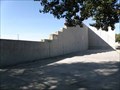 view gallery view galleryNW57.1 km |  Pelota Fronton - Jordan Valley, Oregon Pelota Fronton - Jordan Valley, Oregon
in U.S. National Register of Historic Places The historic Basques handball court in Jordan Valley, Oregon. posted by: Volcanoguy location: Oregon date approved: 02/26/2011 last visited: 05/10/2014 |
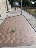 view gallery view galleryNW57.1 km |  Pelota Fronton Plaza - Jordan Valley, Oregon Pelota Fronton Plaza - Jordan Valley, Oregon
in Donated Engraved Bricks and Pavers Brick paver plaza at the historic Pelota Fronton in Jordan Valley, Oregon. posted by: Volcanoguy location: Oregon date approved: 02/26/2011 last visited: 05/10/2014 |
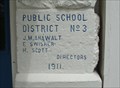 view gallery view galleryNW57.3 km |  1911 - Public School District No 3 - Jordan Valley, OR 1911 - Public School District No 3 - Jordan Valley, OR
in Dated Buildings and Cornerstones Jordan Valley Elementary School posted by: Phydux location: Oregon date approved: 05/12/2014 last visited: 05/19/2014 |
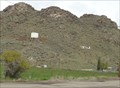 view gallery view galleryNW57.8 km |  JV - Jordan Valley, OR JV - Jordan Valley, OR
in Letters on Hills Letters for the high school in town. 42.978858, -117.057794 posted by: Phydux location: Oregon date approved: 05/11/2014 last visited: 05/19/2014 |
 view gallery view galleryNW63.7 km | 50th Anniversary of the Taylor Grazing Act in Oregon Historical Markers This history sign is located at the Vale Project Interpretive Site on U.S. Hwy. 95. posted by: Volcanoguy location: Oregon date approved: 02/28/2011 last visited: 05/10/2014 |
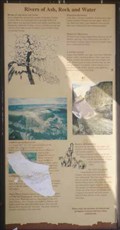 view gallery view galleryNW63.7 km | Rivers of Ash, Rock and Water in Oregon Historical Markers This history sign is located at the Vale Project Interpretive Site on U.S. Hwy. 95 about 12.5 miles southwest of Jordan Valley, Oregon. posted by: Volcanoguy location: Oregon date approved: 02/28/2011 last visited: 05/10/2014 |
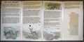 view gallery view galleryNW63.7 km | The Vale Project in Oregon Historical Markers This history sign is located at the Vale Project Interpretive Site on U.S. Hwy. 95 about 12.5 miles southwest of Jordan Valley, Oregon. posted by: Volcanoguy location: Oregon date approved: 02/28/2011 last visited: 05/10/2014 |
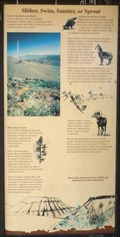 view gallery view galleryNW63.7 km |  Slither, Swim, Saunter, or Sprout - Owyhee Country, Oregon Slither, Swim, Saunter, or Sprout - Owyhee Country, Oregon
in Flora and Fauna Information Signs This Flora and Fauna sign is located at the Vale Project Interpretive Site on U.S. Hwy. 95 about 12.5 miles southwest of Jordan Valley, Oregon. posted by: Volcanoguy location: Oregon date approved: 03/01/2011 last visited: 05/10/2014 |
 view gallery view galleryNW63.7 km | USGS 81 FMK, Oregon in U.S. Benchmarks U.S. Geological Survey elevation mark 81 FMK posted by: Volcanoguy location: Oregon date approved: 02/27/2011 last visited: 10/01/2009 |
 view gallery view galleryNW63.7 km | NW0312 - USGS ZIP ET, Oregon in U.S. Benchmarks U.S. Geological Survey horizontal control point ZIP ET. posted by: Volcanoguy location: Oregon date approved: 02/27/2011 last visited: 10/01/2009 |
 view gallery view gallery NE66 km NE66 km
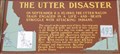
|  #493 - The Utter Disaster #493 - The Utter Disaster
in Idaho Historical Markers The Utter Disaster sign Idaho Hwy. 78. posted by: Volcanoguy location: Idaho date approved: 05/30/2011 last visited: 03/25/2016 |
 view gallery view galleryNE70.2 km | Grand View, Idaho 83624 in U.S. Post Offices The Grand View, Idaho Post Office. posted by: Volcanoguy location: Idaho date approved: 11/18/2010 last visited: 09/22/2010 |
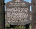 view gallery view galleryNW70.3 km | Charbonneau,Jean Baptiste, Memorial and Inskip Station Ruins in U.S. National Register of Historic Places There are three separate memorials for Jean Baptiste Charbonneau at this location. posted by: Queens Blessing location: Oregon date approved: 11/02/2008 last visited: 05/10/2014 |
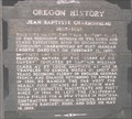 view gallery view galleryNW70.3 km | Jean Baptiste Charbonneau in Oregon Historical Markers Located 3 miles off US95 in the Southeastern area of Oregon. posted by: lazyCachers location: Oregon date approved: 06/04/2008 last visited: 05/10/2014 |
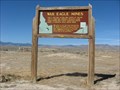 view gallery view galleryN71 km | War Eagle Mines, Idaho in Idaho Historical Markers For a decade after 1864 most of Silver City's mineral wealth came from Upper War Eagle Mountain which rises a verticle mile above here. posted by: Rose Red location: Idaho date approved: 12/25/2007 last visited: 03/25/2016 |
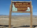 view gallery view galleryN71 km | Diamond Gulch, Idaho in Idaho Historical Markers According to the historical marker, in December 1865, Idaho's Governor--Caleb Lyon of Lyonsdale--set off a wild rush to Diamond Gulch, visible a few miles west of here with a tall tale. posted by: Rose Red location: Idaho date approved: 12/25/2007 last visited: 03/25/2016 |
 view gallery view galleryNW72.7 km | BLM 4408, Oregon in U.S. Benchmarks Bureau of Land Management Project Marker No. 4408 posted by: Volcanoguy location: Oregon date approved: 02/24/2011 last visited: 10/01/2009 |
|