 view gallery view gallery W12.6 km W12.6 km
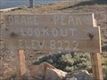
|   Drake Peak Lookout, 8222 feet elevation - Oregon Drake Peak Lookout, 8222 feet elevation - Oregon
in Elevation Signs Drake Peak. The fire lookout here, now retired, can be rented for an overnight fee from the Forest Service through the summer and fall months. posted by:  Flyin'SpiderFam Flyin'SpiderFam location: Oregon date approved: 07/26/2008 last visited: never |
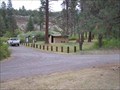
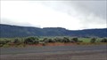
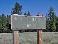 view gallery view galleryW15.8 km |  North Warner Viewpoint, Lake County, Oregon North Warner Viewpoint, Lake County, Oregon
in Scenic Overlooks A rustic viewpoint in the Fremont National Forest overlooking Warner Valley in Lake County, Oregon. posted by: Flyin'SpiderFam location: Oregon date approved: 07/26/2008 last visited: never |
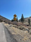 view gallery view gallery S16.1 km S16.1 km
|  Bighorn Sheep Bighorn Sheep
in Uncommon Crossing Signs In the middle of nowhere on Highway 140 there is a bighorn sheep crossing sign. posted by: funsigns location: Oregon date approved: 04/19/2021 last visited: never |
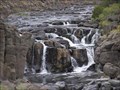 view gallery view galleryS18.2 km |  Deep Creek Falls, OR Deep Creek Falls, OR
in Waterfalls Deep Creek Falls along Hwy 140. posted by:  Volcanoguy Volcanoguy location: Oregon date approved: 10/18/2007 last visited: 07/03/2007 |
 view gallery view gallery SE19.3 km SE19.3 km
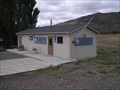
|  Adel, OR, 97620 Adel, OR, 97620
in U.S. Post Offices The Adel, OR Post Office. posted by: Volcanoguy location: Oregon date approved: 09/29/2007 last visited: 09/30/2007 |
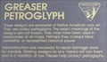 view gallery view gallerySE23.3 km |  Greaser Petroglyph, OR Greaser Petroglyph, OR
in Oregon Historical Markers Sign at the Greaser Petroglyph off Ore Hwy 140 near Greaser Canyon. posted by: Volcanoguy location: Oregon date approved: 10/29/2007 last visited: 10/29/2007 |
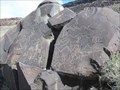 view gallery view gallerySE23.3 km |  Greaser Petroglyph Site Greaser Petroglyph Site
in U.S. National Register of Historic Places Petroglyphs north of Ore. Hwy. 140 near Greaser Canyon. posted by: Volcanoguy location: Oregon date approved: 11/13/2007 last visited: 11/13/2007 |
 view gallery view gallerySE23.3 km |  Greaser Petroglyph, OR Greaser Petroglyph, OR
in Pictographs Petroglyphs north of Ore. Hwy. 140 near Greaser Canyon. posted by: Volcanoguy location: Oregon date approved: 10/16/2007 last visited: 10/16/2007 |
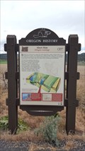
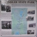 view gallery view galleryW24.6 km | Chandler State Park in Oregon Historical Markers History sign at Chandler State Park.
posted by: Volcanoguy location: Oregon date approved: 10/17/2007 last visited: 03/03/2013 |
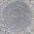
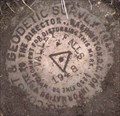
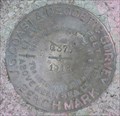 view gallery view galleryW24.8 km |  NY0105 - USCGS Q375, OR NY0105 - USCGS Q375, OR
in U.S. Benchmarks USCGS Benchmark Q375 posted by: Volcanoguy location: Oregon date approved: 10/19/2007 last visited: 03/03/2013 |
 view gallery view galleryW24.8 km |  Chandler State Wayside - Oregon Chandler State Wayside - Oregon
in State/Provincial Parks This wayside park is located along U.S. Hwy. 395 about 15 miles north of Lakeview, Oregon. posted by: Volcanoguy location: Oregon date approved: 10/26/2007 last visited: 03/03/2013 |
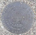
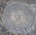 view gallery view galleryW25.1 km | NY0795 - USCGS DICK, OR in U.S. Benchmarks USCGS Triangulation Station DICK. posted by: Volcanoguy location: Oregon date approved: 10/19/2007 last visited: 10/20/2007 |
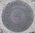 view gallery view galleryW25.1 km | NY0102 - USCGS P375, OR in U.S. Benchmarks USCGS Benchmark P375. posted by: Volcanoguy location: Oregon date approved: 10/20/2007 last visited: 10/20/2007 |
 view gallery view galleryW25.1 km | NY0795 - USCGS DICK NO 2, OR in U.S. Benchmarks USCGS Reference Mark DICK NO 2 posted by: Volcanoguy location: Oregon date approved: 10/19/2007 last visited: 10/20/2007 |
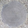 view gallery view galleryW25.1 km | NY0795 - USCGS DICK NO 1, OR in U.S. Benchmarks USCGS Reference Mark DICK NO 1. posted by: Volcanoguy location: Oregon date approved: 10/19/2007 last visited: 10/20/2007 |
 view gallery view gallery NW26.7 km NW26.7 km
|  Abert Rim - Oregon Geology - Lake County, OR Abert Rim - Oregon Geology - Lake County, OR
in Places of Geologic Significance A historical 'Beaver Board' located just of US 395 highlights the geological history of nearby Abert Rim. posted by: NW_history_buff location: Oregon date approved: 06/15/2017 last visited: never |
 view gallery view galleryNW26.7 km | Abert Rim (Hwy 31) in Oregon Historical Markers Oregon Geology Marker about Abert Rim on Ore. Hwy. 31. *UPDATE 6/4/17* This Beaver Board has been replaced and relocated to the west side of the highway and further south from the original. New coordinates updated. posted by: Volcanoguy location: Oregon date approved: 10/16/2007 last visited: 06/04/2017 |
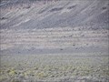 view gallery view gallerySE27.5 km | Lake Warner Shorelines, OR in Places of Geologic Significance Pluvial lake shorelines along Ore. Hwy. 140 east of Adel, Oregon. posted by: Volcanoguy location: Oregon date approved: 03/19/2008 last visited: 07/03/2007 |
 view gallery view galleryNW28.2 km | NY0793 - USCGS VALLEY FALLS, OR in U.S. Benchmarks USCGS Triangulation Station VALLEY FALLS. posted by: Volcanoguy location: Oregon date approved: 10/17/2007 last visited: 10/17/2007 |
 view gallery view galleryNW28.2 km | NY0793 - USCGS VALLEY FALLS NO 5, OR in U.S. Benchmarks USCGS Reference Mark VALLEY FALLS NO 5. posted by: Volcanoguy location: Oregon date approved: 10/17/2007 last visited: 10/17/2007 |
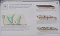 view gallery view galleryNW29.3 km | A fractured piece of the Earth’s crust in Oregon Historical Markers One of three signs about the Abert Rim and Abert Lake area on U.S. Hwy. 395. posted by: Volcanoguy location: Oregon date approved: 10/16/2007 last visited: 08/16/2019 |
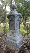 view gallery view gallery SW31.4 km SW31.4 km
|  Thomas B. Alford & Rosa Irene Mulkey - IOOF Cemetery - Lakeview, OR Thomas B. Alford & Rosa Irene Mulkey - IOOF Cemetery - Lakeview, OR
in Zinc Headstones One of a number of zinc headstones located in historic IOOF Cemetery. posted by: NW_history_buff location: Oregon date approved: 10/22/2019 last visited: never |
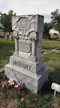 view gallery view gallerySW31.4 km |  Clara E. Rehart - IOOF Cemetery - Lakeview, OR Clara E. Rehart - IOOF Cemetery - Lakeview, OR
in Woodmen of the World Grave Markers/Monuments One of a few WoW headstones located in historic IOOF Cemetery. posted by: NW_history_buff location: Oregon date approved: 10/21/2019 last visited: never |
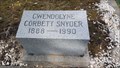 view gallery view gallerySW31.4 km |  101 - Gwendolyne Corbett Snyder - Lakeview, OR 101 - Gwendolyne Corbett Snyder - Lakeview, OR
in Headstones of Centenarians One of a few centenarians located in historic IOOF Cemetery. posted by: NW_history_buff location: Oregon date approved: 10/22/2019 last visited: never |
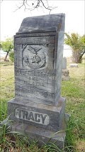 view gallery view gallerySW31.4 km | Walter D. Tracy - IOOF Cemetery - Lakeview, OR in Woodmen of the World Grave Markers/Monuments One of a few Wow headstones located in historic IOOF Cemetery. posted by: NW_history_buff location: Oregon date approved: 10/21/2019 last visited: never |
|