 view gallery view gallery W6.1 km W6.1 km
|   Saint John the Baptist Catholic Cemetery - Ammannsville, TX Saint John the Baptist Catholic Cemetery - Ammannsville, TX
in Worldwide Cemeteries Also known as Ammannsville Catholic Cemetery. Located across the parking lot from the church. posted by:  WalksfarTX WalksfarTX location: Texas date approved: 06/19/2017 last visited: never |
 view gallery view galleryW6.1 km |  St. John the Baptist Catholic Church - Ammannsville, TX St. John the Baptist Catholic Church - Ammannsville, TX
in This Old Church It was built in 1917 and added to the National Register of Historic Places in 1983. posted by: WalksfarTX location: Texas date approved: 06/19/2017 last visited: 05/08/2021 |
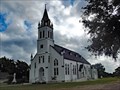 view gallery view galleryW6.1 km | St. John the Baptist Catholic Church - Ammannsville, TX in Roman Catholic Churches St. John the Baptist Catholic church opened in 1890. Destroyed by the hurricane of 1909, the church was rebuilt. It burned and had to be rebuilt a second time. posted by: WalksfarTX location: Texas date approved: 06/19/2017 last visited: 05/08/2021 |
 view gallery view galleryW6.1 km |  St. John the Baptist Catholic Church - Ammannsville, TX St. John the Baptist Catholic Church - Ammannsville, TX
in U.S. National Register of Historic Places It was built in 1917 and added to the National Register of Historic Places in 1983. posted by: WalksfarTX location: Texas date approved: 06/19/2017 last visited: 05/08/2021 |
 view gallery view gallery SW8.2 km SW8.2 km
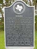
|  Dubina Dubina
in Texas Historical Markers A Texas historical marker on FM 1383 is found just north of the junction of Piano Bridge Road, close to the Sts Cyril and Methodius Catholic Church in Dubina, TX. posted by:  WayBetterFinder WayBetterFinder location: Texas date approved: 03/10/2020 last visited: 03/10/2020 |
 view gallery view gallerySW8.4 km | Saints Cyril and Methodius Church - Dubina, TX in This Old Church Dubina was a Czech settlement began in 1856. Dubina's first church was built in 1876, but was destroyed by a 1909 hurricane. Rebuilt in 1911, it survived a fire that all but destroyed the town. posted by: WalksfarTX location: Texas date approved: 06/19/2017 last visited: 04/07/2021 |
 view gallery view gallerySW8.4 km |  Saints Cyril and Methodius Church - Dubina Historic District - Dubina, TX Saints Cyril and Methodius Church - Dubina Historic District - Dubina, TX
in NRHP Historic Districts - Contributing Buildings Dubina was a Czech settlement began in 1856. Dubina's first church was built in 1876, but was destroyed by a 1909 hurricane. Rebuilt in 1911, it survived a fire that all but destroyed the town. posted by: WalksfarTX location: Texas date approved: 06/19/2017 last visited: 04/07/2021 |
 view gallery view gallerySW8.4 km | Saints Cyril and Methodius Church - Dubina, TX in Roman Catholic Churches Dubina was a Czech settlement began in 1856. Dubina's first church was built in 1876, but was destroyed by a 1909 hurricane. Rebuilt in 1911, it survived a fire that all but destroyed the town. posted by: WalksfarTX location: Texas date approved: 06/19/2017 last visited: 04/07/2021 |
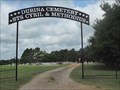 view gallery view gallerySW8.4 km | Sts. Cyril and Methodius Catholic Cemetery - Dubina, Texas in Worldwide Cemeteries The Sts. Cyril and Methodius Cemetery, which is owned by the church, has served the Dubina Community since shortly after its founding in 1856 and continues in use today. posted by: WalksfarTX location: Texas date approved: 06/19/2017 last visited: never |
 view gallery view gallery NE9.2 km NE9.2 km
| James J. Ross in Texas Historical Markers Roadside marker detailing the history of one of the first settlers of Texas. posted by: rilekyle location: Texas date approved: 12/28/2006 last visited: 06/25/2009 |
 view gallery view gallery SE10 km SE10 km
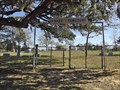
| Old Osage in Texas Historical Markers Metal marker on a metal pole in front of a large mowed field with picnic tables. posted by: WalksfarTX location: Texas date approved: 11/26/2017 last visited: never |
 view gallery view gallerySE10 km | Osage Cemetery - Colorado County, TX in Worldwide Cemeteries The Osage Community Cemetery served and continues to serve the Osage community today. The earliest known burial is 1860. posted by: WalksfarTX location: Texas date approved: 11/25/2017 last visited: never |
 view gallery view gallery S10.5 km S10.5 km
| Weimar Masonic Cemetery - Weimar, TX in Worldwide Cemeteries Adjacent to and indistinguishable from the Weimar Odd Fellows Cemetery. Also next to Paradise Gardens Cemetery but a fence separates them for easier identification. posted by: WalksfarTX location: Texas date approved: 11/25/2017 last visited: never |
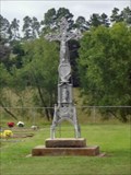
 view gallery view galleryS10.6 km |  Allen Family Memorial - Weimer, TX Allen Family Memorial - Weimer, TX
in Woodmen of the World Grave Markers/Monuments Tall white marker with four columns supporting an urn draped in a cloth. Inside the four columns is a vase for flowers. posted by: WalksfarTX location: Texas date approved: 11/25/2017 last visited: never |
 view gallery view galleryS10.6 km | John Pettit Borden in Texas Historical Markers Metal Grave Marker on short post near the obelisk marker. posted by: WalksfarTX location: Texas date approved: 11/26/2017 last visited: never |
 view gallery view gallery NW12.1 km NW12.1 km
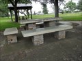
|  Roadside Park – La Grange TX Roadside Park – La Grange TX
in WPA Projects This roadside park, constructed adjacent to U.S. Hwy 77, was part of the development of roadside parks begun in 1935 in anticipation of tourists and visitors to Texas for the 1936 Texas Centennial celebration. posted by: WalksfarTX location: Texas date approved: 06/21/2017 last visited: never |
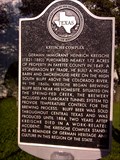
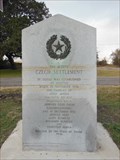 view gallery view galleryNW12.1 km | The Oldest Czech Settlement in Texas Historical Markers This old gray granite historical marker is along the roadside of TX Hwy 77 where it intersects with Farm to Market Road 2436, about 4-5 miles south of La Grange, TX. posted by: WayBetterFinder location: Texas date approved: 12/20/2012 last visited: 03/15/2017 |
 view gallery view galleryNW12.1 km |  AX0925 B 843 -- Hostyn TX AX0925 B 843 -- Hostyn TX
in U.S. Benchmarks A benchmark on the base of the Augustine Hadusek monument posted by: Benchmark Blasterz location: Texas date approved: 05/09/2017 last visited: 03/15/2017 |
 view gallery view galleryNW12.1 km |  Augustine Haidusek - La Grange, TX Augustine Haidusek - La Grange, TX
in Citizen Memorials This pink granite civilian memorial to Augusine Haidusek is along the roadside of TX Hwy 77 where it intersects with Farm to Market Road 2436, about 4-5 miles south of La Grange, TX. posted by: WayBetterFinder location: Texas date approved: 12/12/2012 last visited: 03/15/2017 |
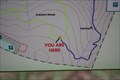 view gallery view galleryNW12.7 km |  YOU ARE HERE -- Trail Sign Monument Hill/Kreische Brewery State Historic Sites (La Grange, Texas) YOU ARE HERE -- Trail Sign Monument Hill/Kreische Brewery State Historic Sites (La Grange, Texas)
in 'You Are Here' Maps It's easy to wonder where you are, once your trail winds into the trees. This handy trailside map sorts you out. Nope, you're not lost -- just meandering. posted by: Tygress location: Texas date approved: 09/28/2010 last visited: 03/18/2016 |
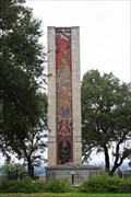
 view gallery view galleryNW12.7 km |  Monument Hill & Kreische Brewery State Historic Sites - La Grange, TX Monument Hill & Kreische Brewery State Historic Sites - La Grange, TX
in State/Provincial Parks Monument Hill and Kreische Brewery State Historic Site, 40.4 acres total, is located one mile south of La Grange in Fayette County. posted by: WalksfarTX location: Texas date approved: 05/09/2018 last visited: never |
 view gallery view galleryNW12.7 km |  Monument Hill and Kreische Brewery State Historic Sites Monument Hill and Kreische Brewery State Historic Sites
in Wikipedia Entries Hallowed ground & historic site--this Texas Park serves a dual purpose of preserving the tomb and monument to the victims of the 1842-43 "Dawson Massacre" & Mier "Black Bean Lottery" and Henry Kreische's historic home and brewery. Great views, too! posted by: Tygress location: Texas date approved: 09/28/2010 last visited: 04/10/2016 |
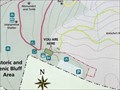 view gallery view galleryNW12.7 km | Monument Hill and Kreische Brewery State Historic Site - LaGrange, TX in 'You Are Here' Maps Map of the trails in the historic site is located at the edge of the parking lot. posted by: WalksfarTX location: Texas date approved: 05/09/2018 last visited: never |
 view gallery view galleryNW12.7 km | Monument Hill Tomb in Texas Historical Markers Found this one outside LaGrange in Fayette County. posted by: jackrock location: Texas date approved: 01/07/2010 last visited: 11/22/2017 |
 view gallery view galleryNW12.7 km | Kreische Complex in Texas Historical Markers Located outside LaGrange in Fayette County. posted by: jackrock location: Texas date approved: 01/07/2010 last visited: 11/22/2017 |
|