 view gallery view gallery SE1.1 km SE1.1 km
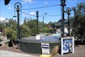
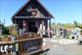
|   The Hanmer Springs Gasometer, The Hanmer Springs Gasometer,
in Gasometers This gasometer was commisioned in 1898 and supplied gas to the sanitorium. It was decommisioned in 1940 when the town was connected to the national grid. posted by:  greysman greysman location: South Island, New Zealand date approved: 03/27/2011 last visited: 03/07/2013 |
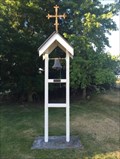 view gallery view gallerySE48.9 km |  St Anthonys Catholic Church - Cheviot, New Zealand St Anthonys Catholic Church - Cheviot, New Zealand
in Bell Towers The picturesque St Anthony's Catholic Church, located on a scenic just on the edge of Cheviot township posted by: waiiti20 location: South Island, New Zealand date approved: 02/19/2016 last visited: 02/19/2016 |
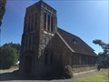 view gallery view gallerySE49.9 km |  Knox Presbyterian Church - Cheviot, New Zealand Knox Presbyterian Church - Cheviot, New Zealand
in Cobblestone Buildings This stone church is built with stones gathered from near the Hurunui River. It was opened in September 1953. posted by: waiiti20 location: South Island, New Zealand date approved: 02/22/2016 last visited: 02/21/2016 |
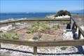
 view gallery view gallerySE50.4 km |  Cheviot Hills Reserve - Cheviot, Canterbury, New Zealand Cheviot Hills Reserve - Cheviot, Canterbury, New Zealand
in Municipal Parks and Plazas Cheviot Hills Reserve is managed by Hurunui District Council and is a fine place to walk and geocache (and now waymark!). There are some very large trees. Sheep graze throughout the woodlands. posted by: Trail Blaisers location: South Island, New Zealand date approved: 01/02/2014 last visited: never |
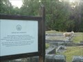 view gallery view gallerySE50.9 km |  Cheviot Hills Homestead - Cheviot, Canterbury, New Zealand Cheviot Hills Homestead - Cheviot, Canterbury, New Zealand
in Preserved Architectural Remnants and Ruins Cheviot Hills Homestead (locally known as Mansion House) burnt down in 1936, leaving only the sandstone foundation that you can see today. posted by: Trail Blaisers location: South Island, New Zealand date approved: 01/18/2014 last visited: never |
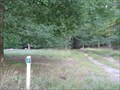
  N60.4 km N60.4 km
|  John Tait Hut - Travers Valley _ Nelson Lakes National Park John Tait Hut - Travers Valley _ Nelson Lakes National Park
in Remote Backcountry Shelters A serviced DoC Hut in the Travers Valley posted by: madiecacher location: South Island, New Zealand date approved: 07/28/2008 last visited: never |
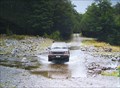 view gallery view galleryN68.1 km |  Six Mile Creek. Rainbow Valley. South Is. New Zealand. Six Mile Creek. Rainbow Valley. South Is. New Zealand.
in Bridgeless Water Crossings Six Mile Creek crosses the wilderness Rainbow Road linking St Arnaud and Hanmer Springs. There is a rough ford where the road crosses the stream just past the Rainbow Ski Area turn-off, 26 km from the Wairau Valley road end. posted by: Punga and Paua location: South Island, New Zealand date approved: 04/30/2009 last visited: 09/05/2009 |
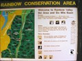 view gallery view galleryN68.2 km |  You Are Here at Rainbow Conservation Area. South Is. New Zealand. You Are Here at Rainbow Conservation Area. South Is. New Zealand.
in 'You Are Here' Maps "You Are Here" at the base of the Rainbow Ski Field Road in the Six Mile Basin at Rainbow Conservation Area. posted by: Punga and Paua location: South Island, New Zealand date approved: 04/30/2009 last visited: 04/30/2009 |
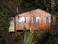 view gallery view galleryN69.4 km | D'urville Hut in Remote Backcountry Shelters Sited at the head of Lake Rotoroa in the Nelson Lakes Park posted by:  StagsRoar StagsRoar location: South Island, New Zealand date approved: 12/28/2005 last visited: never |
 view gallery view galleryN71.3 km | Lake Head Hut - Travers Valley in Remote Backcountry Shelters Located at the head of Lake Rotoiti at the outlet of the Travers River posted by: StagsRoar location: South Island, New Zealand date approved: 12/27/2005 last visited: never |
 view gallery view gallery E71.8 km E71.8 km
| South Bay Whaling Station, Kaikoura, New Zealand. in Preserved Architectural Remnants and Ruins The last visible remnants of the Whaling Industry in Kaikoura's South Bay are preserved in this enclosure. posted by: greysman location: New Zealand date approved: 03/24/2011 last visited: 04/05/2013 |
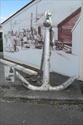 view gallery view galleryE71.9 km |  Mooring Anchor, Kaikoura Museum, Kaikoura, New Zealand. Mooring Anchor, Kaikoura Museum, Kaikoura, New Zealand.
in Anchors A mooring anchor recovered from the area of New Wharf to the south of Kaikoura city in 1964. Probably laid in about 1910 to anchor mooring buoys to which ships could secure their bow or stern lines. posted by: greysman location: South Island, New Zealand date approved: 03/23/2011 last visited: never |
 view gallery view galleryE71.9 km | Mooring Anchor, Barnacle Bills, Scarborough Street, Kaikoura, New Zealand. in Anchors Two mooring anchors probably recovered from the sea off Kaikoura's New Quay. posted by: greysman location: South Island, New Zealand date approved: 03/25/2011 last visited: never |
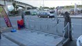
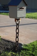 view gallery view galleryE72.1 km |  South Bay Anti-grav Box, Kaikoura, NZ South Bay Anti-grav Box, Kaikoura, NZ
in Themed Homemade Mailboxes This home made letter box defies gravity, maybe it was made in England? posted by: greysman location: South Island, New Zealand date approved: 03/26/2011 last visited: never |
 view gallery view galleryE72.1 km |  Kaikoura Mini Golf, Beach Road, Kaikoura, New Zealand. Kaikoura Mini Golf, Beach Road, Kaikoura, New Zealand.
in Miniature Golf An eight hole crazy mini golf course set around DidjeriDoo (used to be the Candy Shack) on Beach Road, heading north out of Kaikoura on SH1. posted by: greysman location: South Island, New Zealand date approved: 03/24/2011 last visited: 02/13/2016 |
 view gallery view galleryE72.1 km |  Underwater cutout, DidjeriDoo, Beach Road, Kaikoura, New Zealand. Underwater cutout, DidjeriDoo, Beach Road, Kaikoura, New Zealand.
in Photo Cutouts A board with an underwater scene and three cutouts placed outside 'DidjeriDoo' which also features a crazy mini golf course. posted by: greysman location: South Island, New Zealand date approved: 03/23/2011 last visited: never |
 view gallery view galleryE72.1 km |  "Whale" tender - Kaikoura - New Zeeland "Whale" tender - Kaikoura - New Zeeland
in Bicycle Tenders Bicycle tender in the "Whale" town Kaikoura. posted by: superstein location: South Island, New Zealand date approved: 05/23/2020 last visited: never |
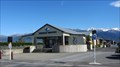 view gallery view galleryE72.3 km |  Kaikoura - New Zealand Kaikoura - New Zealand
in Train Stations/Depots Kaikoura (Nieuw-Zeeland) Station: The railway station of Kaikoura (New Zealand). Stop of the "Coastal Pacific" train. posted by: superstein location: South Island, New Zealand date approved: 09/01/2015 last visited: 03/23/2024 |
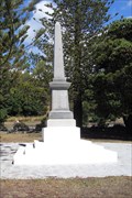 view gallery view galleryE72.3 km |  Kaikoura's Combined War Memorial, Kaikoura, New Zealand. Kaikoura's Combined War Memorial, Kaikoura, New Zealand.
in Obelisks This obelisk forms the top part of the Combined War Memorial in Kaikoura, New Zealand. posted by: greysman location: South Island, New Zealand date approved: 03/23/2011 last visited: 02/13/2016 |
 view gallery view galleryE72.3 km |  Kaikoura's Combined War Memorial, Kaikoura, New Zealand. Kaikoura's Combined War Memorial, Kaikoura, New Zealand.
in World War I Memorials and Monuments The combined War Memorial for the County of Kaikoura stands in a grove of trees, near an avenue of whalebones, between the sea and the Esplanade. posted by: greysman location: South Island, New Zealand date approved: 03/22/2011 last visited: 02/13/2016 |
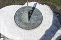 view gallery view galleryE72.4 km |  Thomas Brent Smith, The Esplanade, Kaikoura, New Zealand. Thomas Brent Smith, The Esplanade, Kaikoura, New Zealand.
in Sundials A commemorative sundial placed in remembrance of Thomas Brent Smith, died 2003, by his parents, sisters, and their families. posted by: greysman location: South Island, New Zealand date approved: 03/20/2011 last visited: never |
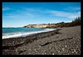 view gallery view galleryE72.4 km |  Kaikoura Beach, New Zealand Kaikoura Beach, New Zealand
in Beaches An unremarkable beach on New Zealand's South Island. posted by: Riblit location: South Island, New Zealand date approved: 11/04/2010 last visited: 04/03/2013 |
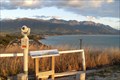 view gallery view galleryE72.6 km |  Whale Watch Coin-opp Monocular, Kakoura Peninsula, New Zealand Whale Watch Coin-opp Monocular, Kakoura Peninsula, New Zealand
in Coin-Op Binoculars A coin-operated monocular with great views over Kaikoura and the Kaikoura Coastal Range with high point being Puhi Puhi. There is a panoramic picture with points of interest marked. posted by: greysman location: South Island, New Zealand date approved: 03/22/2011 last visited: 04/03/2013 |
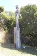 view gallery view galleryE73.9 km |  Pou Tangaroa, Kaikoura, New Zealand Pou Tangaroa, Kaikoura, New Zealand
in Maori Historic Sites Tangaroa is the God of the Sea who overlooks this Pou, the Marker, that tells the story of this place. posted by: greysman location: South Island, New Zealand date approved: 03/23/2011 last visited: 03/25/2017 |
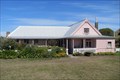 view gallery view galleryE73.9 km |  OLDEST - Building in Kaikoura, New Zealand. OLDEST - Building in Kaikoura, New Zealand.
in Superlatives Fyffe House is Kaikoura's oldest surviving building, it has changed little since the 1860s. Painted in its original pink, it is all that remains of the Kaikoura whaling industry. posted by: greysman location: South Island, New Zealand date approved: 03/26/2011 last visited: never |
|