 view gallery view gallery N1.8 km N1.8 km
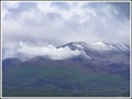
|   "Fear at Tongariro". Mt Tongariro. Nth Is. New Zealand. "Fear at Tongariro". Mt Tongariro. Nth Is. New Zealand.
in News Article Locations The front page news item in our local newspaper reported the recent eruption of Te Maari Craters on Mt Tongariro. posted by:  Punga and Paua Punga and Paua location: North Island, New Zealand date approved: 01/29/2013 last visited: 03/08/2024 |
 view gallery view gallery SW3.4 km SW3.4 km
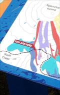
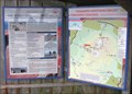
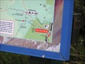
|  'You are here" on the Tongariro Corssing (New Zealand) 'You are here" on the Tongariro Corssing (New Zealand)
in 'You Are Here' Maps A Sign that is along the Tongariro Alpine Crossing.
The sign is also used in a Earthcache called Ngaruhoe - Mt Doom GC24VXZ posted by: nzkeko location: North Island, New Zealand date approved: 02/18/2012 last visited: 03/08/2024 |
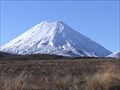 view gallery view gallerySW3.9 km |  Mt Ngauruhoe. North Island. New Zealand. Mt Ngauruhoe. North Island. New Zealand.
in Mountain Summits Mt Ngauruhoe is the almost perfect symmetrical cone-shaped volcano in Tongariro National Park in the Central North Island. posted by: Punga and Paua location: North Island, New Zealand date approved: 06/05/2009 last visited: 03/08/2024 |
 view gallery view gallerySW4 km |  Mt Ngauruhoe. North Island. New Zealand. Mt Ngauruhoe. North Island. New Zealand.
in Volcano Watching Mt Ngauruhoe is around 2,500 years old and is the youngest of the three volcanoes in the Tongariro National Park. On average Mt Ngauruhoe has erupted once in every nine years however the last major eruption took place in 1975. posted by: Punga and Paua location: North Island, New Zealand date approved: 07/23/2008 last visited: 03/08/2024 |
 view gallery view gallery W5 km W5 km
|  Tongariro Crossing Boardwalk, Central North Island. New Zealand. Tongariro Crossing Boardwalk, Central North Island. New Zealand.
in Non-Coastal Boardwalks This section of Boardwalk forms part of the famous great walk, The Tongariro Crossing, which crosses the volcanic Tongariro National Park in the centre of the North Island. posted by: Punga and Paua location: North Island, New Zealand date approved: 11/07/2019 last visited: 03/08/2024 |
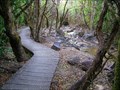 view gallery view galleryN5.8 km | Ketetahi Track Boardwalk on Mt Tongariro. North Is. New Zealand. in Non-Coastal Boardwalks A small section of boardwalk along a walking track on the slopes of Mt Tongariro. posted by: Punga and Paua location: North Island, New Zealand date approved: 03/11/2021 last visited: 03/08/2024 |
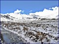 view gallery view galleryW6 km |  Mangatepopo Valley in winter, Tongariro National Park. North Island, New Zealand. Mangatepopo Valley in winter, Tongariro National Park. North Island, New Zealand.
in Scenic Overlooks Completely surrounded by the beautiful volcanic mountains in the Central North Island, this scenic winter overlook gives stunning 360 degree views from the walking track to the Mangatepopo Hut. posted by: Punga and Paua location: North Island, New Zealand date approved: 07/27/2020 last visited: 03/08/2024 |
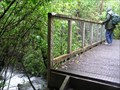 view gallery view galleryN6.3 km |  Footbridge, Tongariro Alpine Crossing. New Zealand. Footbridge, Tongariro Alpine Crossing. New Zealand.
in Hiking Path Footbridges A footbridge at the Ketetahi end of the famous Tongariro Alpine Crossing over Mt Tongariro. posted by: Punga and Paua location: North Island, New Zealand date approved: 10/04/2009 last visited: 03/08/2024 |
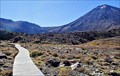
 view gallery view galleryW7.6 km |  Tongariro Alpine Crossing. New Zealand. Tongariro Alpine Crossing. New Zealand.
in Hiking and walking trailheads The Tongariro Alpine Crossing is a world-renowned trek, rated as the best one day trek in New Zealand and listed by many as one of the top 10 day treks in the world. posted by: Punga and Paua location: North Island, New Zealand date approved: 08/29/2009 last visited: 03/08/2024 |
 view gallery view galleryW8.5 km | View from on top of Pukeonake. Tongariro National Park. North Is. New Zealand. in Scenic Overlooks Pukeonake 4,019ft / 1,225m is a low scoria cone with a U shaped crater, sitting amongst the other big volcanoes in the Tongariro National Park.
From the top, you can enjoy awesome views of the mountains. posted by: Punga and Paua location: North Island, New Zealand date approved: 10/19/2020 last visited: 10/19/2020 |
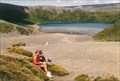 view gallery view gallerySW9 km | Tama Lakes Lookout. Tongariro National Park. North Is. New Zealand. in Scenic Overlooks A 5-6 hr return walk across undulating tussock land will take you to this stunning viewpoint of the Lower Tama Lake on the Tama Lakes track at the saddle between Mt Ruapehu and Mt Ngauruhoe. posted by: Punga and Paua location: North Island, New Zealand date approved: 07/29/2020 last visited: 07/29/2020 |
 view gallery view gallery NE10.9 km NE10.9 km
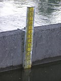
|  Poutu Dam River Gauge. Rotoaira. New Zealand. Poutu Dam River Gauge. Rotoaira. New Zealand.
in River Gauges A river gauge at the Poutu Dam measures water levels in the Rotoaira Channel at Lake Rotoaira. posted by: Punga and Paua location: North Island, New Zealand date approved: 09/13/2009 last visited: 11/13/2010 |
 view gallery view gallerySW11.3 km | Taranaki Falls View. Tongariro National Park. New Zealand. in Scenic Overlooks A stunning viewpoint of Taranaki Falls, a waterfall cascading over an old lava flow, in the Tongariro National Park. posted by: Punga and Paua location: North Island, New Zealand date approved: 10/07/2020 last visited: 10/07/2020 |
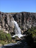 view gallery view gallerySW11.4 km |  Taranaki Falls. Tongariro National Park. New Zealand. Taranaki Falls. Tongariro National Park. New Zealand.
in Waterfalls Taranaki Falls is a stunning waterfall cascading over an old lava flow in the Tongariro National Park. posted by: Punga and Paua location: North Island, New Zealand date approved: 04/29/2014 last visited: 11/10/2009 |
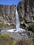 view gallery view gallerySW11.4 km |  Falls over a Lava Flow. Tongariro National Park. New Zealand. Falls over a Lava Flow. Tongariro National Park. New Zealand.
in Places of Geologic Significance The Taranaki Falls tumble over the edge of a large lava flow that erupted from the volcano of Mt Ruapehu 15,000 years ago. posted by: Punga and Paua location: North Island, New Zealand date approved: 09/13/2009 last visited: 12/01/2010 |
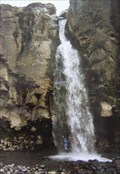 view gallery view gallerySW11.4 km |  STAND Under A Waterfall (fully clothed and dry). STAND Under A Waterfall (fully clothed and dry).
in Photo Goals To successfully complete this challenge you need to be able to walk behind the falling water to STAND UNDER a waterfall and have a photo taken of yourself (fully clothed and dry)underneath and behind the curtain of falling water. posted by: Punga and Paua location: North Island, New Zealand date approved: 05/06/2009 last visited: 04/16/2023 |
 view gallery view gallery NW11.9 km NW11.9 km
|  Battle of Te Porere. Central Plateau. New Zealand. Battle of Te Porere. Central Plateau. New Zealand.
in Battlefields The redoubts at Te Porere contain the earthworks of a Maori fortification built by the prophet and warrior Te Kooti and is the site of the last major engagement of the New Zealand Wars on 4th October 1869. posted by: Punga and Paua location: North Island, New Zealand date approved: 03/08/2010 last visited: 03/08/2010 |
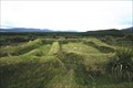 view gallery view galleryNW11.9 km |  Te Porere Redoubt. Central Plateau. North Is. New Zealand. Te Porere Redoubt. Central Plateau. North Is. New Zealand.
in Maori Historic Sites Te Porere contains the earthworks of a Maori fortification built by the prophet and warrior Te Kooti and is the site of the last major engagement of the New Zealand Wars in October 1869. posted by: Punga and Paua location: North Island, New Zealand date approved: 11/23/2008 last visited: 11/23/2008 |
 view gallery view gallery SE11.9 km SE11.9 km
| Tongariro Northern Circuit, Waihohonu. Desert Rd. North Is. New Zealand. in 'You Are Here' Maps You Are Here - at the Waihohonu entrance to the Tongariro Northern Circuit tramping track around the mountains of the Tongariro National Park in the Central North Island of New Zealand. posted by: Punga and Paua location: North Island, New Zealand date approved: 07/27/2015 last visited: 07/27/2015 |
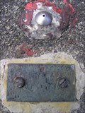 view gallery view gallerySE11.9 km |  Survey Marker at the Waihohonu Tunnel. Central Plateau. New Zealand. Survey Marker at the Waihohonu Tunnel. Central Plateau. New Zealand.
in Australia/NZ Benchmarks A metal survey marker for the Tongariro Hydro Scheme is set into the concrete of a hydro structure near the Rangipo Dam on the Volcanic Plateau. posted by: Punga and Paua location: North Island, New Zealand date approved: 02/14/2010 last visited: 02/14/2010 |
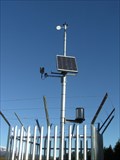 view gallery view galleryW12.4 km |  Solar powered Weather Station. Central Plateau. New Zealand. Solar powered Weather Station. Central Plateau. New Zealand.
in Solar Power A weather station alongside SH.47 in a remote area of the central North Island runs by solar power panels. posted by: Punga and Paua location: North Island, New Zealand date approved: 04/06/2010 last visited: 04/08/2010 |
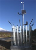 view gallery view galleryW12.4 km |  Mountain Weather Station. SH.47. Central North Is. New Zealand. Mountain Weather Station. SH.47. Central North Is. New Zealand.
in Weather Stations A MetService automatic weather station is situated beside SH.47 in the Central North Island of New Zealand. posted by: Punga and Paua location: North Island, New Zealand date approved: 06/03/2009 last visited: 12/01/2010 |
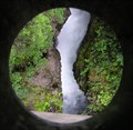 view gallery view gallery E12.4 km E12.4 km
|  The Force of Nature. Central North Is. New Zealand. The Force of Nature. Central North Is. New Zealand.
in Best Kept Secrets Not many people venture off the main highway to discover the spectacular secret hidden within this narrow gorge. posted by: Punga and Paua location: North Island, New Zealand date approved: 07/22/2008 last visited: 07/27/2008 |
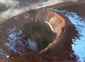
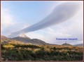
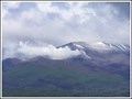 view gallery view galleryN12.6 km | Te Maari Craters, Mt Tongariro. New Zealand. in Volcano Watching After laying dormant for 115 years, Te Maari craters erupted in August and November of 2012 and are still billowing steam and gas from the vents, providing interesting viewing for volcano watchers. posted by: Punga and Paua location: North Island, New Zealand date approved: 01/25/2013 last visited: 01/29/2013 |
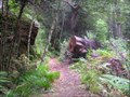 view gallery view galleryE12.9 km | Tree Trunk Gorge Track. Central Plateau. New Zealand. in Scenic Hikes This lovely walk through mountain beech forest follows an old survey track along the side of the upper Tongariro River in the Kaimanawa Forest Park. posted by: Punga and Paua location: New Zealand date approved: 07/29/2008 last visited: 04/13/2008 |
|