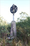
 view gallery view gallery N20.9 km N20.9 km
|   Raspberry Trig - Styx River State Forest NSW Raspberry Trig - Styx River State Forest NSW
in Australian Trig Points An intact Trig point on a 4wd track in the Styx River State Forest. Official COde: TS6380. posted by:  John1041 John1041 location: New South Wales, Australia date approved: 08/19/2018 last visited: 12/16/2018 |
 view gallery view gallery S27.2 km S27.2 km
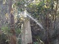
| Drain trig, Kunderang Wilderness Area, Werrikimbe, NSW in Australian Trig Points Situated not far off a dirt track leading into the Kunderang Wilderness Area, on the northern part of the Werrikimbe National Park is this concrete pedestal trig, with intact post, vanes, and name plate. Official Code: TS6304 posted by:  Grahame Cookie Grahame Cookie location: New South Wales, Australia date approved: 11/16/2015 last visited: never |
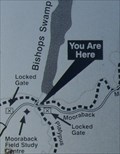
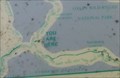 view gallery view galleryS27.4 km |  Kunderang Wilderness UR Here, Werrikimbe NP, NSW, Australia Kunderang Wilderness UR Here, Werrikimbe NP, NSW, Australia
in 'You Are Here' Maps At the junction of Racecourse Trail, and Youdales West Trail, is a dilapidated map from the National Parks and Wildlife Service, showing where you are in the Kunderang Wilderness - Werrikimbe National Park. posted by: Grahame Cookie location: New South Wales, Australia date approved: 10/24/2016 last visited: never |
 view gallery view galleryN28.3 km | Styx trig - Styx River State Forest, Jeogla, NSW in Australian Trig Points Right beside a dirt road, called Raspberry Road, in the Styx River State Forest, is this concrete pedestal trig. Official Code: TS5827; Official Name: Styx. posted by: Grahame Cookie location: New South Wales, Australia date approved: 03/18/2018 last visited: 08/19/2018 |
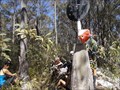
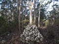 view gallery view galleryS29.6 km | Melville trig, Yarrowitch, NSW in Australian Trig Points About a kilometre west of Racecourse Trail (or Youdales Trail), in the Werrikimbe NP and Yarrowitch regions is this rock cairn trig.
Official code: TS3054. Elevation: +/- 1,050 metres. posted by: Grahame Cookie location: New South Wales, Australia date approved: 11/24/2016 last visited: never |
 view gallery view galleryS31.2 km | URHere, Platypus Pools Walk, Werrikimbe NP, NSW, Australia in 'You Are Here' Maps Just over the rise of the Mooraback Camping area, in the Werrikimbe National Park (below the Service Hut), is the start of the Platypus Pools Walk. Keep your eyes open for kangaroos as well. posted by: Grahame Cookie location: New South Wales, Australia date approved: 03/21/2016 last visited: never |
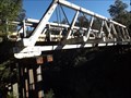 view gallery view galleryN31.7 km |  Styx River Wood Truss Bridge - Jeogla, NSW, Australia Styx River Wood Truss Bridge - Jeogla, NSW, Australia
in Truss Bridges On the Armidale-Kempsey Road, between Kempsey, and Waterfall Way, there is this now bypassed wooden, Allan-style, Truss Bridge. posted by: Grahame Cookie location: New South Wales, Australia date approved: 03/19/2018 last visited: never |
 view gallery view galleryN31.7 km |  Styx River Orphaned Bridge - Jeogla, NSW, Australia Styx River Orphaned Bridge - Jeogla, NSW, Australia
in Orphaned Bridges On the Armidale-Kempsey Road, between Kempsey, and Waterfall Way, there is this now bypassed wooden Truss Bridge. posted by: Grahame Cookie location: New South Wales, Australia date approved: 03/29/2018 last visited: never |
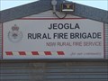 view gallery view galleryN33.5 km |  Jeogla Rural Fire Brigade Jeogla Rural Fire Brigade
in Firehouses A simple shed, for the local volunteer fire fighters of Jeogla. posted by: Grahame Cookie location: New South Wales, Australia date approved: 03/25/2018 last visited: never |
 view gallery view galleryN34.8 km |  Oaky River - 1955 - Jeogla, NSW, Australia Oaky River - 1955 - Jeogla, NSW, Australia
in Bridge Date Stones and Plaques This multi-span concrete bridge over the Oaky River on Kempsey Road was built in 1955. posted by: Grahame Cookie location: New South Wales, Australia date approved: 05/17/2018 last visited: never |
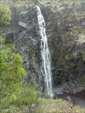
 view gallery view galleryN39.4 km |  Main Falls Lookout, Wollomombi Falls - Wollomombi, NSW Main Falls Lookout, Wollomombi Falls - Wollomombi, NSW
in Scenic Overlooks A cantilevered platform overhanging the Wollomombi Gorge gives views of dramatic cliffs & the Wollomombi Falls, one of the highest in Australia. posted by: Tuena location: New South Wales, Australia date approved: 05/14/2023 last visited: never |
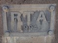 view gallery view galleryN40.6 km | Chandler River - 1994 - Wollombi, NSW, Australia in Bridge Date Stones and Plaques This multi-span concrete bridge on Grafton Road over the Chandler River was built in 1994. posted by: Grahame Cookie location: New South Wales, Australia date approved: 05/17/2018 last visited: never |
 view gallery view galleryN40.7 km |  Goroka - Wollomombi, NSW, Australia Goroka - Wollomombi, NSW, Australia
in Named Farms and Ranches At the dead-end of Wollomombi Village Road, beside the Waterfall Way is this unusually named property. posted by: Grahame Cookie location: New South Wales, Australia date approved: 08/02/2017 last visited: never |
 view gallery view gallery NW40.9 km NW40.9 km
|  Hillgrove (former), NSW, 2350 Hillgrove (former), NSW, 2350
in Australia Post Offices The former post office in a tin and gold mining town posted by: blingg location: New South Wales, Australia date approved: 07/30/2022 last visited: never |
 view gallery view gallery SW40.9 km SW40.9 km
|  Apsley Falls, NSW, Australia Apsley Falls, NSW, Australia
in Waterfalls Apsley Falls are a two-tiered cascade, that drops a total of 123 m, with the longest drop being 65 m. Discovered in 1818 by John Oxley, who named the Apsley River, which descends through a sheer sided gorge. posted by: Grahame Cookie location: New South Wales, Australia date approved: 08/14/2015 last visited: 07/24/2022 |
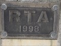 view gallery view galleryN41 km | Ponds Creek - 1984 - NSW, Australia in Bridge Date Stones and Plaques This is one of a couple of concrete bridges with a dated plaque on the Waterfall Way, between Dorrigo and Armidale, NSW. It was built by the Roads and Traffic Authority - "Department of Main Roads". posted by: Grahame Cookie location: New South Wales, Australia date approved: 04/12/2016 last visited: never |
 view gallery view galleryN41.4 km |  Wollomombi Rest Area - Wollomombi, NSW, Australia Wollomombi Rest Area - Wollomombi, NSW, Australia
in Highway Rest Areas Off of Waterfall Way, between Grafton and Armidale, is this pleasant Rest Area of Wollomombi. posted by: Grahame Cookie location: New South Wales, Australia date approved: 03/16/2018 last visited: never |
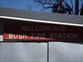 view gallery view galleryN41.4 km | Wollomombi Bush Fire Station in Firehouses In the quiet locality of Wollomombi, in the northern tablelands of NSW, is this volunteer fire fighting unit. posted by: Grahame Cookie location: New South Wales, Australia date approved: 03/25/2018 last visited: 07/31/2019 |
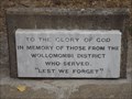 view gallery view galleryN41.4 km |  Wollomombi Village - Lest We Forget, NSW, Australia Wollomombi Village - Lest We Forget, NSW, Australia
in Non-Specific Veteran Memorials This "Lest We Forget", "To God be the Glory" memorial plaque is in the yard of the original (and only) church of the small Wollomombi Village, about 40 east of Armidale. It commemorates those who served from the District. posted by: Grahame Cookie location: New South Wales, Australia date approved: 03/29/2016 last visited: never |
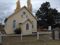
 view gallery view galleryN41.4 km |  1926 - St John's Wollomombi Church, Wollomombi, NSW, Australia 1926 - St John's Wollomombi Church, Wollomombi, NSW, Australia
in Dated Buildings and Cornerstones This Presbyterian was built in 1926, for the small rural community of Wollomombi, on the northern tablelands of NSW. posted by: Grahame Cookie location: New South Wales, Australia date approved: 08/03/2017 last visited: never |
 view gallery view galleryN41.4 km |  St John's, Wollomombi, NSW, Australia St John's, Wollomombi, NSW, Australia
in Presbyterian Churches This is a well presented, original (1926) wooden building on the main road for the Wollomombi Village, about 38 km east of Armidale. posted by: Grahame Cookie location: New South Wales, Australia date approved: 04/11/2016 last visited: never |
 view gallery view galleryN41.4 km |  Wollomombi Presbyterian Church, NSW, Australia Wollomombi Presbyterian Church, NSW, Australia
in This Old Church Wollomombi is such a small 'locality' that the St John's Presbyterian Church is used for the Presbyterians on the 3rd Sunday of each month at 3 pm; but also used by the Anglican Church on the 2nd Sunday of each month (also at 3pm). posted by: Grahame Cookie location: New South Wales, Australia date approved: 03/28/2016 last visited: 07/31/2019 |
 view gallery view galleryN41.4 km | Wollomombi LPO, NSW - 2350 in Australia Post Offices On a local/side road, is the Licenced Post Office, for the locality of Wollomombi, in the northern tablelands of NSW. posted by: Grahame Cookie location: New South Wales, Australia date approved: 03/25/2018 last visited: 07/19/2022 |
 view gallery view galleryN41.4 km |  Wollomombi General Store, NSW, Australia Wollomombi General Store, NSW, Australia
in The Local Neighborhood Grocer Off of the main road, in the village of Wollomombi, is this Local Neighborhood Grocer. posted by: Grahame Cookie location: New South Wales, Australia date approved: 03/25/2018 last visited: 07/19/2022 |
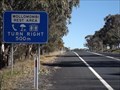
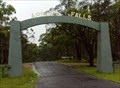 view gallery view gallerySW42 km |  Apsley Falls, NSW, Australia Apsley Falls, NSW, Australia
in Freestanding Arches This freestanding arch off the Oxley Highway is for the entry road to Apsley Falls, a pair of waterfalls (65 m and 58 m high), about a kilometre away, in the Oxley Wild Rivers National Park. posted by: Grahame Cookie location: New South Wales, Australia date approved: 07/16/2015 last visited: 05/03/2023 |
|