 view gallery view gallery S22.2 km S22.2 km
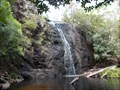
|   Boundary Falls - Glen Innes, NSW Boundary Falls - Glen Innes, NSW
in Waterfalls Boundary Falls are in Washpool National Park 63 kilometres east of Glen Innes. posted by:  Tuena Tuena location: New South Wales, Australia date approved: 02/24/2017 last visited: 01/28/2019 |
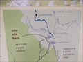 view gallery view galleryS22.4 km |  You Are Here - Boundary Falls Picnic Area, Washpool National Park, Glen Innes, NSW You Are Here - Boundary Falls Picnic Area, Washpool National Park, Glen Innes, NSW
in 'You Are Here' Maps A You Are Here map in the Boundary Falls picnic area. posted by: Tuena location: New South Wales, Australia date approved: 02/23/2017 last visited: 01/28/2019 |
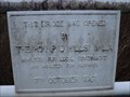
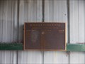
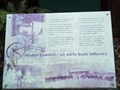 view gallery view galleryS22.4 km |  Wades Sawmill - Boundary Falls, NSW, Australia Wades Sawmill - Boundary Falls, NSW, Australia
in Australian Historical Markers The Historical Marker stands in front of the old steam engine of the sawmill. posted by: Grahame Cookie location: New South Wales, Australia date approved: 06/15/2019 last visited: never |
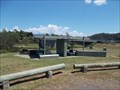
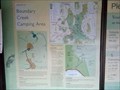 view gallery view galleryS22.5 km |  Boundary Creek Camping Area - NSW, Australia Boundary Creek Camping Area - NSW, Australia
in Campgrounds While you might expect free camping, there are costs involved at the Boundary Falls camp site. posted by: Grahame Cookie location: New South Wales, Australia date approved: 06/15/2019 last visited: never |
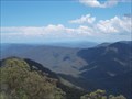 view gallery view galleryS24.5 km |  Raspberry Lookout - Glen Innes, NSW Raspberry Lookout - Glen Innes, NSW
in Scenic Roadside Look-Outs Raspberry Lookout is named after the native plant which grows in the area. posted by: Tuena location: New South Wales, Australia date approved: 02/26/2017 last visited: 12/20/2017 |
 view gallery view galleryS24.5 km | You Are Here - Raspberry Lookout, Gibraltar Range National Park, Glen Innes, NSW in 'You Are Here' Maps A You Are Here map at the Raspberry Lookout which has rugged mountain views. posted by: Tuena location: New South Wales, Australia date approved: 02/23/2017 last visited: 12/20/2017 |
 view gallery view gallery SE33.5 km SE33.5 km
|  Mann River - 1961 - Jackadgery, NSW, Australia Mann River - 1961 - Jackadgery, NSW, Australia
in Bridge Date Stones and Plaques The two-lane concrete bridge over the Mann River at Jackadgery was built in 1961. posted by: Grahame Cookie location: New South Wales, Australia date approved: 06/23/2019 last visited: never |
 view gallery view gallerySE33.6 km |  Lollback Rest Area - Jackadgery, NSW Lollback Rest Area - Jackadgery, NSW
in Highway Rest Areas A rest area beside the Gwydir Highway which connects Grafton & Glen Innes. posted by: Tuena location: New South Wales, Australia date approved: 02/24/2017 last visited: 08/25/2018 |
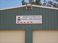 view gallery view gallery W34 km W34 km
|  Sandy Flat/Bolivia Rural Fire Brigade Sandy Flat/Bolivia Rural Fire Brigade
in Firehouses A Rural Fire Brigade at the locality of Sandy Flat. posted by: Tuena location: New South Wales, Australia date approved: 05/30/2015 last visited: 04/17/2016 |
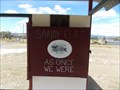 view gallery view galleryW34 km |  As Once We Were - Sandy Flat, NSW As Once We Were - Sandy Flat, NSW
in Signs of History An information bay shelters a steel & perspex booklet which outlines an historical account of Sandy Flat. posted by: Tuena location: New South Wales, Australia date approved: 07/31/2015 last visited: 04/16/2016 |
 view gallery view gallery NW41 km NW41 km
|  Honour Roll - Bungulla, NSW Honour Roll - Bungulla, NSW
in World War I Memorials and Monuments An Honour Roll in the locality of Bungulla. posted by: Tuena location: New South Wales, Australia date approved: 06/23/2015 last visited: 04/16/2016 |
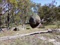
 view gallery view galleryW42.2 km |  Balancing Rocks - Deepwater, NSW, Australia Balancing Rocks - Deepwater, NSW, Australia
in Nature's Balanced Rocks On the eastern side of the New England Highway, north of Deepwater, is a 'wall' of stacked and Balancing Rocks. posted by: Grahame Cookie location: New South Wales, Australia date approved: 07/01/2019 last visited: never |
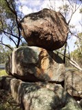
 view gallery view galleryW42.3 km | Eternity - Balancing Rocks - Deepwater, NSW, Australia in Nature's Balanced Rocks Besides the New England Highway is this 'egg-shaped' Balancing Rock. posted by: Grahame Cookie location: New South Wales, Australia date approved: 07/01/2019 last visited: never |
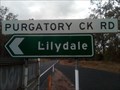 view gallery view gallerySE43.6 km |  Purgatory Creek Road - Jackadgery, NSW, Australia Purgatory Creek Road - Jackadgery, NSW, Australia
in Man-made Devilish Locations The side-road from Gwydir Highway [B76] at Jackadgery is called PURGATORY CREEK ROAD. posted by: Grahame Cookie location: New South Wales, Australia date approved: 06/17/2019 last visited: never |
 view gallery view galleryNW43.9 km |  Tenterfield, NSW, Australia; Pop. 3,300 Tenterfield, NSW, Australia; Pop. 3,300
in Population Signs Tenterfield, NSW, "the Birthplace of a Nation", was where Henry Parkes gave his speech in 1886 outlining the need to ‘unite and create a great national government for all Australia’.
The Welcome sign on the Southern entry shows population as 3,300 posted by: Grahame Cookie location: New South Wales, Australia date approved: 02/03/2015 last visited: never |
 view gallery view galleryNW43.9 km |  Tenterfield, NSW, Australia; Elevation - 850m Tenterfield, NSW, Australia; Elevation - 850m
in Elevation Signs Tenterfield, NSW, "the Birthplace of a Nation", was where Henry Parkes gave his speech in 1886 outlining the need to ‘unite and create a great national government for all Australia’.
The Welcome sign on the Southern entry shows elevation as 850 m. posted by: Grahame Cookie location: New South Wales, Australia date approved: 02/01/2015 last visited: never |
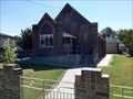
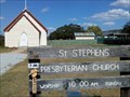 view gallery view galleryNW44.3 km |  St Stephens - Tenterfield, NSW, Australia St Stephens - Tenterfield, NSW, Australia
in Presbyterian Churches This Presbyterian Church, built in 1884, in Tenterfield has some association with local history makers. posted by: Grahame Cookie location: New South Wales, Australia date approved: 07/10/2019 last visited: never |
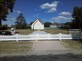 view gallery view galleryNW44.3 km |  St Stephens - Tenterfield, NSW, Australia St Stephens - Tenterfield, NSW, Australia
in This Old Church This wood-clad building was erected as a temporary church in 1884. posted by: Grahame Cookie location: New South Wales, Australia date approved: 07/10/2019 last visited: never |
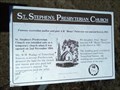 view gallery view galleryNW44.3 km | St Stephen's Presbyterian Church - Tenterfield, NSW, Australia in Australian Historical Markers This printed metal plaque is beside the grass footpath at the front of the Church. posted by: Grahame Cookie location: New South Wales, Australia date approved: 01/31/2019 last visited: never |
 view gallery view galleryNW44.3 km |  1885 - Residence - Tenterfield, NSW, Australia 1885 - Residence - Tenterfield, NSW, Australia
in Dated Buildings and Cornerstones This building looks like it would have been a council hall, and in fact it was the Oddfellows building for Tenterfield. posted by: Grahame Cookie location: New South Wales, Australia date approved: 01/31/2019 last visited: never |
 view gallery view galleryNW44.3 km |  Tenterfield SDA Church, NSW, Australia Tenterfield SDA Church, NSW, Australia
in Seventh-day Adventist Churches This brick building is the Adventist Church for Tenterfield and areas. posted by: Grahame Cookie location: New South Wales, Australia date approved: 02/02/2019 last visited: never |
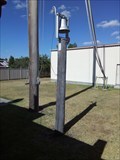 view gallery view galleryNW44.3 km |  Fire Station Bell Tower - Tenterfield, NSW, Australia Fire Station Bell Tower - Tenterfield, NSW, Australia
in Bell Towers This basic, stand-alone Bell Tower is behind the Fire Station for Tenterfield, behind a Colorbond fence. posted by: Grahame Cookie location: New South Wales, Australia date approved: 02/04/2019 last visited: never |
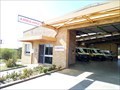
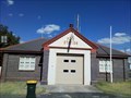 view gallery view galleryNW44.3 km | Fire Station in Firehouses This Firehouse is for the Fire and Rescue Station of Tenterfield. posted by: Grahame Cookie location: New South Wales, Australia date approved: 06/16/2019 last visited: never |
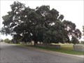 view gallery view galleryNW44.4 km |  Cork Tree, Tenterfield, NSW Cork Tree, Tenterfield, NSW
in Exceptional Trees This cork tree is believed to be the largest in Australia. posted by: Tuena location: New South Wales, Australia date approved: 06/23/2015 last visited: 01/12/2020 |
 view gallery view galleryNW44.4 km |  Ambulance Station - Tenterfield, NSW, Australia Ambulance Station - Tenterfield, NSW, Australia
in Paramedic Stations This Ambulance Station for Tenterfield was opened in 1981. posted by: Grahame Cookie location: New South Wales, Australia date approved: 07/04/2019 last visited: never |
|