 view gallery view gallery SW0 km SW0 km
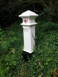
|   189, Downe 189, Downe
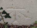
in London Coal Tax Posts Post 189 between Downe and Cudham. This lane seems variously to be called "Cudham Rd" and "Downe Rd". Depends which way you're going I suppose. "24 & 25 VICT CAP 42" posted by:  Team Sieni Team Sieni location: South East England, United Kingdom date approved: 08/27/2007 last visited: 09/23/2013 |
 view gallery view gallery SE1 km SE1 km
|  The Blacksmith's Arms - Cudham, Kent, UK The Blacksmith's Arms - Cudham, Kent, UK
in Pictorial Pub Signs The Blacksmith's Arms is on the north east side of Cudham Lane South in the Kent Village of Cudham. posted by: Master Mariner location: London, United Kingdom date approved: 09/30/2013 last visited: never |
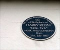 view gallery view gallerySE1.1 km |  Harry Relph "Little Tich" Cudham, Kent, UK Harry Relph "Little Tich" Cudham, Kent, UK
in Blue Plaques A plaque on the Blacksmiths Arms in Cudham, the birthplace of the musichall comedian Harry Relph, known as "Little Tich". posted by: Team Sieni location: United Kingdom date approved: 04/14/2013 last visited: 09/23/2013 |
 view gallery view gallery NW2.6 km NW2.6 km
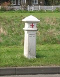
| 186, Leaves Green in London Coal Tax Posts Beside the on the Green at Leaves Green on the W side of the A233 posted by: Team Sieni location: South East England, United Kingdom date approved: 04/01/2007 last visited: 09/28/2013 |
 view gallery view gallery W2.9 km W2.9 km
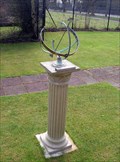
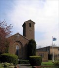
|  Biggin Hill RAF Chapel Biggin Hill RAF Chapel
in Sundials Presented In Memory Of WG. CDR. IAN McCOMBIE 14.9.1923 - 26.2.2002 posted by: Team Sieni location: South East England, United Kingdom date approved: 04/01/2007 last visited: 09/28/2013 |
 view gallery view galleryW2.9 km |  1951 - RAF Chapel - Biggin Hill, Kent, UK 1951 - RAF Chapel - Biggin Hill, Kent, UK
in Dated Buildings and Cornerstones The corber stone is on the west face of Saint George's Royal Air Force Chapel of Remembrance at Biggin Hill posted by: Master Mariner location: London, United Kingdom date approved: 09/28/2013 last visited: never |
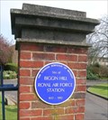 view gallery view galleryW2.9 km | Biggin Hill RAF Station in Blue Plaques Biggin Hill was an important RAF station during the Battle of Britain. posted by: Team Sieni location: South East England, United Kingdom date approved: 04/01/2007 last visited: 09/28/2013 |
 view gallery view galleryW2.9 km |  Biggin Hill RAF Station Biggin Hill RAF Station
in Static Aircraft Displays Replica Spitfire and Hurricane act as gate guardians as St George's RAF Chapel, Biggin Hill.
Biggin Hill was an important Royal Air Force base during the Battle of Britain, in summer 1940. It is now a commercial airport. posted by: Team Sieni location: South East England, United Kingdom date approved: 04/01/2007 last visited: 09/28/2013 |
 view gallery view galleryW2.9 km |  Biggin Hill Royal Air Force Station Biggin Hill Royal Air Force Station
in World War II Sites Biggin Hill was an important Royal Air Force base during the Battle of Britain, in the summer of 1940. posted by: Team Sieni location: South East England, United Kingdom date approved: 04/01/2007 last visited: 09/28/2013 |
 view gallery view gallery NE3.2 km NE3.2 km
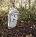
|  A 21 Milestone, Nr Pratt's Bottom, Kent, UK A 21 Milestone, Nr Pratt's Bottom, Kent, UK
in Milestones A nicely restored milestone beside the A21 Sevenoaks Rd. posted by: Team Sieni location: South East England, United Kingdom date approved: 01/05/2014 last visited: 05/09/2015 |
 view gallery view galleryNE3.2 km |  Cut Bench Mark - Sevenoaks Road, Pratt's Bottom, Kent, UK Cut Bench Mark - Sevenoaks Road, Pratt's Bottom, Kent, UK
in U.K. and Ireland Trigpoints This mark is cut into a milestone on the south side of Sevenoaks Road to the west of Pratt's Bottom. posted by: Master Mariner location: London, United Kingdom date approved: 03/30/2014 last visited: 05/09/2015 |
 view gallery view galleryNE3.2 km |  Cut Bench Mark - Sevenoaks Road, Pratt's Bottom, Kent, UK Cut Bench Mark - Sevenoaks Road, Pratt's Bottom, Kent, UK
in European Historic Survey Stones, Monuments and Benchmarks This mark is cut into a milestone on the south side of Sevenoaks Road to the west of Pratt's Bottom. posted by: Master Mariner location: London, United Kingdom date approved: 04/03/2014 last visited: 05/09/2015 |
 view gallery view gallerySE3.4 km |  St Katharine's Church - Knockholt, Kent, UK St Katharine's Church - Knockholt, Kent, UK
in Medieval Churches The early 12th century Anglican church of St Katharine is located on the north west side of Main Road in Knockholt. posted by: Master Mariner location: South East England, United Kingdom date approved: 09/29/2013 last visited: 08/05/2015 |
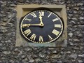 view gallery view gallerySE3.4 km |  St Katharine's Church - Knockholt, Kent, UK St Katharine's Church - Knockholt, Kent, UK
in Town Clocks The early 12th century Anglican church of St Katharine is located on the north west side of Main Road in Knockholt. The clock face is on the south face of the church's bell tower. posted by: Master Mariner location: South East England, United Kingdom date approved: 09/30/2013 last visited: 08/05/2015 |
 view gallery view gallerySE3.4 km |  St Katharine's Church - Knockholt, Kent, UK St Katharine's Church - Knockholt, Kent, UK
in Wikipedia Entries The early 12th century Anglican church of St Katharine is located on the north west side of Main Road in Knockholt. posted by: Master Mariner location: South East England, United Kingdom date approved: 09/29/2013 last visited: 08/05/2015 |
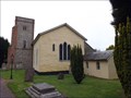 view gallery view gallerySE3.4 km |  St Katharine's Church - Knockholt, Kent, UK St Katharine's Church - Knockholt, Kent, UK
in Anglican and Episcopal Churches The early 12th century Anglican church of St Katharine is located on the north west side of Main Road in Knockholt. posted by: Master Mariner location: South East England, United Kingdom date approved: 09/29/2013 last visited: 08/05/2015 |
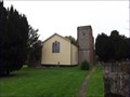 view gallery view gallerySE3.4 km |  St Katharine's Church - Knockholt, Kent, UK St Katharine's Church - Knockholt, Kent, UK
in Bell Towers The early 12th century Anglican church of St Katharine is located on the north west side of Main Road in Knockholt. The church's tower has two bells. posted by: Master Mariner location: South East England, United Kingdom date approved: 10/05/2013 last visited: 08/05/2015 |
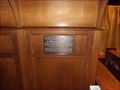 view gallery view gallerySE3.4 km |  Sir Waldron Smithers - St Katharine's Church, Knockholt, Kent, UK Sir Waldron Smithers - St Katharine's Church, Knockholt, Kent, UK
in Citizen Memorials The early 12th century Anglican church of St Katharine is located on the north west side of Main Road in Knockholt. A plaque is attached to the church's organ to commemorate the 50th anniversary of Sir Waldron Smithers being the organist. posted by: Master Mariner location: London, United Kingdom date approved: 09/29/2013 last visited: never |
 view gallery view gallerySE3.4 km |  St Katharine's Church - Knockholt, Kent, UK St Katharine's Church - Knockholt, Kent, UK
in This Old Church The early 12th century Anglican church of St Katharine is located on the north west side of Main Road in Knockholt. posted by: Master Mariner location: South East England, United Kingdom date approved: 09/27/2013 last visited: 08/05/2015 |
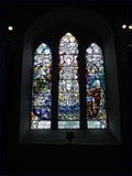 view gallery view gallerySE3.4 km |  St Katharine's Church - Knockholt, Kent, UK St Katharine's Church - Knockholt, Kent, UK
in Stained Glass Windows The early 12th century Anglican church of St Katharine is located on the north west side of Main Road in Knockholt. The church has several stained glass windows. posted by: Master Mariner location: South East England, United Kingdom date approved: 09/29/2013 last visited: never |
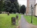 view gallery view gallerySE3.4 km |  St Katharine's Church - Knockholt, Kent, UK St Katharine's Church - Knockholt, Kent, UK
in Churchyard Cemeteries The early 12th century Anglican church of St Katharine is located on the north west side of Main Road in Knockholt. The main part of the graveyard lies to the west of the church with some graves to the east and the war memorial to the south. posted by: Master Mariner location: South East England, United Kingdom date approved: 09/30/2013 last visited: 08/05/2015 |
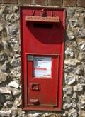 view gallery view gallerySE3.4 km |  Wall box, Main Road, Knockholt, Kent Wall box, Main Road, Knockholt, Kent
in Victorian Post Boxes A box mounted in a flint wall in the village of Knockholt. posted by: Team Sieni location: South East England, United Kingdom date approved: 08/24/2014 last visited: 08/27/2014 |
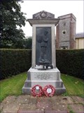 view gallery view gallerySE3.4 km |  Great War Memorial - Knockholt, Kent, UK Great War Memorial - Knockholt, Kent, UK
in World War I Memorials and Monuments This Great War memorial, to remember the men of Knockholt that dies in the 1914-1918 war, is located in the grounds of St Katharine's church in Knockholt. It is to the south of the church and adjacent Main Road that runs through the village. posted by: Master Mariner location: South East England, United Kingdom date approved: 09/29/2013 last visited: never |
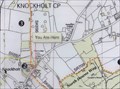 view gallery view gallerySE3.4 km |  You Are Here - St Katharine's Church, Knockholt, Kent, UK You Are Here - St Katharine's Church, Knockholt, Kent, UK
in 'You Are Here' Maps The Anglican church of St Katharine's stands on the north west side of Main Road that runs through this Kent Village. The "you are here" map is located near the church's lych gate. posted by: Master Mariner location: South East England, United Kingdom date approved: 09/26/2013 last visited: never |
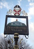 view gallery view galleryNE3.7 km |  Village Sign - Rushmore Hill, Pratt's Bottom, Bromley, UK Village Sign - Rushmore Hill, Pratt's Bottom, Bromley, UK
in Pictorial Village Signs On Rushmore Hill, on the village green. Close to the village pub and church. posted by: SignWaymarker location: London, United Kingdom date approved: 12/06/2011 last visited: 05/09/2015 |
|