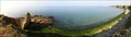
 view gallery view gallery W12.7 km W12.7 km
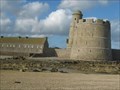
|   Fort de Tatihou,Saint-Vaast-la-Hougue,France Fort de Tatihou,Saint-Vaast-la-Hougue,France
in Military Installations Le fort de Tatihou à Saint-Vaast-la-Hougue./ Fort Tatihou in Saint-Vaast-la-Hougue. posted by:  celene37 celene37 location: Centre-Val-de-Loire, France date approved: 03/01/2018 last visited: 01/30/2023 |
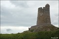
 view gallery view galleryW12.7 km |  Fort de Tatihou,Saint-Vaast-la-Hougue,France Fort de Tatihou,Saint-Vaast-la-Hougue,France
in World Heritage Sites Le fort de Tatihou à Saint-Vaast-la-Hougue./ Fort Tatihou in Saint-Vaast-la-Hougue. posted by: celene37 location: Normandie, France date approved: 02/24/2018 last visited: 01/30/2023 |
 view gallery view galleryW12.7 km |  Fort de Tatihou,Saint-Vaast-la-Hougue,France Fort de Tatihou,Saint-Vaast-la-Hougue,France
in Historic Forts Le fort de Tatihou à Saint-Vaast-la-Hougue./ Fort Tatihou in Saint-Vaast-la-Hougue. posted by: celene37 location: Centre-Val-de-Loire, France date approved: 02/23/2018 last visited: 05/08/2017 |
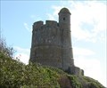 view gallery view galleryW15.3 km | Fort de La Hougue,Saint-Vaast-la-Hougue,France in Historic Forts Le Fort de La Hougue à Saint-Vaast-la-Hougue./La Hougue in Saint-Vaast-la-Hougue. posted by: celene37 location: Normandie, France date approved: 02/24/2018 last visited: 03/15/2021 |
 view gallery view galleryW15.3 km | Fortifications of Vauban: Fort de la Hogue (Normandy, France) in World Heritage Sites From a far visible tower of Fort de la Hogue - a landmark of Saint-Vaast-La-Hougue area - is one of 12 fortified objects designed by genial French military engineer Sébastien Le Prestre de Vauban, which were added to UNESCO WH List in 2008. posted by: Dorcadion Team location: Normandie, France date approved: 02/24/2010 last visited: 03/15/2021 |
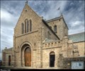
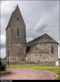
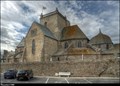 view gallery view gallery NW16.1 km NW16.1 km
|  Eglise Saint-Nicolas / Church of St. Nicolas (Barfleur, Normandy) Eglise Saint-Nicolas / Church of St. Nicolas (Barfleur, Normandy)
in This Old Church Church of St. Nicolas (Eglise Saint-Nicolas) in Barfleur, built in th first half 17th century, is the architectural dominant of this small pictoresque seaport in north of Cotentin peninsula (Normandy). posted by: Dorcadion Team location: Normandie, France date approved: 06/17/2014 last visited: 07/13/2018 |
 view gallery view galleryNW16.1 km |  Eglise Saint-Nicolas / Church of St. Nicolas (Barfleur, Normandy) Eglise Saint-Nicolas / Church of St. Nicolas (Barfleur, Normandy)
in Monuments Historiques Français Church of St. Nicolas (Eglise Saint-Nicolas) in Barfleur is the architectural dominant of this small pictoresque seaport in north of Cotentin peninsula (Normandy). posted by: Dorcadion Team location: Normandie, France date approved: 02/26/2010 last visited: 07/13/2018 |
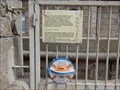
 view gallery view galleryNW16.1 km |  Point géodésique 5003001 - L'église Saint-Nicolas (Barfleur) Point géodésique 5003001 - L'église Saint-Nicolas (Barfleur)
in French Benchmarks Point géodésique - sommet du clocher (L'église Saint-Nicolas). Geodetical point (BARFLEUR I, 5003001) on the top of bell tower of Church of St. Nicolas in Barfleur (Normandy). posted by: Dorcadion Team location: Normandie, France date approved: 06/16/2014 last visited: 07/13/2018 |
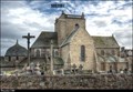
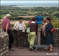 view gallery view galleryW16.7 km |  Monocular at Church of St. Petronilla in La Pernelle (Normandy) Monocular at Church of St. Petronilla in La Pernelle (Normandy)
in Coin-Op Binoculars One monocular at small platform close to Church of St. Petronilla (Église Sainte-Petronille) in La Pernelle offers great vistas over on the northeast coast of the Cotentin Peninsula in Normandy. posted by: Dorcadion Team location: Normandie, France date approved: 02/25/2010 last visited: 02/12/2012 |
 view gallery view galleryW16.9 km | Point géodésique 5039501 - L'église Sainte-Petronille (La Pernelle) in French Benchmarks Point géodésique - sommet du clocher (L'église Sainte-Petronille). Geodetical point (LA PERNELLE I, 5039501) on the top of bell tower of Church of Saint Petronilla in La Pernelle (Normandy). posted by: Dorcadion Team location: Normandie, France date approved: 06/16/2014 last visited: 12/19/2014 |
 view gallery view galleryW16.9 km | Église Sainte-Petronille / Church of Saint Petronilla (La Pernelle, Normandy) in Monuments Historiques Français Small but beautiful stone Church of Saint Petronilla (Église Sainte-Petronille), located on a tiny hill in village La Pernelle, is from a far visible architectural dominant of this picturesque part of Cotentin Peninsula in Normandy... posted by: Dorcadion Team location: Normandie, France date approved: 02/25/2010 last visited: 12/15/2014 |
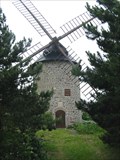 view gallery view galleryNW17.2 km |  Windmill in Gatteville, Barfleur, Normandie, France. Windmill in Gatteville, Barfleur, Normandie, France.
in Windmills Windmill in Gatteville, Barfleur, Normandie, France. This is the private mill of M. Leblanc who restaurated it. posted by: Barjon location: France date approved: 06/25/2007 last visited: 01/30/2023 |
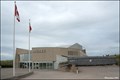
 view gallery view gallery S17.4 km S17.4 km
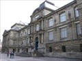
|  Musée des Beaux - Rouen, France Musée des Beaux - Rouen, France
in Art Museums [FR] Le musée des Beaux-Arts abrite l'une des plus prestigieuses collections publiques de France. [EN] An outstanding collection of paintings, drawings and sculptures is complemented by furniture and other art objects. posted by: RakeInTheCache location: Normandie, France date approved: 08/07/2009 last visited: never |
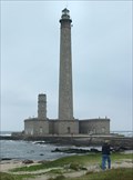
 view gallery view galleryNW17.9 km | Phare de Gatteville, France in Monuments Historiques Français the classified lighthouse is the small one.
le phare classé est le petit. posted by: sara et gege location: Normandie, France date approved: 11/02/2020 last visited: 07/23/2021 |
 view gallery view galleryNW17.9 km | ") le semaphore de Barfleur - Gatteville, France le semaphore de Barfleur - Gatteville, France
in Histoires de France (French historical markers) the semaphore is located behind the great Barfleur lighthouse.
le sémaphore est situé derriere le grand phare de Barfleur. posted by: sara et gege location: Normandie, France date approved: 11/02/2020 last visited: 07/23/2021 |
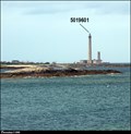 view gallery view galleryNW17.9 km | Point géodésique 5019601 - Phare de Gatteville (Gatteville-le-Phare) in French Benchmarks Point géodésique - sommet du phare (Phare de Gatteville). Geodetical point (GATTEVILLE-LE-PHARE I, 5019601) on the top of the Gatteville lighthouse in Gatteville-le-Phare (Normandy). posted by: Dorcadion Team location: Normandie, France date approved: 06/16/2014 last visited: 03/15/2021 |
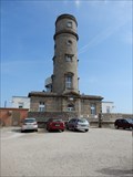
 view gallery view galleryNW17.9 km |  Phare de Gatteville (Normandy) Phare de Gatteville (Normandy)
in Wikipedia Entries Phare de Gatteville, also known as Pointe de Barfleur Light, is an active lighthouse near Gatteville-le-Phare at the tip of Barfleur, Manche department, in the Lower Normandy region of France. posted by: Dorcadion Team location: Normandie, France date approved: 06/16/2014 last visited: 03/15/2021 |
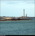
 view gallery view galleryNW17.9 km |  Phare de Gatteville, Normandie, France. Phare de Gatteville, Normandie, France.
in Coastal Lighthouses Phare de Gatteville, Normandie, France. posted by: Barjon location: France date approved: 06/25/2007 last visited: 01/30/2023 |
 view gallery view galleryS21.9 km |  1th US Engineer Special Brigade Monument at Utah Beach (Normandy, France) 1th US Engineer Special Brigade Monument at Utah Beach (Normandy, France)
in World War II Memorials / Monuments The monument dedicated to fallen men of 1th US Engineer Special Brigade you can find in La La Madeleine, where is located one of four main D-Day invasion beaches - Utah... posted by: Dorcadion Team location: Normandie, France date approved: 06/11/2009 last visited: 11/03/2022 |
 view gallery view galleryS21.9 km | Utah Beach - Pouppeville France in Wikipedia Entries Utah, commonly known as Utah Beach, was the code name for one of the five sectors of the Allied invasion of German-occupied France in the Normandy landings on June 6, 1944 (D-Day), during World War II. posted by:  Don.Morfe Don.Morfe location: Normandie, France date approved: 07/30/2022 last visited: 07/31/2022 |
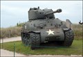 view gallery view galleryS21.9 km |  US Sherman M4 Tank at Utah Beach Museum in La Madeleine (Normandy, France) US Sherman M4 Tank at Utah Beach Museum in La Madeleine (Normandy, France)
in Military Ground Equipment Displays This well preseved American Sherman M4 Tank you can find next to the D-Day Utah Beach Museum in La Madeleine (Calvados-Normandy). posted by: Dorcadion Team location: Normandie, France date approved: 06/15/2009 last visited: 11/03/2022 |
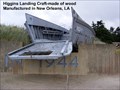
 view gallery view galleryS21.9 km |  Utah Beach Landing Museum / Musée du Débarquement in La Madeleine (Normandy, France) Utah Beach Landing Museum / Musée du Débarquement in La Madeleine (Normandy, France)
in War and Military Museums Facing the one of four main D-Day invasion beaches, Utah, this Museum displays interesting information, weapons and another objects of the D-day landings in this part of Invasion coastal line... posted by: Dorcadion Team location: Normandie, France date approved: 06/14/2009 last visited: 11/03/2022 |
 view gallery view galleryS22 km | 90th Infantry Division-Utah Beach Memorial - Sainte-Marie-du-Mont, Normandie, France in World War II Memorials / Monuments Utah Beach Memorial-To the memory of the heroic dead of the 90th Infantry Division U.S. Army 6 June 1944-9 May 1945. posted by: Don.Morfe location: Normandie, France date approved: 07/31/2022 last visited: 11/03/2022 |
 view gallery view galleryS23.2 km |  Normandy's D-day Beaches - Haute Normadie, France Normandy's D-day Beaches - Haute Normadie, France
in 1000 Places to See Before You Die The Normandy landings (codenamed Operation Neptune) were the landing operations on 6 June 1944 (termed D-Day) of the Allied invasion of Normandy in Operation Overlord during World War II. posted by: ToRo61 location: Normandie, France date approved: 08/13/2014 last visited: 06/22/2022 |
 view gallery view galleryS23.2 km |  Rangers Lead the Way - Pointe-du-Hoc, France Rangers Lead the Way - Pointe-du-Hoc, France
in There's a Book About It The book 'Rangers Lead the Way – Pointe-du-Hoc D-Day 1944' describes a
legendary raid of the US Army 2nd Rangers Battalion during World War II. posted by: ToRo61 location: Normandie, France date approved: 12/14/2014 last visited: 06/22/2022 |
|