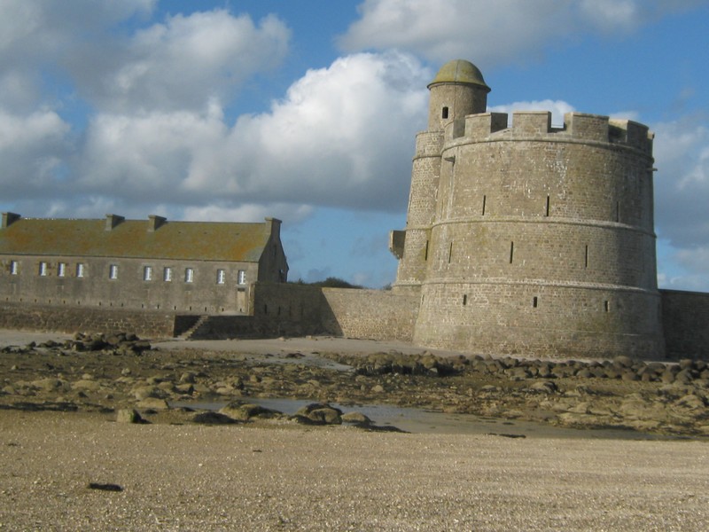
Fort de Tatihou,Saint-Vaast-la-Hougue,France
Posted by: Groundspeak Premium Member celene37
N 49° 35.199 W 001° 14.489
30U E 627101 N 5494159
Le fort de Tatihou à Saint-Vaast-la-Hougue./ Fort Tatihou in Saint-Vaast-la-Hougue.
Waymark Code: WMXT8R
Location: Centre-Val-de-Loire, France
Date Posted: 02/23/2018
Published By:Groundspeak Premium Member pmaupin
Views: 5

Tatihou

Fr:L'île Tatihou est située dans la rade de Saint-Vaast-la-Hougue (département de la Manche). La bataille des 2-3 juin 1692 montre la nécessité de défendre la baie. On décide alors de construire les tours et forts de Tatihou et la Hougue.
En 1694, la tour de Tatihou et sa jumelle la Hougue sont construites par un élève de Vauban, Benjamin de Combes (Il participa ou dirigea la construction de nombreux forts français sous le règne de Louis XIV.) afin de défendre la baie de Saint-Vaast contre les agresseurs.
Elle a 21 mètres de haut, 20 m de diamètre à la base et comporte sur les trois niveaux: un magasin à poudre, un logement pour 80 hommes et une plate-forme pour 10 pièces de canons. Cette tour est entourée d’une ferme fortifiée, comportant casernements et chapelle.
Ces tours sont inscrites, avec treize autres sites fortifiés par Vauban, au patrimoine mondial de l'humanité le 7 juillet 2008.

En:Tatihou Island is located in the bay of Saint-Vaast-la-Hougue (department of Manche). The battle of June 2-3, 1692 shows the need to defend the bay. We decided to build the towers and forts of Tatihou and La Hougue.
In 1694, the tower of Tatihou and his twin La Hougue are built by a pupil of Vauban, Benjamin de Combes (He participated or directed the construction of many French forts during the reign of Louis XIV.) To defend the Bay of St. Vaast against the aggressors.
It is 21 meters high, 20 meters in diameter at the base and has on all three levels: a powder magazine, a housing for 80 men and a platform for 10 pieces of guns. This tower is surrounded by a fortified farm, with barracks and chapel.
These towers are listed, with thirteen other sites fortified by Vauban, World Heritage of Humanity July 7, 2008.

The year the "Fort" was constructed or started.: 1694

Name of "Country" or "Nation" that constructed this "Fort": France

Was this "Fort" involved in any armed conflicts?: I don't know

What was the primary purpose of this "Historic Fort"?: Used for defence of a border or land claim.

Current condition: The restored tower in 1992.All the buildings constituting the fortified farm were highlighted in 2011.

This site is administered by ----: Conseil départemental de la Manche

If admission is charged -: 6.00 (listed in local currency)

Open to the public?: Restricted hours -Admission charged

Official or advertised web-page: [Web Link]

Link to web-site that best describes this "Historic Fort": [Web Link]

Link if this "Fort" is registered on your Countries/ State "Registry of Historical Sites or Buildi: [Web Link]

Visit Instructions:
  • Please post a photo if you visited this "Waymark" and describe your impressions of your visit or anything that might be of use to future visitors or viewers that hasn't been included in this 'Waymark'.
    A "Visited" only will be deleted A.S.A.P.
  • Search for...
    Geocaching.com Google Map
    Google Maps
    MapQuest
    Bing Maps
    Nearest Waymarks
    Nearest Historic Forts
    Nearest Geocaches
    Create a scavenger hunt using this waymark as the center point
    Recent Visits/Logs:
    Date Logged Log User Rating  
    celene37 visited Fort de Tatihou,Saint-Vaast-la-Hougue,France 02/23/2018 celene37 visited it
    junkys visited Fort de Tatihou,Saint-Vaast-la-Hougue,France 05/08/2017 junkys visited it

    View all visits/logs