 view gallery view gallery SE21.2 km SE21.2 km
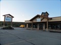
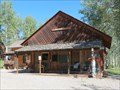
|   ReStore - Silverthorne, CO ReStore - Silverthorne, CO
in Habitat ReStores This ReStore is found in the Summit County area between Dillon, Frisco and Silverthorne. posted by:  Outspoken1 Outspoken1 location: Colorado date approved: 10/08/2013 last visited: never |
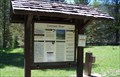
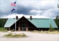 view gallery view gallerySE33.5 km |  Moose visitor Center: Colorado state Forest State Park Moose visitor Center: Colorado state Forest State Park
in Tourist Information Centers - Visitor Centers This visitor center is on highway 14 about a mile east of Gould, Colorado. posted by:  NevaP NevaP location: Colorado date approved: 10/17/2007 last visited: 06/25/2014 |
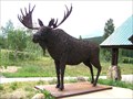 view gallery view gallerySE33.5 km |  Moose- Colorado State Forest Moose- Colorado State Forest
in Figurative Public Sculpture This life sized moose sculpture displays an unusual construction. posted by: NevaP location: Colorado date approved: 10/17/2007 last visited: 06/23/2014 |
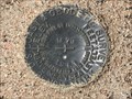 view gallery view gallery NE40.1 km NE40.1 km
|  M 79 (MO0684) - Albany County, Wyoming M 79 (MO0684) - Albany County, Wyoming
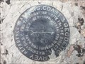
in U.S. Benchmarks This benchmark can be found on the southeast side of State Highway 10. posted by: Tom.dog location: Wyoming date approved: 07/31/2023 last visited: never |
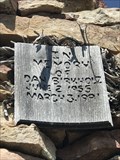 view gallery view galleryNE40.4 km |  Dan Birkholz - Albany County, Wyoming Dan Birkholz - Albany County, Wyoming
in Citizen Memorials This memorial cairn is dedicated to Dan Birkholz, and is located on the western slope of Red Mountain. posted by: Tom.dog location: Wyoming date approved: 07/31/2023 last visited: never |
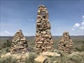 view gallery view galleryNE40.4 km |  Dan Birkholz Cairns - Albany County, Wyoming Dan Birkholz Cairns - Albany County, Wyoming
in Cairns A series of three cairns built in memory of Dan Birkholz, located on the western slope of Red Mountain. posted by: Tom.dog location: Wyoming date approved: 08/04/2023 last visited: never |
 view gallery view galleryNE40.9 km | K 79 (MO0683) - Albany County, Wyoming in U.S. Benchmarks A benchmark on the southeast side of Gyp Quarry Road. posted by: Tom.dog location: Wyoming date approved: 07/31/2023 last visited: never |
 view gallery view gallery E40.9 km E40.9 km
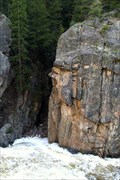
|  Guardian of the Falls Guardian of the Falls
in Simulacra Guardian of the Falls. A profile of a Trojan Warrior keeping guard over the water fall. posted by: CacheKamm location: Colorado date approved: 06/22/2011 last visited: never |
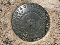
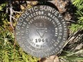 view gallery view galleryNE41.4 km | RED (LL1395) - Larimer County, Colorado in U.S. Benchmarks A triangulation station on the summit of Red Mountain, just south of the Wyoming-Colorado border. posted by: Tom.dog location: Colorado date approved: 07/31/2023 last visited: never |
 view gallery view galleryNE41.4 km | RED NO 1 - Larimer County, Colorado in U.S. Benchmarks Reference mark 1 for triangulation station RED (LL1395). posted by: Tom.dog location: Colorado date approved: 07/31/2023 last visited: never |
 view gallery view gallery SW47.5 km SW47.5 km
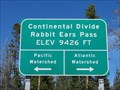
|  Continental Divide, Rabbit Ears Pass at 9,426 ft - Grand County, Colorado Continental Divide, Rabbit Ears Pass at 9,426 ft - Grand County, Colorado
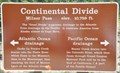
in Elevation Signs The Continental Divide (also called the Great Divide or Continental Divide of the Americas) determines whether water flows to the Pacific or Atlantic Ocean. posted by: Outspoken1 location: Colorado date approved: 09/21/2014 last visited: 06/10/2017 |
 view gallery view gallerySW47.5 km |  Continental Divide, Rabbit Ears Pass - Grand County, Colorado Continental Divide, Rabbit Ears Pass - Grand County, Colorado
in Places of Geologic Significance The Continental Divide (also called the Great Divide or Continental Divide of the Americas) determines whether water flows to the Pacific or Atlantic Ocean. posted by: Outspoken1 location: Colorado date approved: 09/22/2014 last visited: 06/10/2017 |
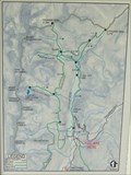 view gallery view gallerySE51.7 km |  You Are Here - Colorado River Trailhead - Rocky Mountains National Park, CO You Are Here - Colorado River Trailhead - Rocky Mountains National Park, CO
in 'You Are Here' Maps The Colorado River Trail is nearly a water level trail, only 350' of elevation gain. The southern end of the trail is at a parking area off US Hwy 34. Beginning elevation is about 9000'. posted by: hummerstation location: Colorado date approved: 07/29/2014 last visited: never |
 view gallery view gallerySE51.7 km |  Colorado River Trailhead - Rocky Mountains National Park, CO Colorado River Trailhead - Rocky Mountains National Park, CO
in Hiking and walking trailheads The Colorado River Trail is the most popular trailhead in the less scenic western half of Rocky Mountain National Park. posted by: hummerstation location: Colorado date approved: 01/01/2015 last visited: never |
 view gallery view gallerySW52.3 km |  OLDEST -- Perry-Mansfield School of Theatre and Dance - Steamboat Springs, CO OLDEST -- Perry-Mansfield School of Theatre and Dance - Steamboat Springs, CO
in Superlatives Established in 1914, the school/camp is the oldest, continuously operating, modern dance camp in the United States. They moved to this secluded location after too many 'peeping-toms' in Denver! posted by: Outspoken1 location: Colorado date approved: 09/22/2014 last visited: never |
 view gallery view gallerySW52.3 km |  Perry-Mansfield School of Theatre and Dance - Steamboat Springs, CO Perry-Mansfield School of Theatre and Dance - Steamboat Springs, CO
in U.S. National Register of Historic Places Established in 1914, the school/camp is the oldest, continuously operating, modern dance camp in the United States. They moved to this secluded location after too many 'peeping-toms' in Denver! posted by: Outspoken1 location: Colorado date approved: 09/22/2014 last visited: never |
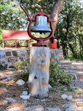 view gallery view gallerySW52.3 km |  Perry-Mansfield School of Theatre and Dance - Steamboat Springs, CO Perry-Mansfield School of Theatre and Dance - Steamboat Springs, CO
in Bells Established in 1914, the school/camp is the oldest, continuously operating, modern dance camp in the United States. They moved to this secluded location after too many 'peeping-toms' in Denver! This bell was to call students to the outdoor theatre. posted by: Outspoken1 location: Colorado date approved: 09/22/2014 last visited: never |
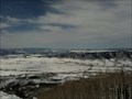 view gallery view gallerySW52.5 km |  Steamboat/Yampa Valley Overlook Steamboat/Yampa Valley Overlook
in Scenic Overlooks Looking out over the Yampa Valley from the Broadway run at Steamboat Springs. posted by:  terribletreads terribletreads location: Colorado date approved: 03/25/2010 last visited: 06/10/2017 |
 view gallery view gallerySE52.6 km | Continental Divide/Milner Pass ~ Elevation 10,759 Feet in Elevation Signs This Elevation is inscribed on the Continental Divide/Milner Pass Sign located on the east side of Trail Ridge Road (US Highway 34) at the summit of Milner Pass. posted by: brwhiz location: Colorado date approved: 02/10/2013 last visited: 09/03/2020 |
 view gallery view gallerySE52.6 km | Milner Pass ~ Elevation 10,750 Feet in Elevation Signs This Elevation Sign inscribed on the Milner Pass Information Sign located on the east side of Trail Ridge Road (US Highway 34) at the summit of Milner Pass. posted by: brwhiz location: Colorado date approved: 02/10/2013 last visited: 10/09/2016 |
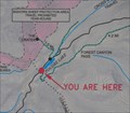 view gallery view gallerySE52.6 km | Milner Pass Summit in 'You Are Here' Maps You Are Here on the southwest end of Poudre Lake at the summit of Milner Pass in Rocky Mountain National Park. posted by: brwhiz location: Colorado date approved: 08/29/2013 last visited: 06/08/2014 |
 view gallery view gallerySE52.6 km | Old Fall River Roadway in Hiking and walking trailheads This Hiking and Walking Trailhead is located at a turnout on the southeast side of US Highway 34 (Trail Ridge Road) at the summit of Milner Pass and the Continental Divide in Rocky Mountain National Park, Colorado. posted by: brwhiz location: Colorado date approved: 03/08/2013 last visited: never |
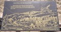
 view gallery view gallerySE52.6 km |  Beaver Trade ~ Rocky Mountain National Park, Colorado Beaver Trade ~ Rocky Mountain National Park, Colorado
in Colorado Historical Markers This Historical Marker is mounted on a steel post at a turnout on the southeast side of US Highway 34 (Trail Ridge Road) at the summit of Milner Pass and the Continental Divide in Rocky Mountain National Park, Colorado. posted by: brwhiz location: Colorado date approved: 02/08/2013 last visited: never |
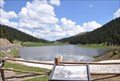 view gallery view gallerySE52.6 km |  Poudre Lake ~ Colorado, USA Poudre Lake ~ Colorado, USA
in Natural Lakes The best place to view this lovely alpine lake is a parking lot on the southeast side of US Highway 34 (Trail Ridge Road) at the summit of Milner Pass and the Continental Divide in Rocky Mountain National Park, Colorado. posted by: brwhiz location: Colorado date approved: 02/07/2013 last visited: 10/09/2016 |
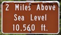 view gallery view gallerySE52.9 km | Trail Ridge Road ~ Two Miles Above Sea Level in Elevation Signs This Elevation Sign is located on the north side of Trail Ridge Road (US Highway 34) about 16.5 miles north of Grand Lake, Colorado. posted by: brwhiz location: Colorado date approved: 02/10/2013 last visited: 07/19/2017 |
|