 view gallery view gallery SE6.9 km SE6.9 km
|   Noble Emigrant Trail Noble Emigrant Trail
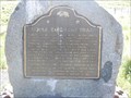
in California Historical Markers Historic Marker along US395 posted by:  CA Boilermaker CA Boilermaker location: California date approved: 05/27/2008 last visited: 05/26/2014 |
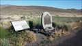 view gallery view gallerySE6.9 km |  Noble Emigrant Trail - Lassen County, CA Noble Emigrant Trail - Lassen County, CA
in Wagon Roads and Trails This official California Historical Marker notes the passage of the Noble Emigrant Trail through this point in 1852. posted by: NW_history_buff location: California date approved: 09/19/2014 last visited: never |
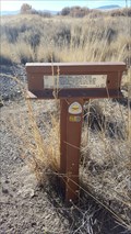
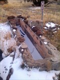
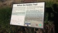 view gallery view gallerySE6.9 km |  Before the Nobles Trail - Lassen County, CA Before the Nobles Trail - Lassen County, CA
in Signs of History This historical placard and official California Historical Marker note the passage of the Noble Emigrant Trail through this point in 1852. posted by: NW_history_buff location: California date approved: 09/19/2014 last visited: never |
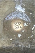
 view gallery view gallery S7.6 km S7.6 km
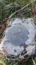
|  USGS '40JD 4068' BM - Litchfield, CA USGS '40JD 4068' BM - Litchfield, CA
in U.S. Benchmarks This benchmark resides at the corner of Center Rd and Blue Lane. posted by: NW_history_buff location: California date approved: 11/15/2016 last visited: never |
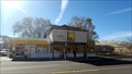
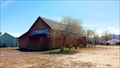
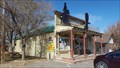 view gallery view galleryS7.6 km |  Heard's Market - Litchfield, CA Heard's Market - Litchfield, CA
in The Local Neighborhood Grocer A family-owned market in the community of Litchfield. posted by: NW_history_buff location: California date approved: 12/22/2016 last visited: never |
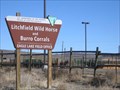 view gallery view gallerySE8 km |  Litchfield Wild Horse and Burro Corrals (BLM) - Litchfield, CA Litchfield Wild Horse and Burro Corrals (BLM) - Litchfield, CA
in Humane Societies and Rescues The ultimate rescue operation ... where the wild horses and burros go.... before they are adopted posted by:  fishingwishing fishingwishing location: California date approved: 06/12/2008 last visited: 04/27/2012 |
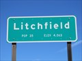 view gallery view galleryS8 km |  Litchfield, CA - 4063' Litchfield, CA - 4063'
in Elevation Signs The sign is located at the western entrance to Litchfield on Highway 395. posted by: WR7X location: California date approved: 03/21/2014 last visited: never |
 view gallery view galleryS8.2 km | Nobles Trail - Soldiers Bridge in Signs of History This historical 'T' marker is located just south of Hwy 395 and if you're not paying attention, you will miss this marker located between Standish and Litchfield. posted by: NW_history_buff location: California date approved: 01/02/2017 last visited: never |
 view gallery view gallery SW10.5 km SW10.5 km
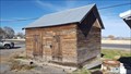
|  Old Standish Jail - Standish, CA Old Standish Jail - Standish, CA
in Retired Prisons This former jail was discovered after grabbing a nearby geocache. posted by: NW_history_buff location: California date approved: 12/05/2016 last visited: never |
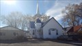 view gallery view gallerySW10.6 km |  Standish Bible Church - Standish, CA Standish Bible Church - Standish, CA
in Religious Buildings Multifarious This small church is located in the quiet community of Standish. posted by: NW_history_buff location: Oregon date approved: 12/31/2016 last visited: never |
 view gallery view gallerySW10.6 km | Wayside Inn Mini Mart - Standish, CA in The Local Neighborhood Grocer The Wayside Inn looks to have been much than a mini mart back in the day. posted by: NW_history_buff location: California date approved: 12/22/2016 last visited: never |
 view gallery view gallery W17.5 km W17.5 km
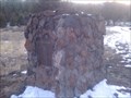
|  Jacks Valley, CA Jacks Valley, CA
in E Clampus Vitus Historical Markers This E Clampus Vitus historical marker sits just off Hwy 139 in Lassen County, CA. posted by: NW_history_buff location: California date approved: 12/27/2013 last visited: never |
 view gallery view galleryW17.5 km |  Jacks Valley Water Trough - Lassen County, CA Jacks Valley Water Trough - Lassen County, CA
in Historic Upping Stones, Hitching Posts, and Carriage Blocks This E Clampus Vitus historical marker sits just off Hwy 139 in Lassen County, CA and claims the nearby watering trough as the only one of its kind in northeastern California. posted by: NW_history_buff location: California date approved: 07/07/2014 last visited: never |
 view gallery view galleryW17.5 km |  ONLY -- Water Trough of its Kind in Northeastern California ONLY -- Water Trough of its Kind in Northeastern California
in Superlatives This E Clampus Vitus historical marker sits just off Hwy 139 in Lassen County, CA and claims the nearby watering trough as the only one of its kind in northeastern California. posted by: NW_history_buff location: California date approved: 12/27/2013 last visited: never |
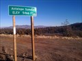 view gallery view galleryW18 km | Antelope Summit - Elev 5466 ft - Lassen County, CA in Elevation Signs Travelers along Hwy 139 and just north of Susanville, will pass Antelope Summit located within Lassen County, CA. posted by: NW_history_buff location: California date approved: 01/17/2014 last visited: never |
 view gallery view gallerySW20 km |  Bass Hill Kinetic Airplane - Susanville, CA Bass Hill Kinetic Airplane - Susanville, CA
in Kinetic Sculpture and Art A Kinetic Airplane at the Bass Hill Landfill near Susanville, CA posted by: find waldo location: California date approved: 04/19/2014 last visited: never |
 view gallery view gallerySW20 km |  Bass Hill Airplane - Susanville, CA Bass Hill Airplane - Susanville, CA
in Realistic Object Sculptures a Kinetic Airplane made of metal parts. posted by: find waldo location: California date approved: 04/18/2014 last visited: never |
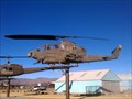 view gallery view gallerySW20.4 km |  Bell AH-1F Cobra Helicopter - Susanville, CA Bell AH-1F Cobra Helicopter - Susanville, CA
in Static Aircraft Displays This military helicopter is located at the entrance to the City of Susanville Airport. posted by: NW_history_buff location: California date approved: 01/13/2014 last visited: 04/17/2014 |
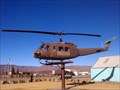 view gallery view gallerySW20.4 km | Bell UH-1H Iroquois 'Huey' Helicopter - Susanville, CA in Static Aircraft Displays This military helicopter is is located at the entrance to the City of Susanville Airport. posted by: NW_history_buff location: California date approved: 01/13/2014 last visited: 04/17/2014 |
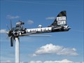
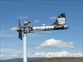
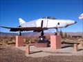
 view gallery view gallerySW20.4 km | F-4 Phantom Fighter Jet - Susanville, CA in Static Aircraft Displays This former fighter jet is located at the entrance to the City of Susanville Airport. posted by: NW_history_buff location: California date approved: 01/11/2014 last visited: 04/17/2014 |
 view gallery view gallerySW20.4 km |  City of Susanville Airport Veterans Monument - Susanville, CA City of Susanville Airport Veterans Monument - Susanville, CA
in Rotary International Markers This military aircraft static display and monument are located at the entrance to the City of Susanville Airport just south of Susanville, CA. posted by: NW_history_buff location: California date approved: 01/12/2014 last visited: 04/17/2014 |
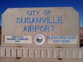 view gallery view gallerySW20.4 km | City of Susanville Airport - Elevation 4148 in Elevation Signs This elevation designation is listed on the the City of Susanville Airport entrance sign just south of Susanville, CA. posted by: NW_history_buff location: California date approved: 01/11/2014 last visited: 04/17/2014 |
 view gallery view galleryW20.4 km | LT0133 - USCGS 'Z 140' BM - Susanville, CA in U.S. Benchmarks This NGS benchmark resides at a bridge crossing along Johnstonville Rd. posted by: NW_history_buff location: California date approved: 04/30/2015 last visited: never |
 view gallery view galleryW20.8 km |  Honey Lake Valley Grange No. 825 - Johnstonville, CA Honey Lake Valley Grange No. 825 - Johnstonville, CA
in Grange Halls This historic grange has its history going back to the late 1880s as mentioned by the Grange Master. posted by: NW_history_buff location: California date approved: 06/03/2015 last visited: never |
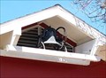 view gallery view galleryW20.8 km |  Johnstonville Elementary School Bell - Johnstonville, CA Johnstonville Elementary School Bell - Johnstonville, CA
in Bells This old school bell is located under and eave to the current Johnstonville Elementary School. posted by: NW_history_buff location: California date approved: 05/06/2015 last visited: never |
|