 view gallery view gallery N11.9 km N11.9 km
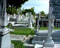
|   Panteon Antiguo, Matamoros, Tamaulipas, Mexico Panteon Antiguo, Matamoros, Tamaulipas, Mexico
in Worldwide Cemeteries Over 7,000 tombstones crowd Matamoros’s oldest cemetery, most in beautifully detailed above-ground crypts. posted by:  JimmyEv JimmyEv location: Mexico date approved: 03/16/2008 last visited: never |
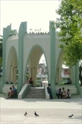 view gallery view galleryN12.2 km |  Plaza Allende, Matmoros, Mexico Plaza Allende, Matmoros, Mexico
in Municipal Parks and Plazas This shady plaza, with its modern gazebo, is busy - very busy - filled with both people and vendors. Typical of Mexico, the plaza is fronted by a Catholic church. posted by: JimmyEv location: Mexico date approved: 02/08/2008 last visited: never |
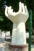 view gallery view galleryN12.4 km | Plaza Mutualista, Matamoros, Mexico in Municipal Parks and Plazas This shady plaza, in the center of the street, contains a large surrealistic sculpture of hands turning into a dove. There’s also a dry fountain. posted by: JimmyEv location: Mexico date approved: 02/08/2008 last visited: never |
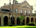
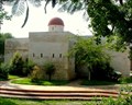 view gallery view galleryN12.4 km |  Museo Casamata, Matamoros, Mexico Museo Casamata, Matamoros, Mexico
in History Museums Within the walls of the Casamata, a refuge during the many turbulent times in Matamoros, unfolds the history of both Matamoros and the state of Tamaulipas, intricately wound with the United States. posted by: JimmyEv location: Tamaulipas, Mexico date approved: 03/08/2008 last visited: never |
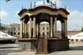 view gallery view galleryN12.4 km | Plaza Hidalgo, Matamoros, Mexico in Municipal Parks and Plazas This typical Mexican town square, fronted by Matamoros’ City Hall and Cathedral, is the center of the city. There’s a statue of Padre Miguel Hidalgo and a gazebo with a gorgeously painted ceiling. posted by: JimmyEv location: Mexico date approved: 02/08/2008 last visited: never |
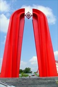 view gallery view galleryN13 km |  La Gran Puerta de Mexico, Matamoros, Mexico La Gran Puerta de Mexico, Matamoros, Mexico
in Abstract Public Sculptures This huge red 'M,' designed by Sebastian, represents Matamoros, the 'Great Gate of Mexico.' posted by: JimmyEv location: Mexico date approved: 11/08/2007 last visited: never |
 view gallery view galleryN13 km | Olympic Recreational and Cultural Complex, Matamoros, Mexico in Municipal Parks and Plazas The Alameda, or ‘Park,’ is part of Matamoros’ Olympic Park. A few blocks from the International Bridge, it is home to the city’s library, an arena, and the ‘Gateway to Mexico’ arch. posted by: JimmyEv location: Mexico date approved: 02/08/2008 last visited: never |
 view gallery view galleryN13.7 km |  Brownsville & Matamoros International Bridge Brownsville & Matamoros International Bridge
in Border Crossings Three bridges link Brownsville with Matamoros across the Rio Grande. This bridge is closest to central Matamoros. posted by: JimmyEv location: Texas date approved: 12/29/2007 last visited: never |
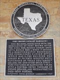
 view gallery view galleryN13.8 km |  Fort Brown, Texas Fort Brown, Texas
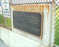
in Texas Historical Markers This Texas Historical Marker is 130 feet west of the Clubhouse of the Fort Brown Memorial Golf Course on 300 River Levee Road in Brownsville, Texas. posted by:  PeterNoG PeterNoG location: Texas date approved: 01/08/2014 last visited: 01/12/2014 |
 view gallery view gallery NE14.2 km NE14.2 km
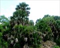
|  Sabal Palm Sanctuary - Brownsville, Texas Sabal Palm Sanctuary - Brownsville, Texas
in Official Local Tourism Attractions This park preserves one of the few remaining tracts of native Sabal Palm Forest. It’s great for birding - you'll probably see a Green Jay - and hiking too. posted by: JimmyEv location: Texas date approved: 03/20/2008 last visited: 03/07/2018 |
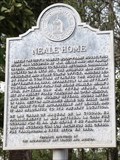 view gallery view galleryN14.2 km |  Neale Home - Brownsville TX Neale Home - Brownsville TX
in Signs of History This Sign of History is in front of the Neale House on Neale Drive just north of Ringgold Road in Fort Brown (now Texas Southmost College) in Brownsville, Texas. posted by: PeterNoG location: Texas date approved: 01/26/2014 last visited: 12/20/2013 |
 view gallery view galleryN14.2 km | Neale House in Texas Historical Markers This Texas Historical Marker is on the Neale House on Neale Drive just north of Ringgold Road in Fort Brown (now Texas Southmost College) in Brownsville, Texas. posted by: PeterNoG location: Texas date approved: 01/10/2014 last visited: 01/12/2014 |
 view gallery view galleryN14.2 km |  Neale House - Brownsville TX Neale House - Brownsville TX
in Relocated Structures This Relocated Structure is the Neale House which is now on Neale Drive just north of Ringgold Road in Fort Brown (now Texas Southmost College) in Brownsville, Texas. posted by: PeterNoG location: Texas date approved: 04/09/2014 last visited: 01/18/2015 |
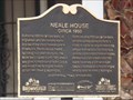 view gallery view galleryN14.2 km | Neale House circa 1850 - Brownsville TX in Signs of History This is another Sign of History that is in front of the Neale House on Neale Drive just north of Ringgold Road in Fort Brown (now Texas Southmost College) in Brownsville, Texas. posted by: PeterNoG location: Texas date approved: 04/08/2014 last visited: 12/20/2013 |
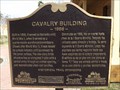 view gallery view galleryN14.5 km | Cavalry Building - Brownsville TX in Signs of History This Sign of History is at the southwest corner of the Cavalry Building on Gorgas Drive at Ringgold Road in Fort Brown (now Texas Southmost College) in Brownsville, Texas. posted by: PeterNoG location: Texas date approved: 01/13/2014 last visited: 07/17/2015 |
 view gallery view galleryN14.6 km | Fort Brown Cavalry Barracks in Texas Historical Markers This Texas Historical Marker is on the northwest side of the Cavalry Barracks on Gorgas Drive at Ringgold Road in Fort Brown (now Texas Southmost College) in Brownsville, Texas. posted by: PeterNoG location: Texas date approved: 01/11/2014 last visited: 07/17/2015 |
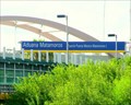 view gallery view galleryN14.6 km | Gateway International Bridge, Matamoros-Brownsville in Border Crossings Three bridges link Brownsville with Matamoros across the Rio Grande. This bridge empties directly into downtown Brownsville, where parking is plentiful, and is the main pedestrian crossing. posted by: JimmyEv location: Texas date approved: 12/29/2007 last visited: 07/17/2015 |
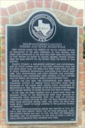 view gallery view galleryN14.6 km | Brownsville-Matamoros Ferries and River Boardwalk in Texas Historical Markers A boardwalk along the Rio Grande, lined with shops, once linked the ferries connecting Brownsville with Matamoros. The boardwalk and shops vanished with the ferries. posted by: JimmyEv location: Texas date approved: 11/13/2007 last visited: 01/04/2014 |
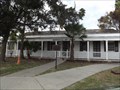
 view gallery view galleryN14.6 km |  Fort Brown - Brownsville, Texas Fort Brown - Brownsville, Texas
in U.S. National Register of Historic Places Fort Brown was instrumental in precipitating the Mexican War. The fort also played a role in the Civil War, the Spanish-American War, and protected Brownsville from bandit raids at the turn-of-the century. posted by: JimmyEv location: Texas date approved: 03/11/2008 last visited: 07/17/2015 |
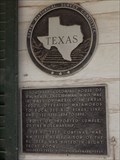
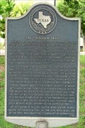 view gallery view galleryN14.6 km | Chisholm Trail in Texas Historical Markers This marks the southernmost point of the network of trails that became known as the Chisholm Trail. posted by: JimmyEv location: Texas date approved: 11/12/2007 last visited: 01/04/2014 |
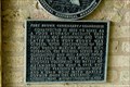 view gallery view galleryN14.6 km | Fort Brown Commissary/Guardhouse in Texas Historical Markers Built a year before the closing of the fort, this building served as a commissary. When the fort was re-activated due to Mexican border disturbances, the building served as the guardhouse and jail. posted by: JimmyEv location: Texas date approved: 11/13/2007 last visited: 07/17/2015 |
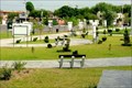
 view gallery view galleryN14.6 km | Alice Wilson Hope Park, Brownsville, Texas in Municipal Parks and Plazas Adjacent to the International Bridge, this small park gives good views of the Rio Grande and holds a marker for the beginning of the Chisholm Trail, the 1000-mile cattle drive terminating in Abilene, Kansas. posted by: JimmyEv location: Texas date approved: 12/30/2007 last visited: 01/09/2014 |
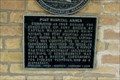 view gallery view galleryN14.6 km | Post Hospital Annex in Texas Historical Markers The Annex housed personnel working in the Post Hospital. posted by: JimmyEv location: Texas date approved: 11/13/2007 last visited: 07/17/2015 |
 view gallery view galleryN14.6 km |  Parks and Recreation Flag - Brownsville TX Parks and Recreation Flag - Brownsville TX
in Flags of Organizations This Flags of an Organization is in Alice Wilson Hope Park on the corner of Sam Perl Boulevard and East St Charles Street in Brownsville, Texas. posted by: PeterNoG location: Texas date approved: 05/03/2014 last visited: 01/04/2014 |
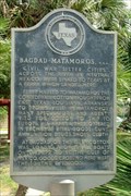 view gallery view galleryN14.6 km | Bagdad-Matamoros, C.S.A. in Texas Historical Markers With the Federal blockade on Southern ports, the port of Bagdad in Mexico became an important outlet for Southern cotton. posted by: JimmyEv location: Texas date approved: 11/21/2007 last visited: 07/17/2015 |
|