 view gallery view gallery E4.7 km E4.7 km
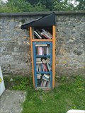
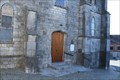
|   Boite à livre -Beaumont, Belgique Boite à livre -Beaumont, Belgique
in Free Community Book Exchanges EN - A box reading where each of us the opportunity to drop off a book. FR - Une boîte de lecture où chacun de nous a la possibilité de déposer un livre.
NL - Een lectuurbak waar ieder van ons een boek in kan doen. posted by:  geotrouvtou59 geotrouvtou59 location: Hainaut, Belgium date approved: 08/10/2021 last visited: 08/12/2021 |
 view gallery view gallery N6.4 km N6.4 km
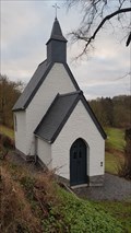
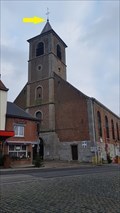
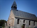
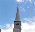
|  Chapelle Saint-Julien - Beaumont - Belgique Chapelle Saint-Julien - Beaumont - Belgique
in Wikipedia Entries [FR] Édifice religieux catholique construite hors de l’enceinte de la ville. [EN] Catholic religious building built outside the city walls. posted by: PaulLassiter location: Hainaut, Belgium date approved: 03/01/2020 last visited: 06/02/2022 |
 view gallery view galleryN6.4 km |  Chapelle Saint-Julien - Beaumont - Belgique Chapelle Saint-Julien - Beaumont - Belgique
in Belgium Monument Registers [FR] Édifice religieux catholique construite hors de l’enceinte de la ville. [EN] Catholic religious building built outside the city walls. posted by: PaulLassiter location: Hainaut, Belgium date approved: 03/01/2020 last visited: 06/02/2022 |
 view gallery view galleryN6.6 km | Les remparts de la ville - Beaumont - Belgique in Belgium Monument Registers [FR] Ancienne enceinte de 2 500 mètres environ composée d’une nombreuses tours, mailles, trois portes et une poterne. [EN] A former enclosure of about 2,500 metres consisting of a number of towers, meshes, three gates and a postern. posted by: PaulLassiter location: Hainaut, Belgium date approved: 09/24/2021 last visited: never |
 view gallery view galleryN6.6 km |  Sambre Rouge : La vallée de la Hantes - Beaumont - Belgique Sambre Rouge : La vallée de la Hantes - Beaumont - Belgique
in Signs of History [FR] Les corps d'armée françaises ont bivouaqué dans la vallée, en bas de la ville. [EN] The French army corps bivouacked in the valley below the town. posted by: PaulLassiter location: Hainaut, Belgium date approved: 01/24/2021 last visited: never |
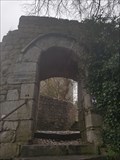
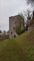 view gallery view galleryN6.6 km | Tour Salamandre - Beaumont - Belgique in Wikipedia Entries [FR] Ancien donjon du XIe siècle développé et agrandi en forteresse qui est à l’origine de la ville de Beaumont. [EN] An old 11th century keep developed and enlarged into a fortress which is at the origin of the town of Beaumont. posted by: PaulLassiter location: Hainaut, Belgium date approved: 02/27/2020 last visited: 06/02/2022 |
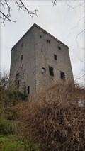 view gallery view galleryN6.6 km | Tour Salamandre - Beaumont - Belgique in Belgium Monument Registers FR] Ancien donjon du XIe siècle développé et agrandi en forteresse qui est à l’origine de la ville de Beaumont. [EN] An old 11th century keep developed and enlarged into a fortress which is at the origin of the town of Beaumont. posted by: PaulLassiter location: Hainaut, Belgium date approved: 02/28/2020 last visited: 06/02/2022 |
 view gallery view galleryN6.9 km | Sambre Rouge : Passage obligé vers l'ennemi - Beaumont - Belgique in Signs of History [FR] Les corps d'armée françaises ont bivouaqué dans la vallée, en bas de la ville. [EN] The French army corps bivouacked in the valley below the town. posted by: PaulLassiter location: Hainaut, Belgium date approved: 03/03/2020 last visited: never |
 view gallery view galleryN6.9 km |  Monument aux Habitants et au Roi - Beaumont - Belgique Monument aux Habitants et au Roi - Beaumont - Belgique
in World War I Memorials and Monuments [FR] Monument communal en pierre bleue honorant les habitants de Beaumont et le roi. [EN] Communal monument in blue stone honouring the inhabitants of Beaumont and the king. posted by: PaulLassiter location: Hainaut, Belgium date approved: 03/13/2020 last visited: never |
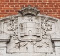 view gallery view galleryN6.9 km |  Blason de la ville - Beaumont - Namur Blason de la ville - Beaumont - Namur
in Coats of Arms [FR] Armoiries de la ville gravé au sommet du Monument des guerres mondiales. [EN] Coat of arms of the city engraved on top of the World War Monument. posted by: PaulLassiter location: Hainaut, Belgium date approved: 03/06/2020 last visited: never |
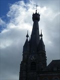
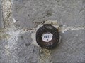
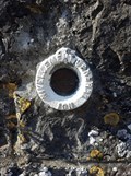
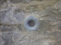
 view gallery view galleryN6.9 km |  NGI Point Planimétrique 52F50C1 - Beaumont - Belgique NGI Point Planimétrique 52F50C1 - Beaumont - Belgique
in Belgium Benchmarks Rue de l'église, église Saint-Servais, pied de la croix posted by: PaulLassiter location: Hainaut, Belgium date approved: 02/10/2021 last visited: 06/02/2022 |
 view gallery view gallery W8 km W8 km
|  Benchmark SOLRE-LE-CHATEAU II Benchmark SOLRE-LE-CHATEAU II
in French Benchmarks Benchmark du Nord posted by: geotrouvtou59 location: Hauts-de-France, France date approved: 08/01/2013 last visited: 07/31/2013 |
 view gallery view galleryW8 km | Benchmark Eglise DE SOLRE-LE-CHATEAU in French Benchmarks Benchmark du Nord posted by: geotrouvtou59 location: Hauts-de-France, France date approved: 08/01/2013 last visited: 07/31/2013 |
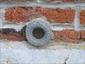
 view gallery view galleryW8.4 km | Chapelle Notre-Dame-de-Walcourt - Solre-le-Château, France in French Benchmarks Repère Cylindrique du Nivellement Général sur la Chapelle Notre-Dame-de-Walcourt. posted by: OliLesp location: Hauts-de-France, France date approved: 10/09/2019 last visited: never |
 view gallery view galleryW9.8 km | Benchmark Eglise de SOLRINNES in French Benchmarks Benchmark du Nord posted by: geotrouvtou59 location: Hauts-de-France, France date approved: 07/31/2013 last visited: 07/31/2013 |
 view gallery view gallery SW10.9 km SW10.9 km
|  Eglise Saint-Lambert - Liessies, France Eglise Saint-Lambert - Liessies, France
in Monuments Historiques Français FR - L'abbaye de Liessies est une abbaye bénédictine.
EN - Liessies Abbey is a Benedictine abbey. posted by: geotrouvtou59 location: Hauts-de-France, France date approved: 04/17/2021 last visited: 04/17/2021 |
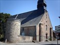 view gallery view gallerySW10.9 km |  Eglise Saint-Lambert - Liessies, France Eglise Saint-Lambert - Liessies, France
in Roman Catholic Churches FR - L’église Saint-Jean remonte au XVI e siècle.
EN - The Saint-Jean church dates back to the 16th century. posted by: geotrouvtou59 location: Hauts-de-France, France date approved: 04/17/2021 last visited: 04/17/2008 |
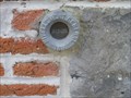
 view gallery view galleryE11.4 km | ING point de Mesure: Og13 - Eglise Sainte-Marie-Madeleine - Erpion in Belgium Benchmarks ING point de Mesure: Og13 sur l'Eglise Sainte-Marie-Madeleine à Erpion. posted by: pmaupin location: Hainaut, Belgium date approved: 06/03/2022 last visited: 06/09/2022 |
 view gallery view galleryW11.9 km | Benchmark clocher église de DIMECHAUX A in French Benchmarks Benchmark du Nord posted by: geotrouvtou59 location: Hauts-de-France, France date approved: 08/01/2013 last visited: 07/31/2013 |
 view gallery view galleryW11.9 km | Benchmark Maison à DIMECHAUX in French Benchmarks Benchmark du Nord posted by: geotrouvtou59 location: Hauts-de-France, France date approved: 07/29/2013 last visited: 07/29/2013 |
 view gallery view galleryW11.9 km | Benchmark Eglise de DIMECHAUX in French Benchmarks Benchmark du Nord posted by: geotrouvtou59 location: Hauts-de-France, France date approved: 08/01/2013 last visited: 07/31/2013 |
 view gallery view gallery NE11.9 km NE11.9 km
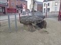
|  La Pierre du Diable - Clermont - Belgique La Pierre du Diable - Clermont - Belgique
in Megalithic Monuments [FR] Ancien dolmen qui était situé sur le Mont de Viscourt. [EN] Old dolmen which was located on the Mont de Viscourt. posted by: PaulLassiter location: Namur, Belgium date approved: 02/06/2021 last visited: never |
 view gallery view galleryNE11.9 km | Dolmen du Mont de Viscourt - Clermont - Belgique in Wikipedia Entries [FR] Ancien dolmen qui était situé sur le Mont de Viscourt. [EN] Old dolmen which was located on the Mont de Viscourt. posted by: PaulLassiter location: Namur, Belgium date approved: 02/05/2021 last visited: never |
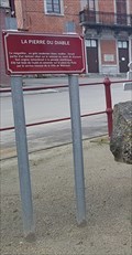 view gallery view galleryNE11.9 km |  La Pierre du Diable - Clermont - Belgique La Pierre du Diable - Clermont - Belgique
in Geological Devilish Locations [FR] Ancien dolmen qui était situé sur le Mont de Viscourt. [EN] Old dolmen which was located on the Mont de Viscourt. posted by: PaulLassiter location: Namur, Belgium date approved: 02/12/2021 last visited: never |
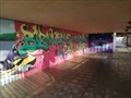 view gallery view galleryE12.7 km |  Bienvenue au pays des lacs - Froidchapelle - Belgique Bienvenue au pays des lacs - Froidchapelle - Belgique
in Graffiti [FR] Inscription Multicolore de bienvenue situé dans le tunnel en dessous du centre d'accueil de la Plate Taille. [EN] Multicoloured welcome sign located in the tunnel below the Plate Taille Visitor Centre. posted by: PaulLassiter location: Hainaut, Belgium date approved: 02/06/2020 last visited: never |
|