 view gallery view gallery S19.3 km S19.3 km
|   Spring Prairie Township, Minnesota Spring Prairie Township, Minnesota
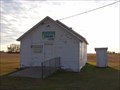
in City and Town Halls Town hall for Spring Prairie Township, Clay County. posted by:  msrubble msrubble location: Minnesota date approved: 02/12/2013 last visited: never |
 view gallery view gallery SW19.6 km SW19.6 km
|  Valley R/C Flyers Home Field - Kragnes, MN Valley R/C Flyers Home Field - Kragnes, MN
in Model Aircraft Fields The field is located two miles east of Krangess, MN on Clay County 5. posted by: m&m O location: Minnesota date approved: 08/07/2019 last visited: never |
 view gallery view gallerySW20.9 km |  Township Meeting Hall - Moland Township, MN Township Meeting Hall - Moland Township, MN
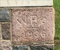
in Dated Buildings and Cornerstones This corner stone was laid when this building was first built as a school. posted by: m&m O location: Minnesota date approved: 07/28/2020 last visited: never |
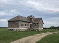
 view gallery view gallerySW20.9 km |  Moland Township Meeting Hall - Moland, MN Moland Township Meeting Hall - Moland, MN
in WPA Projects Old country school now used as a township meeting hall. posted by: m&m O location: Minnesota date approved: 07/28/2020 last visited: never |
 view gallery view gallerySW20.9 km |  “Gunderson School" Dilworth, MN “Gunderson School" Dilworth, MN
in One-Room Schoolhouses 3739 70th St N, Glyndon, MN 56547 posted by: m&m O location: Minnesota date approved: 01/09/2020 last visited: never |
 view gallery view gallerySW20.9 km |  Former Township Schoolhouse - Moland Township, MN Former Township Schoolhouse - Moland Township, MN
in Former Schools This former school house is now a township meeting location. posted by: m&m O location: Minnesota date approved: 07/23/2020 last visited: never |
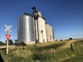 view gallery view gallerySW21.1 km |  Kragnes Farmers Elevator - Kragnes, MN Kragnes Farmers Elevator - Kragnes, MN
in Grain Elevators The Kragnes Farmers Elevator is located on MN 75, north of Moorhead. posted by: m&m O location: Minnesota date approved: 08/06/2020 last visited: never |
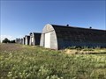 view gallery view gallerySW21.1 km |  Kragnes Farmers Elevator Co - Kragnes, MN Kragnes Farmers Elevator Co - Kragnes, MN
in Quonset Huts Nine Quonset huts lined up in Kragnes, MN. posted by: m&m O location: Minnesota date approved: 07/17/2020 last visited: never |
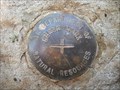
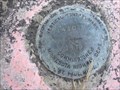 view gallery view galleryS22.2 km |  MNDT 1410 M 1979, Minnesota MNDT 1410 M 1979, Minnesota
in U.S. Benchmarks MNDT 1410 M 1979, MN, is a vertical control disk mounted at the southeast corner of the County Highway 9 bridge over the Buffalo River in Clay County, MN. posted by:  seventhings seventhings location: Minnesota date approved: 09/08/2006 last visited: never |
 view gallery view galleryS22.4 km | MNDT 1401 AW 1997, Minnesota in U.S. Benchmarks MNDT 1401 AW 1997, MN, is a vertical control disk mounted at the southeast corner of the US Highway 10 bridge over the Buffalo River in Clay County, MN. posted by: seventhings location: Minnesota date approved: 09/08/2006 last visited: never |
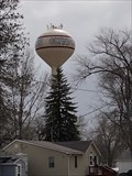 view gallery view galleryS23.3 km |  Glyndon Water Tower - Glyndon, MN Glyndon Water Tower - Glyndon, MN
in Water Towers This is the water tower for Glyndon, MN. posted by: m&m O location: Minnesota date approved: 08/11/2020 last visited: never |
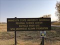 view gallery view galleryS23.8 km |  Regional Science Center - Glyndon, MN Regional Science Center - Glyndon, MN
in Nature Centers MSUM’s Regional Science Center strives to connect learning to the landscape by partnering and collaborating with Buffalo River State Park, The Nature Conservancy, the DNR and the MSUM Planetarium. posted by: m&m O location: Minnesota date approved: 10/16/2020 last visited: never |
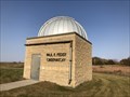 view gallery view galleryS23.8 km |  Paul P. Feder Observatory - Glyndon, MN Paul P. Feder Observatory - Glyndon, MN
in Astronomical Observatories Minnesota State University Moorhead's observatory, located in their outdoor science center. posted by: m&m O location: Minnesota date approved: 08/07/2022 last visited: never |
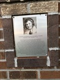
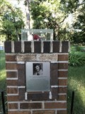 view gallery view gallerySW24 km |  Florence "Tree Tops" Klingensmith - Oak Mound, MN Florence "Tree Tops" Klingensmith - Oak Mound, MN
in Grave of a Famous Person The grave of Florence Klingensmith, who held multiple World Records, can be found at the Oak Mound Cemetery. posted by: m&m O location: Minnesota date approved: 07/21/2020 last visited: never |
 view gallery view gallerySW24 km |  FIRST - Licensed Aviatrix in Clay County, MN - Oak Mound, MN FIRST - Licensed Aviatrix in Clay County, MN - Oak Mound, MN
in First of its Kind Grave of "Tree Tops" Klingensmith, FIRST licensed female pilot in Clay County, MN and all of North Dakota. posted by: m&m O location: North Dakota date approved: 11/29/2020 last visited: never |
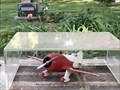 view gallery view gallerySW24 km |  Gee Bee Model Y Senior Sportster - Oak Mound, MN Gee Bee Model Y Senior Sportster - Oak Mound, MN
in Exact Replicas This is a model of the Gee Bee Sportster Florence Klingensmith was flying when she crashed and died. posted by: m&m O location: Minnesota date approved: 03/03/2021 last visited: never |
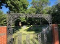 view gallery view gallerySW24 km |  Oak Mound Congregational Cemetery - Kragnes, MN Oak Mound Congregational Cemetery - Kragnes, MN
in Churchyard Cemeteries Oak Mound Cemetery, at Oak Mound Congregational Church, is two miles west of Kragnes, MN. posted by: m&m O location: North Dakota date approved: 07/21/2020 last visited: never |
 view gallery view gallery N24.1 km N24.1 km
|  Louis James Hauge, Jr.-Ada, MN Louis James Hauge, Jr.-Ada, MN
in Medal Of Honor Resting Places World War II Medal of Honor Recipient for action on Okinawa Shima on May 14, 1945. He remains were never recovered and he has a cenotaph “In Memory Of” marker in Ada Cemetery, Ada MN in the family cemetery plot. posted by: Don.Morfe location: Minnesota date approved: 11/08/2017 last visited: 12/19/2021 |
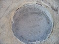
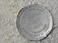
 view gallery view galleryS24.1 km | MN Department Of Natural Resources in U.S. Benchmarks Benchmark located inside the Buffalo River State Park, Glyndon, MN. Bronze disk set in concrete on South West corner of bridge. posted by: jeromehasbargen location: Minnesota date approved: 06/19/2011 last visited: never |
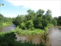 view gallery view galleryS24.3 km |  Buffalo River State Park - Glyndon, Minnesota Buffalo River State Park - Glyndon, Minnesota
in Scenic Overlooks A viewpoint atop the banks of the Buffalo River in Buffalo River State Park posted by: PM8 location: Minnesota date approved: 07/30/2016 last visited: 07/04/2021 |
 view gallery view gallerySW24.5 km | MNDT 1401 AT 2000, Minnesota in U.S. Benchmarks MNDT 1401 AT 2000, MN, is a vertical control disk mounted at the southeast corner of the US Highway 10 (westbound) Bridge over the South Fork of the Buffalo River in Clay County, MN. posted by: seventhings location: Minnesota date approved: 09/08/2006 last visited: never |
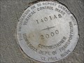 view gallery view gallerySW24.5 km | MNDT 1401 AS 2000, Minnesota in U.S. Benchmarks MNDT 1401 AS 2000, MN, is a vertical control disk mounted at the southeast corner of the US Highway 10 (eastbound) Bridge over the South Fork of the Buffalo River in Clay County, MN. posted by: seventhings location: Minnesota date approved: 09/08/2006 last visited: never |
 view gallery view gallerySW25.6 km |  Probstfield Organic Community Gardens - Moorhead, MN Probstfield Organic Community Gardens - Moorhead, MN
in Community Gardens The Probstfield Organic Community Garden is located at the intersection of 11th ST N/Oakport ST and 43rd AVE N in Moorhead. posted by: m&m O location: Minnesota date approved: 06/11/2020 last visited: never |
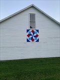 view gallery view gallerySW25.6 km |  Patriotic star - Moorhead MN Patriotic star - Moorhead MN
in Painted Barn Quilts Small star shaped barn quilt on a farm. posted by: Geojeepsters location: Minnesota date approved: 08/04/2023 last visited: never |
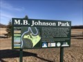 view gallery view gallerySW26.4 km |  River Keepers Nature and History Trail - Moorhead, MN River Keepers Nature and History Trail - Moorhead, MN
in Self Guided Walks and Trails This 1.5 mile trail is in MB Johnson Park, north of Moorhead. posted by: m&m O location: Minnesota date approved: 04/29/2021 last visited: never |
|