 view gallery view gallery SE3.4 km SE3.4 km
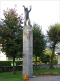
|   The Blackest Day The Blackest Day
in Plane Crash Sites 27 August 1938 was the blackest day in the history of the Swiss Air Force. posted by:  RakeInTheCache RakeInTheCache location: Schwyz, Switzerland date approved: 09/13/2007 last visited: never |
 view gallery view gallery NW6 km NW6 km
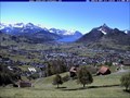
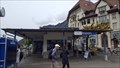
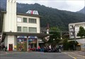
|  Webcam Schwyz - Schwyz, Switzerland Webcam Schwyz - Schwyz, Switzerland
in Web Cameras This webcam is on a hillside to the east of Schwyz and provides several views. posted by:  Lightnin Bug Lightnin Bug location: Schwyz, Switzerland date approved: 05/04/2024 last visited: never |
 view gallery view gallery W8.5 km W8.5 km
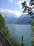
|  Urner See Overlook Urner See Overlook
in Scenic Roadside Look-Outs A scenic overlook of the beautiful mountain lake Urner See along the south bound A4 highway. posted by: RakeInTheCache location: Schwyz, Switzerland date approved: 08/30/2007 last visited: 01/03/2010 |
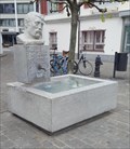
 view gallery view galleryW9.2 km |  Brunnen Schwyzer Bergbauer - Brunnen, SZ, Switzerland Brunnen Schwyzer Bergbauer - Brunnen, SZ, Switzerland
in Fountains A fountain in the center of Brunnen with a bust of a local mountain farmer by the sculptor Josef Bisa. posted by: fi67 location: Schwyz, Switzerland date approved: 06/08/2022 last visited: never |
 view gallery view galleryW9.2 km |  Schwyzer Bergbauer - Brunnen, SZ, Switzerland Schwyzer Bergbauer - Brunnen, SZ, Switzerland
in Occupational Monuments A fountain by the sculptor Josef Bisa in the center of Brunnen dedicated to the local mountain farmer. posted by: fi67 location: Schwyz, Switzerland date approved: 06/11/2022 last visited: never |
 view gallery view galleryW9.2 km |  Schiffsanlegestelle - Brunnen, SZ, Switzerland Schiffsanlegestelle - Brunnen, SZ, Switzerland
in Ferries and Ferry Landings The ferry landing of Brunnen in the northeast of Lake Lucerne. posted by: fi67 location: Schwyz, Switzerland date approved: 06/11/2022 last visited: never |
 view gallery view galleryW9.2 km |  Sundial at Rütli-Apotheke, Brunnen, SZ, Switzerland Sundial at Rütli-Apotheke, Brunnen, SZ, Switzerland
in Sundials A sundial at a pharmacie in the center of Brunnen. posted by: fi67 location: Schwyz, Switzerland date approved: 06/21/2022 last visited: never |
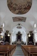
 view gallery view galleryW9.2 km |  Bundeskapelle - Brunnen, SZ, Switzerland Bundeskapelle - Brunnen, SZ, Switzerland
in Official Local Tourism Attractions A 17th century chapel in the location where the second federal oath of the Old Swiss Confederacy is said to have taken place in 1315. posted by: fi67 location: Schwyz, Switzerland date approved: 06/04/2022 last visited: never |
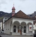 view gallery view galleryW9.2 km |  Bundeskapelle - Brunnen, SZ, Switzerland Bundeskapelle - Brunnen, SZ, Switzerland
in Roman Catholic Churches A 17th century chapel in the location where the second federal oath of the Old Swiss Confederacy is said to have taken place in 1315. posted by: fi67 location: Schwyz, Switzerland date approved: 06/07/2022 last visited: never |
 view gallery view galleryW9.2 km |  Bundeskapelle - Brunnen, SZ, Switzerland Bundeskapelle - Brunnen, SZ, Switzerland
in Austrian and Swiss National Heritage Sites A 17th century chapel in the location where the second federal oath of the Old Swiss Confederacy is said to have taken place in 1315. posted by: fi67 location: Schwyz, Switzerland date approved: 06/07/2022 last visited: never |
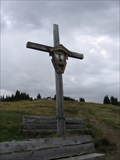 view gallery view gallery SW10.9 km SW10.9 km
|  Eggberge Cross Eggberge Cross
in Christian Crosses A cross erected high above the Urnersee in central Switzerland. posted by: RakeInTheCache location: Uri, Switzerland date approved: 08/29/2007 last visited: never |
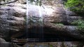
 view gallery view gallerySE13.7 km |  Glattalp Waterfall Glattalp Waterfall
in Waterfalls This unique waterfall is found part way up a cliff. The water emerges from a hole in the cliff. The water filters into the limestone bedrock above and exits here. posted by: RakeInTheCache location: Schwyz, Switzerland date approved: 08/29/2007 last visited: never |
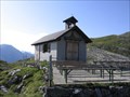 view gallery view gallerySE13.7 km |  Glattalp Kapelle Glattalp Kapelle
in Waychapels This chapel is located in a remote part of the Alps. It was built in 1939 to offer Sunday services to those few people living in the area and tourists. The community is almost exclusively Catholic. posted by: RakeInTheCache location: Schwyz, Switzerland date approved: 08/28/2007 last visited: never |
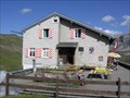 view gallery view gallerySE13.8 km |  SAC-Hütte Glattalp SAC-Hütte Glattalp
in Remote Backcountry Shelters The Swiss Alpine Club (SAC) has a network of alpine huts throughout Switzerland where normally you can sleep and have something to eat. This one is located in the beautiful Glattalp setting. posted by: RakeInTheCache location: Schwyz, Switzerland date approved: 08/28/2007 last visited: never |
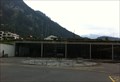
 view gallery view galleryNW15 km |  Arth-Goldau, SZ, Switzerland Arth-Goldau, SZ, Switzerland
in Train Stations/Depots Arth-Goldau is an important railway junction south of Lake Zug. posted by: fi67 location: Schwyz, Switzerland date approved: 08/19/2013 last visited: 02/15/2017 |
 view gallery view gallery E18 km E18 km
|  Barentritt - Switzerland Barentritt - Switzerland
in Elevation Signs Marker close to the top. posted by: superstein location: Glarus, Switzerland date approved: 09/20/2009 last visited: never |
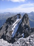 view gallery view galleryE18.2 km |  Ortstock Peak Glacier - Switzerland Ortstock Peak Glacier - Switzerland
in Glaciers A small glacier resting on the slope of a spur of Ortstock Peak. The glacier can only be admired from a safer point on Ortstock Peak which itself is accessible as a day hike. posted by: RakeInTheCache location: Glarus, Switzerland date approved: 09/04/2007 last visited: never |
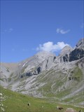 view gallery view galleryE18.3 km |  Ortstock Peak, Swiss Alps Ortstock Peak, Swiss Alps
in Mountain Summits Reaching Ortstock peak makes a nice hike for the well conditioned hiker through a beautiful alpine landscape. The peak is 2717 meters in elevation. posted by: RakeInTheCache location: Glarus, Switzerland date approved: 08/29/2007 last visited: never |
 view gallery view galleryW18.5 km | ") Gruebisbalm-Höhle - Vitznau, LU, Switzerland Gruebisbalm-Höhle - Vitznau, LU, Switzerland
in Cave Entrances (Natural) A cave behind a waterfall at the southern slope of Mount Rigi. posted by: fi67 location: Luzern, Switzerland date approved: 08/13/2012 last visited: never |
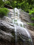 view gallery view galleryW18.5 km | Gruebisbalm-Wasserfall - Vitznau, LU, Switzerland in Waterfalls A waterfall at the southern slope of Mount Rigi with a natural cave behind it. posted by: fi67 location: Luzern, Switzerland date approved: 08/11/2012 last visited: 03/12/2017 |
 view gallery view galleryW18.5 km | Vitznau-Rigi-Bahn - Vitznau, LU, Switzerland in Train Stations/Depots The bottom station of Europe's oldest cog railway line in Vitznau. posted by: fi67 location: Luzern, Switzerland date approved: 09/07/2011 last visited: 05/14/2015 |
 view gallery view galleryW18.5 km | Turntable at Vitznau-Rigi-Bahn - Vitznau, LU, Switzerland in Railway Roundhouses The turntable at the base station of Europe's oldest cog railway is still in use. posted by: fi67 location: Luzern, Switzerland date approved: 09/09/2011 last visited: 05/14/2015 |
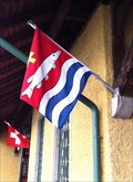 view gallery view galleryW18.5 km |  Municipal Flag - Vitznau, LU, Switzerland Municipal Flag - Vitznau, LU, Switzerland
in Municipal Flags The flag of Vitznau at the shipping pier. posted by: fi67 location: Luzern, Switzerland date approved: 09/07/2011 last visited: 05/14/2015 |
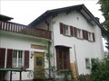 view gallery view galleryW19 km |  Hotel Gruebisbalm - Vitznau, LU, Switzerland Hotel Gruebisbalm - Vitznau, LU, Switzerland
in Recommended Accommodation A fully organic and natural hotel at the southern slope of Mount Rigi high above Lake Lucerne. posted by: fi67 location: Luzern, Switzerland date approved: 09/14/2011 last visited: never |
 view gallery view galleryW19.2 km |  Pfarrei Beckenried Church - Beckenried, Nidwalden, Switzerland Pfarrei Beckenried Church - Beckenried, Nidwalden, Switzerland
in Baroque Architecture Sie finden diese wunderschöne kleine Kirche am Ufer des Vierwaldstättersees. // You will find this beautiful small church on the shores of Lake Lucerne. posted by: Trail Blaisers location: Nidwalden, Switzerland date approved: 05/11/2018 last visited: 04/25/2020 |
|