 view gallery view gallery NE6.9 km NE6.9 km
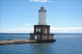
|   Portage Lake Lower Entry Light - Jacobsville Portage Lake Lower Entry Light - Jacobsville
in Coastal Lighthouses Portage Lake Lower Entry Light - Jacobsville posted by:  kJfishman kJfishman location: Michigan date approved: 08/11/2008 last visited: 08/11/2008 |
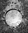 view gallery view galleryNE7.6 km |  PID RL: 1543 - Jacobsville MO PID RL: 1543 - Jacobsville MO
in U.S. Benchmarks PID RL: 1543 - Jacobsville MO posted by: kJfishman location: Michigan date approved: 01/22/2018 last visited: never |
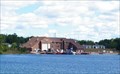
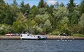 view gallery view galleryNE8.7 km |  Portage River Harbor of Refuge - Chassel MI Portage River Harbor of Refuge - Chassel MI
in Commercial Fishing Ports The Portage River Harbor of Refuge serves commercial port for Native American commercial fisherman. posted by: kJfishman location: Michigan date approved: 03/03/2017 last visited: never |
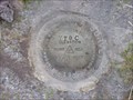 view gallery view galleryNE11.6 km | TT 9 C 1937 USGS in U.S. Benchmarks USGS BENCH MARK posted by:  Z15 Z15 location: Michigan date approved: 05/24/2006 last visited: never |
 view gallery view gallery S13.7 km S13.7 km
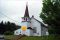
|  Zeba Indian United Methodist Church Zeba Indian United Methodist Church
in Michigan Historical Markers On the southeast corner of Whirl-I-Gig and Zeba Roads (I'm not kidding). Take Main Street/Skanee north out of L'Anse and after about 2.9 miles, bear left on Whirl-I-Gig until you come to Zeba Road on your right. Plenty of streetside parking. posted by: S5280ft location: Michigan date approved: 08/20/2006 last visited: never |
 view gallery view galleryS13.7 km |  Kewawenon Mission - Zeba, MI Kewawenon Mission - Zeba, MI
in U.S. National Register of Historic Places On the southeast corner of Whirl-I-Gig and Zeba Roads. Take Main Street/Skanee north out of L'Anse and after about 2.9 miles, bear left on Whirl-I-Gig until you come to Zeba Road on your right. Plenty of streetside parking. posted by: S5280ft location: Michigan date approved: 07/08/2008 last visited: never |
 view gallery view galleryS13.7 km |  Zeba Indian Mission United Methodist Church Zeba Indian Mission United Methodist Church
in This Old Church On the southeast corner of Whirl-I-Gig and Zeba Roads. Take Main Street/Skanee north out of L'Anse and after about 2.9 miles, bear left on Whirl-I-Gig until you come to Zeba Road on your right. Plenty of streetside parking. posted by: S5280ft location: Michigan date approved: 07/06/2008 last visited: never |
 view gallery view galleryS13.7 km |  59 Zeba Indian Church, L'Anse, MI 59 Zeba Indian Church, L'Anse, MI
in Historic United Methodist Sites On the southeast corner of Whirl-I-Gig and Zeba Roads. Take Main Street/Skanee north out of L'Anse and after about 2.9 miles, bear left on Whirl-I-Gig until you come to Zeba Road on your right. Plenty of streetside parking posted by: S5280ft location: Michigan date approved: 07/06/2008 last visited: 10/25/2011 |
 view gallery view galleryS17.5 km | Keweenaw Bay in Michigan Historical Markers On the east side of US-41 in a roadside park next to Keweenaw Bay. Plenty of parking in the roadside park. posted by: S5280ft location: Michigan date approved: 08/20/2006 last visited: 07/06/2007 |
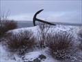 view gallery view galleryS17.7 km |  L'Anse Harbor Anchor - L'Anse, MI L'Anse Harbor Anchor - L'Anse, MI
in Anchors Anchor near L'Anse town harbor in L'Anse, Michigan. posted by: Team B Squared location: Michigan date approved: 01/28/2009 last visited: 06/09/2015 |
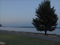
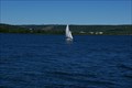 view gallery view gallery N18.7 km N18.7 km
|  Portage Lake - Manistee County Michigan Portage Lake - Manistee County Michigan
in Natural Lakes Portage Lake - Manistee County Michigan posted by: kJfishman location: Michigan date approved: 09/25/2017 last visited: never |
 view gallery view galleryS18.7 km | L'Anse - Lac Vieux Desert Trail in Michigan Historical Markers The marker is at the Bishop Baraga Shrine. It's hard to describe how to get there. It is on the south side of US-41 between L'anse and Baraga. Follow the signs to the Bishop Baraga Shrine. Park at the shrine parking lot. posted by: S5280ft location: Michigan date approved: 08/20/2006 last visited: 08/25/2014 |
 view gallery view gallery NW20 km NW20 km
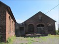
|  Baltic Mine - Baltic, MI Baltic Mine - Baltic, MI
in Mines The Baltic, located a few miles south of Houghton, was the find that opened up the southern part of Michigan's Keweenaw copper range in the late 1800's. posted by: linkys location: Michigan date approved: 09/03/2011 last visited: 08/20/2018 |
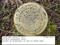 view gallery view galleryNW20.1 km | PRIM TRAV STA NO 4 1911 in U.S. Benchmarks A USGS PIPE CAP posted by: Z15 location: Michigan date approved: 11/27/2005 last visited: never |
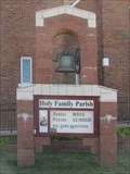 view gallery view galleryNW20.8 km |  Holy Family Bell - South Range, MI Holy Family Bell - South Range, MI
in Bells This bell sits in front of the catholic church at the end of TriMountain Avenue. posted by: linkys location: Michigan date approved: 09/03/2011 last visited: 08/20/2018 |
 view gallery view galleryNW20.8 km |  1937 - Holy Family Church - South Range, MI 1937 - Holy Family Church - South Range, MI
in Dated Buildings and Cornerstones Cornerstone on a Spanish Mission style church in Michigan's copper country. posted by: linkys location: Michigan date approved: 09/04/2011 last visited: 08/20/2018 |
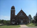 view gallery view galleryNW20.8 km | Holy Family - South Range, MI in Roman Catholic Churches Beautiful Spanish Mission style church at the end of the main street in South Range. posted by: linkys location: Michigan date approved: 09/03/2011 last visited: 08/20/2018 |
 view gallery view galleryN20.8 km |  Dreamland Hotel Bar - Dreamland, MI Dreamland Hotel Bar - Dreamland, MI
in Artistic Neon Lights Dreamland is an unincorporated community approximately 7 miles south of Lake Linden on Bootjack Road. posted by: S5280ft location: Michigan date approved: 08/16/2007 last visited: never |
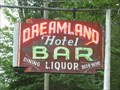 view gallery view galleryN20.8 km | Dreamland Hotel Bar - Dreamland, MI in Neon Signs Dreamland is an unincorporated community approximately 7 miles south of Lake Linden on Bootjack Road.
posted by: S5280ft location: Michigan date approved: 11/26/2007 last visited: never |
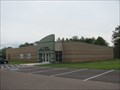
 view gallery view galleryN22 km |  Dollar Bay MI Coast Guard station Dollar Bay MI Coast Guard station
in Lifeboats and Rescue Stations Dollar Bay MI Coast Guard station posted by: kJfishman location: Michigan date approved: 10/21/2008 last visited: 10/21/2008 |
 view gallery view galleryN22.2 km |  The A. E. Seaman Mineral Museum - Houghton, MI The A. E. Seaman Mineral Museum - Houghton, MI
in Science Museums In a new building as of July 2011, this museum houses the world's best collection of crystallized native copper and native copper in crystallized calcite as part of one of the finest collections of minerals in North America. posted by: linkys location: Michigan date approved: 09/04/2011 last visited: never |
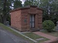 view gallery view galleryN22.4 km | Hoar Family Mausoleum in Michigan Historical Markers In the Forest Hill Cemetery with an entrance off of Sharon Avenue. Head up Macinnes drive, south from US-41 like you are going to the ice arena. posted by: S5280ft location: Michigan date approved: 08/20/2006 last visited: never |
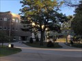 view gallery view galleryN23 km | Michigan Tech in Michigan Historical Markers My alma mater. On the south side of the campus where Macinnes Drive used to be. Plenty of parking at the University, but it can be tricky finding a spot when classes are in session. posted by: S5280ft location: Michigan date approved: 08/20/2006 last visited: 08/11/2017 |
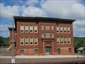 view gallery view galleryN23.5 km |  St. Ignatius School - Houghton, MI St. Ignatius School - Houghton, MI
in Former Schools Former parochial school located on Portage Street near St. Ignatius Loyola Church. posted by: linkys location: Michigan date approved: 09/04/2011 last visited: never |
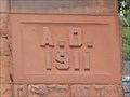 view gallery view galleryN23.5 km | 1911 - St. Ignatius School - Houghton, MI in Dated Buildings and Cornerstones Cornerstone on a long ago closed parochial school. posted by: linkys location: Michigan date approved: 09/05/2011 last visited: never |
|