 view gallery view gallery SW9.3 km SW9.3 km
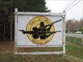
|   JM ASBESTOS INC - Jeffrey Pit and Mine, Asbestos, Quebec, Canada JM ASBESTOS INC - Jeffrey Pit and Mine, Asbestos, Quebec, Canada
in Mines A 'retired' open pit, reputedly the largest open pit mine in the Western world, with a still functioning underground mine. posted by:  bluelamb03 bluelamb03 location: Québec, Canada date approved: 02/26/2011 last visited: 07/24/2023 |
 view gallery view gallery S9.3 km S9.3 km
|  Poteau indicateur. Wotton, Québec, Canada Poteau indicateur. Wotton, Québec, Canada
in Direction and Distance Arrows Poteau indicateur de distance près de l'église.
Distance marker close to the church. posted by: Tarin99 location: Québec, Canada date approved: 10/27/2015 last visited: 04/24/2020 |
 view gallery view gallery W13.7 km W13.7 km
|  Sheikack sticker, Québec, canada Sheikack sticker, Québec, canada
in Waymark Sticker and Pin Seekers Take a pic's when you can!
Sur moi ou sur mon véhicule! posted by: sheikack location: Québec, Canada date approved: 12/23/2012 last visited: 08/15/2015 |
 view gallery view galleryW13.7 km | Liiki1 sticker, québec, canada in Waymark Sticker and Pin Seekers Take a pic's when you can!
Sur moi ou sur le véhicule qui me voyage... posted by: Liiki1 location: Québec, Canada date approved: 12/23/2012 last visited: 08/15/2015 |
 view gallery view galleryW13.7 km | Minisheikack sticker, québec, canada in Waymark Sticker and Pin Seekers Take a pic's when you can! Il est sur moi ou sur le véhicule qui me transporte. posted by:  minisheikack minisheikack location: Québec, Canada date approved: 12/23/2012 last visited: 08/15/2015 |
 view gallery view galleryW14.3 km |  A&W Danville, Quebec A&W Danville, Quebec
in A + W Restaurants Un nouveau restaurant avec commande a l'auto et places intérieures et extérieures. posted by: bigboy145 location: Québec, Canada date approved: 10/15/2012 last visited: 03/14/2016 |
 view gallery view galleryW14.5 km |  CP 434417, Danville, Qc CP 434417, Danville, Qc
in Train Cabooses Un wagon CP rail le long de la piste cycle. A CP rail train caboose along the cycle path. posted by: Lucky_Al location: Québec, Canada date approved: 09/09/2015 last visited: 09/12/2021 |
 view gallery view galleryW16.7 km |  Benchmark 96KSM20 - Kingsey Falls, Qc Benchmark 96KSM20 - Kingsey Falls, Qc
in Canadian Benchmarks Benchmark located between cycle path and Boul Tardif in Kingsey Falls, Qc posted by: nobellium location: Québec, Canada date approved: 06/25/2012 last visited: 07/20/2021 |
 view gallery view gallery NW17.5 km NW17.5 km
| Benchmark 1296 Kingsey Falls in Canadian Benchmarks Près de la croix de chemin - Near the cross posted by: Plaisirs et Cestmoi58 location: Québec, Canada date approved: 09/08/2009 last visited: 09/12/2021 |
 view gallery view galleryNW17.7 km |  Rocher de Fatima, Warwick, Qc Rocher de Fatima, Warwick, Qc
in Outdoor Altars Le Rocher de Fatima de Warwick // Warwick's Rock of Fatima posted by: Lucky_Al location: Québec, Canada date approved: 08/11/2020 last visited: 07/24/2021 |
 view gallery view galleryNW17.7 km |  N45° 56' W71° 59', Warwick, Qc, Canada N45° 56' W71° 59', Warwick, Qc, Canada
in Permanent Geographic Coordinates Latitude: 45° 56' Nord,
Longitude: 71° 59' Ouest.
Ces coordonnées sont inscrites sur le cadran solaire.
//
Latitude: 45° 56' North,
Longitude: 71° 59' West.
These coordinates are inscribed on the sundial. posted by: Lucky_Al location: Québec, Canada date approved: 08/12/2020 last visited: 09/12/2021 |
 view gallery view galleryNW17.7 km |  Le cadran solaire du Parc Fondation Étoiles d'Or, Warwick, Qc Le cadran solaire du Parc Fondation Étoiles d'Or, Warwick, Qc
in Sundials Le cadran solaire est situé dans le Parc Fondation Étoiles d'Or de Warwick // The sundial is located in the public park "Parc Fondation Étoiles d'Or" in Warwick. posted by: Lucky_Al location: Québec, Canada date approved: 08/15/2020 last visited: 09/12/2021 |
 view gallery view galleryNW18.7 km |  L'arche des Lion's (Warwick) L'arche des Lion's (Warwick)
in Lions Clubs International Markers L'arche des Lion's de Warwick
Lion's arch of Warwick posted by: gemeloj location: Québec, Canada date approved: 05/31/2012 last visited: 09/12/2021 |
 view gallery view galleryNW19.8 km | ") Pont Perreault-Charbonneau Pont Perreault-Charbonneau
in Histoire du Quebec (Quebec Historical Markers) Numéro / Number : 61-04-06 Aussi connu sous le nom de pont couvert de Warwick. posted by: VE2LHP location: Québec, Canada date approved: 03/14/2011 last visited: 06/09/2018 |
 view gallery view galleryNW19.8 km |  Le Pont Perrault, Warwick, Qc, Canada Le Pont Perrault, Warwick, Qc, Canada
in Covered Bridges Pont Perrault, construit en 1929, désaffecté depuis 1958, rénové en 2011, il est maintenant attrait touristique plus que jamais//Perrault Bridge, built in 1929, abandoned since 1958, renovated in 2011, it is now a tourist attraction more than ever. posted by: LeGrandChrist location: Québec, Canada date approved: 05/11/2015 last visited: 06/09/2018 |
 view gallery view gallery N24.1 km N24.1 km
|  Pisciculture Les Mousquetaires, Victoriaville, Qc, Canada Pisciculture Les Mousquetaires, Victoriaville, Qc, Canada
in Fish Hatcheries Le Club Chasse et Pêche Les Mousquetaires est une association qui a pour mission de promouvoir la chasse et la pêche // The Hunting and Fishing Club Les Mousquetaires has for mission to promote hunting and fishing posted by: LeGrandChrist location: Québec, Canada date approved: 05/16/2015 last visited: 06/02/2020 |
 view gallery view galleryN24.3 km |  Club de Tir Victoria - Victoriaville, Qc, Canada Club de Tir Victoria - Victoriaville, Qc, Canada
in Shooting Ranges Club de tir pour armes de poing, carabines et fusils
Shooting ranges for handguns, rifles and shotguns posted by: LeGrandChrist location: Québec, Canada date approved: 05/10/2015 last visited: 06/02/2020 |
 view gallery view galleryN24.5 km |  Suzor-Côté, cimetière Saint-Christophe-d'Arthabaska, Qc Suzor-Côté, cimetière Saint-Christophe-d'Arthabaska, Qc
in Grave of a Famous Person Marc-Aurèle de Foy Suzor-Côté peintre et sculteur // Marc-Aurèle de Foy Suzor-Côté painter and sculptor posted by: Lucky_Al location: Québec, Canada date approved: 05/30/2016 last visited: 07/17/2020 |
 view gallery view galleryN24.5 km |  Suzor-Côté, cimetière Saint-Christophe-d'Arthabaska, Qc Suzor-Côté, cimetière Saint-Christophe-d'Arthabaska, Qc
in Death Mask Gravestones Marc-Aurèle de Foy Suzor-Côté peintre et sculteur // Marc-Aurèle de Foy Suzor-Côté painter and sculptor posted by: Lucky_Al location: Québec, Canada date approved: 05/22/2016 last visited: 06/14/2024 |
 view gallery view galleryN24.5 km |  La Maison d’école du rang Cinq-Chicots, St-Christophe d'Arthabaska, Qc, Canada La Maison d’école du rang Cinq-Chicots, St-Christophe d'Arthabaska, Qc, Canada
in Former Schools Une belle école de rang typique du Québec d'autrefois / A beautiful typical schoolhouse of old Quebec posted by: Lucky_Al location: Québec, Canada date approved: 09/19/2016 last visited: 07/22/2020 |
 view gallery view galleryN24.5 km |  La Maison d’école du rang Cinq-Chicots, St-Christophe d'Arthabaska, Qc La Maison d’école du rang Cinq-Chicots, St-Christophe d'Arthabaska, Qc
in One-Room Schoolhouses Une belle école de rang typique du Québec d'autrefois / A beautiful typical schoolhouse of old Quebec posted by: Lucky_Al location: Québec, Canada date approved: 08/05/2015 last visited: 07/22/2020 |
 view gallery view galleryN24.5 km | Maison d'école du rang Cinq-Chicots in Histoire du Quebec (Quebec Historical Markers) Une belle école de rang typique du Québec d'autrefois / A beautiful typical schoolhouse of old Quebec posted by: Lucky_Al location: Québec, Canada date approved: 11/20/2016 last visited: 07/22/2020 |
 view gallery view galleryN24.6 km |  Croix du Mt St Michel-Victoriaville- Québec,Canada Croix du Mt St Michel-Victoriaville- Québec,Canada
in Christian Crosses Une belle Croix sur notre route! a nice cross on our road! posted by: gemeloj location: Québec, Canada date approved: 06/20/2013 last visited: 09/04/2018 |
 view gallery view galleryN24.8 km |  Velo de montagne-Victoriaville-Québec, Canada Velo de montagne-Victoriaville-Québec, Canada
in Mountain Bike Trailheads Un superbe sentier! a superb trail! posted by: gemeloj location: Québec, Canada date approved: 06/08/2014 last visited: 01/10/2022 |
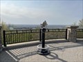 view gallery view galleryN24.8 km |  BINO - Vue du Mont Arthabaska, Victoriaville, Qc BINO - Vue du Mont Arthabaska, Victoriaville, Qc
in Coin-Op Binoculars Belle vue de Victoriaville et la région des Bois-Francs // Beautiful view of Victoriaville and the Bois-Francs region posted by: Lucky_Al location: Québec, Canada date approved: 05/15/2022 last visited: 11/23/2022 |
|