 view gallery view gallery SE9.3 km SE9.3 km
|   Zigzag, Oregon Zigzag, Oregon
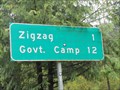
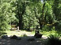
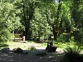
in 'Z' Welcome Signs Zigzag is a small mountain community in the Mt. Hood corridor of Oregon. posted by:  DougK DougK location: Oregon date approved: 05/07/2010 last visited: 01/11/2014 |
 view gallery view gallerySE9.7 km |  Zigzag Ranger Station - Zigzag, OR Zigzag Ranger Station - Zigzag, OR
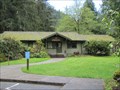
in U.S. National Register of Historic Places The Zigzag Ranger Station consists of nineteen historic buildings on 125 acres in Mt. Hood National Forest or Oregon. posted by: DougK location: Oregon date approved: 05/07/2010 last visited: 11/10/2019 |
 view gallery view gallerySE9.7 km |  Zigzag Ranger Station - Mt. Hood National Forest - Zigzag, OR Zigzag Ranger Station - Mt. Hood National Forest - Zigzag, OR
in Ranger Stations The Zigzag Ranger Station serves the Mt. Hood National Forest area. posted by: DougK location: Oregon date approved: 05/11/2010 last visited: 11/10/2019 |
 view gallery view gallery SW9.8 km SW9.8 km
|  LARGEST - Bear in the World, Alder Creek, Clackamas County, Oregon LARGEST - Bear in the World, Alder Creek, Clackamas County, Oregon
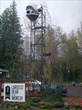
in Superlatives Not the Polar Bear, but the Ivy Bear is reputedly 'The Largest Bear in the World'. posted by: greysman location: Oregon date approved: 11/21/2013 last visited: 11/10/2019 |
 view gallery view gallery S10 km S10 km
|  Red Telephone Box, Welches Oregon Red Telephone Box, Welches Oregon
in Red Telephone Boxes A excellent example of a classic British red telephone box stands just outside the Pro Shop of "The Courses" golf course at "The Resort at the Mountain" near Mt Hood Oregon. A standard US pay phone is now mounted inside but not in working order. posted by:  arby101ca arby101ca location: Oregon date approved: 09/27/2014 last visited: never |
 view gallery view gallerySE12.1 km |  The Oregon Trail 1845 -- Rhododendron, OR, USA The Oregon Trail 1845 -- Rhododendron, OR, USA
in Daughters of the American Revolution An Oregon Trail plaque in Rhododendron OR marks the Barlow Road route of the old emigrant road posted by: Benchmark Blasterz location: Oregon date approved: 06/28/2023 last visited: 12/20/2023 |
 view gallery view galleryS12.4 km |  Huckleberry Mountain Huckleberry Mountain
in U.S. Benchmarks Located on the Plaza Trail at qprox 4114 ft. Damaged and and only partially legible. U.S. General Land Office Survey posted by: waffle stomper location: Oregon date approved: 07/01/2006 last visited: never |
 view gallery view galleryS12.9 km |  Jon Morris and Richard Cauthorn - Portland, OR. Jon Morris and Richard Cauthorn - Portland, OR.
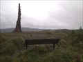
in Dedicated Benches Dedicated bench with a great scenic view from a mountain top. posted by: Tprints location: Oregon date approved: 11/27/2011 last visited: 08/19/2013 |
 view gallery view gallerySE13.4 km |  Barlow Tollgate Big Leaf Maples, Oregon Barlow Tollgate Big Leaf Maples, Oregon
in Historic Trees These big leaf maples witness the immigration of the pioneers over the Oregon Trail. posted by: Queens Blessing location: Oregon date approved: 07/12/2009 last visited: 11/10/2019 |
 view gallery view gallerySE13.4 km |  Barlow Road Tollgate, Mount Hood, Oregon Barlow Road Tollgate, Mount Hood, Oregon
in Wagon Roads and Trails This Tollgate was the first toll road on the Oregon Trail. posted by: Queens Blessing location: Oregon date approved: 07/11/2009 last visited: 11/10/2019 |
 view gallery view gallery E15.6 km E15.6 km
|  Mount Hood - Oregon Mount Hood - Oregon
in Wikipedia Entries Mount Hood is a mountain in Oregon. posted by: saopaulo1 location: Oregon date approved: 06/30/2017 last visited: 11/10/2019 |
 view gallery view gallery NE15.8 km NE15.8 km
|  Lost Lake Boardwalk, Oregon Lost Lake Boardwalk, Oregon
in Non-Coastal Boardwalks Around the beautiful Lost Lake in the Mt Hood National Forest is a boardwalk with picturesque views. posted by: DocDTA location: Oregon date approved: 12/28/2013 last visited: 12/30/2013 |
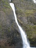
 view gallery view gallery N18.2 km N18.2 km
|  Oneonta Falls Oneonta Falls
in Waterfalls The 65 foot Oneonta Falls is hidden from view and the main path bypasses it completely. The falls is rare treat for those who seek it. posted by: PYNEKONE location: Oregon date approved: 08/29/2011 last visited: 08/18/2011 |
 view gallery view galleryN18.5 km | Triple Falls in Waterfalls Triple Falls is considered one of the prettiest waterfalls in the Columbia River Gorge along Oneonta Creek. posted by: PYNEKONE location: Oregon date approved: 08/31/2011 last visited: 08/31/2011 |
 view gallery view galleryN19.2 km | Upper Oneonta Falls - Columbia River Highway, Oregon in Waterfalls Upper Oneonta Falls and the Oneonta Gorge are accessed from the trail adjacent to the roadside Horsetail Falls. The Forest Service has designated the area as a botanical area because of the unique aquatic and woodland plants that grow there. posted by: Hikenutty location: Oregon date approved: 01/05/2008 last visited: 10/18/2008 |
 view gallery view galleryN19.3 km | Lower Oneonta Falls in Waterfalls 100 foot Plunge style waterfall in the Columbia River Gorge posted by: PYNEKONE location: Oregon date approved: 08/28/2011 last visited: 08/29/2011 |
 view gallery view gallerySE19.3 km |  Laurel Hill Laurel Hill
in Oregon Historical Markers Historic Oregon Trail marker on U.S. Hwy. 26 near Mt. Hood. posted by: Volcanoguy location: Oregon date approved: 10/17/2008 last visited: 11/10/2019 |
 view gallery view galleryN19.5 km |  Oneonta Gorge Oneonta Gorge
in Places of Geologic Significance The Oneonta Gorge is a slot canyon 20 feet wide, 250 feet deep and is one-fourth mile long. A crack in the ground is as straight as an arrow. The Gorge is a Nature Preserve protecting the rare plants and the unique shear basalt walls. posted by: PYNEKONE location: Oregon date approved: 08/29/2011 last visited: 04/26/2012 |
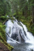 view gallery view gallerySE19.6 km | Little Zig Zag Falls - Mt. Hood area, Oregon in Waterfalls Little Zig Zag Falls is a 75 foot slide style waterfall on the Little Zig Zag river. The river and falls are fed by the Zig Zag Glacier on Mt. Hood. posted by: Hikenutty location: Oregon date approved: 01/02/2008 last visited: 01/02/2008 |
 view gallery view gallery NW19.6 km NW19.6 km
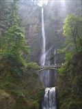
| Multnomah Falls in Waterfalls This amazing waterfall is the third tallest in the United States. posted by: cachegame location: Oregon date approved: 10/21/2006 last visited: 12/30/2022 |
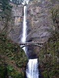 view gallery view galleryNW19.6 km | Multnomah Falls - Oregon in Wikipedia Entries Well known and tallest waterfall in Oregon. posted by:  BruceS BruceS location: Oregon date approved: 02/15/2010 last visited: 12/30/2022 |
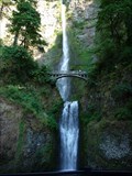 view gallery view galleryNW19.6 km |  Multnomah Falls - Historic Columbia River Hightway - OR Multnomah Falls - Historic Columbia River Hightway - OR
in National Scenic Byways This spectacular fall is the second largest in the US. posted by: nomadwillie location: Oregon date approved: 01/12/2012 last visited: 12/30/2022 |
 view gallery view galleryN19.6 km | Horsetail Falls - Oregon in Wikipedia Entries N 45° 35.408 W 122° 04.127
10T E 572636 N 5048931
Quick Description: Waterfalls easily accessible from the Columbia River Highway. posted by: BruceS location: Oregon date approved: 02/15/2010 last visited: 07/10/2017 |
 view gallery view galleryN19.6 km |  Horsetail Falls - Columbia River Highway Horsetail Falls - Columbia River Highway
in American Guide Series Waterfalls easily accessible from the Columbia River Highway.
posted by: BruceS location: Oregon date approved: 03/02/2009 last visited: 11/27/2020 |
 view gallery view galleryN19.6 km |  Mom dies, 3-year-old hurt in fall at Horsetail Falls Mom dies, 3-year-old hurt in fall at Horsetail Falls
in News Article Locations A fall at a waterfall in Oregon. posted by: saopaulo1 location: Oregon date approved: 07/12/2022 last visited: never |
|