 view gallery view gallery SW15.6 km SW15.6 km
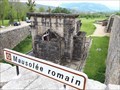
|   Mausolée de Lanuéjols - Lanuéjols (Lozère) Mausolée de Lanuéjols - Lanuéjols (Lozère)
in Ancient Roman Civilization [FR] Le mausolée de Lanuéjols fut élevé par une riche famille à la mémoire de ses deux fils. [EN] The mausoleum of Lanuéjols was built by a rich family in memory of two sons. posted by:  RakeInTheCache RakeInTheCache location: Occitanie, France date approved: 06/09/2018 last visited: never |
 view gallery view gallery E18.3 km E18.3 km
|  Source des Caquets - Saint-Laurent-les-Bains (Ardèche), France Source des Caquets - Saint-Laurent-les-Bains (Ardèche), France
in Hot Springs [FR] Les eaux chaudes de Saint Laurent les Bains émergent d’une fissure rocheuse longue de près de 2500 mètres de profondeur. [EN] The hot water of Saint Laurent les Bains emerges from a rocky fissure 2500 meters deep. posted by: RakeInTheCache location: Auvergne-Rhône-Alpes, France date approved: 06/30/2011 last visited: never |
 view gallery view gallery SE20 km SE20 km
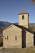
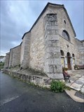
|  La chapelle saint Jean- Villefort- Lozère- Languedoc-Roussillon- France La chapelle saint Jean- Villefort- Lozère- Languedoc-Roussillon- France
in Monuments Historiques Français La chapelle st Jean posted by: SISABIEL location: Occitanie, France date approved: 11/23/2017 last visited: never |
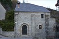 view gallery view gallerySE20 km |  La chapelle saint Jean- Villefort- Lozère- Languedoc-Roussillon- France La chapelle saint Jean- Villefort- Lozère- Languedoc-Roussillon- France
in Roman Catholic Churches La chapelle Saint Jean. posted by: SISABIEL location: Occitanie, France date approved: 11/22/2017 last visited: never |
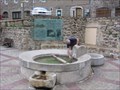
 view gallery view gallerySE20 km | ") Le lavoir- Villefort- Lozère- Languedoc-Roussillon- France Le lavoir- Villefort- Lozère- Languedoc-Roussillon- France
in Lavoir (wash houses) Le lavoir de Villefort posted by: SISABIEL location: Occitanie, France date approved: 11/22/2017 last visited: never |
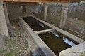
 view gallery view gallerySE20 km | Le pont Saint Jean- Villefort- Lozère- Languedoc-Roussillon- France in Monuments Historiques Français Le pont romain de Villefort posted by: SISABIEL location: Occitanie, France date approved: 11/22/2017 last visited: never |
 view gallery view gallerySE20 km |  Le pont Saint Jean- Villefort- Lozère- Languedoc-Roussillon- France Le pont Saint Jean- Villefort- Lozère- Languedoc-Roussillon- France
in Arch Bridges le pont romain posted by: SISABIEL location: Occitanie, France date approved: 11/22/2017 last visited: never |
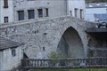 view gallery view gallerySE20 km |  Le pont Saint Jean- Villefort- Lozère- Languedoc-Roussillon- France Le pont Saint Jean- Villefort- Lozère- Languedoc-Roussillon- France
in Stone Bridges Le pont romain Saint Jean à Villefort. posted by: SISABIEL location: Occitanie, France date approved: 12/11/2017 last visited: never |
 view gallery view gallerySE25.4 km | L'Eglise Notre Dame- Ponteils et Brésis- Gard- Languedoc-Roussillon- France in This Old Church Eglise de Notre Dame à Ponteils et Brésis. posted by: SISABIEL location: Occitanie, France date approved: 11/23/2017 last visited: never |
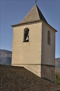 view gallery view gallerySE25.4 km |  Le clocher de l'Eglise Notre Dame- Ponteils et Brésis- Gard- Languedoc-Roussillon- France Le clocher de l'Eglise Notre Dame- Ponteils et Brésis- Gard- Languedoc-Roussillon- France
in Bell Towers Le clocher de l'Eglise Notre Dame. posted by: SISABIEL location: Occitanie, France date approved: 11/22/2017 last visited: never |
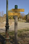 view gallery view gallerySE25.6 km |  546m- Ponteils- Ponteils et Brésis- Gard- languedoc-Roussillon- France 546m- Ponteils- Ponteils et Brésis- Gard- languedoc-Roussillon- France
in Elevation Signs Panneau indicateur pour les randonneurs. posted by: SISABIEL location: Occitanie, France date approved: 11/22/2017 last visited: never |
 view gallery view gallery NE38 km NE38 km
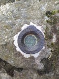
|  benchmark lac d issarles,France benchmark lac d issarles,France
in French Benchmarks sur un rocher posted by: sara et gege location: Auvergne-Rhône-Alpes, France date approved: 08/12/2018 last visited: 11/26/2018 |
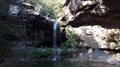 view gallery view galleryE38 km |  Cascade de Beaumicou, Ardèche, France Cascade de Beaumicou, Ardèche, France
in Waterfalls [FR] Cascade naturelle à côté des tétines [EN] Natural waterfall next to the teats posted by: Blanko36 location: Auvergne-Rhône-Alpes, France date approved: 10/11/2022 last visited: 10/11/2022 |
 view gallery view gallery N38.6 km N38.6 km
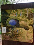
|  Lac du Bouchet - Cayres, France Lac du Bouchet - Cayres, France
in Wikipedia Entries [EN] Surrounded by greenery, this lake is nestled in one of the most beautiful maar craters in all of Auvergne.
[FR] Entouré de verdure, ce lac est niché dans l'un des plus beaux cratères de maar de toute l’Auvergne. posted by: pmaupin location: Auvergne-Rhône-Alpes, France date approved: 07/02/2023 last visited: never |
 view gallery view galleryN38.6 km |  Lac du Bouchet - Cayres, France Lac du Bouchet - Cayres, France
in Official Local Tourism Attractions [EN] Surrounded by greenery, this lake is nestled in one of the most beautiful maar craters in all of Auvergne. [FR] Entouré de verdure, ce lac est niché dans l'un des plus beaux cratères de maar de toute l’Auvergne. posted by: pmaupin location: Auvergne-Rhône-Alpes, France date approved: 07/02/2023 last visited: never |
 view gallery view galleryN38.6 km |  Lac du Bouchet - Cayres, France Lac du Bouchet - Cayres, France
in Natural Lakes [EN] Surrounded by greenery, this lake is nestled in one of the most beautiful maar craters in all of Auvergne. [FR] Entouré de verdure, ce lac est niché dans l'un des plus beaux cratères de maar de toute l’Auvergne posted by: pmaupin location: Auvergne-Rhône-Alpes, France date approved: 07/02/2023 last visited: never |
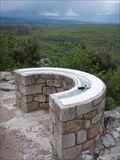
 view gallery view gallery W38.8 km W38.8 km
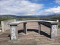
|  Table d'orientation sur l'aire de Marvejols - Régourdel, France Table d'orientation sur l'aire de Marvejols - Régourdel, France
in Orientation Tables [EN] A beautiful orientation table on the Marvejols area, on the A75 motorway.
[FR] Une belle table d'orientation sur l'Aire de Marvejols, sur l'autoroute A75. posted by: pmaupin location: Occitanie, France date approved: 11/22/2023 last visited: never |
 view gallery view gallerySE39.1 km | Table du fort de Banne (07) in Orientation Tables Table située à une extrémité du château. Elle offre un magnifique panorama. posted by: Pat5488 location: France date approved: 04/19/2009 last visited: never |
 view gallery view galleryE39.4 km | Thuyets, Ardèche, France in Orientation Tables Table d'orientation qui domine la rivière Ardèche. posted by: The_dahu location: France date approved: 08/29/2008 last visited: never |
 view gallery view galleryE39.4 km |  Le pont du diable - Thueyts - France Le pont du diable - Thueyts - France
in Man-made Devilish Locations Le Pont du Diable, situé tout près du village de Thueyts, au cœur du Parc Naturel Régional des Monts d'Ardèche.
Le Pont du Diable, located near the village of Thueyts, in the heart of the Regional Natural Park of the Monts d'Ardèche. posted by: Alfouine location: Auvergne-Rhône-Alpes, France date approved: 09/24/2017 last visited: 11/14/2021 |
 view gallery view galleryE39.4 km | Le pont du diable - Thueyts - France in Official Local Tourism Attractions Le Pont du Diable, situé tout près du village de Thueyts, au cœur du Parc Naturel Régional des Monts d'Ardèche.
Le Pont du Diable, located near the village of Thueyts, in the heart of the Regional Natural Park of the Monts d'Ardèche. posted by: Alfouine location: Auvergne-Rhône-Alpes, France date approved: 09/24/2017 last visited: 11/14/2021 |
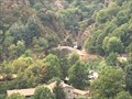 view gallery view galleryE39.4 km |  Le pont du diable - Thueyts - France Le pont du diable - Thueyts - France
in News Article Locations Le Pont du Diable, situé tout près du village de Thueyts, au cœur du Parc Naturel Régional des Monts d'Ardèche.
Le Pont du Diable, located near the village of Thueyts, in the heart of the Regional Natural Park of the Monts d'Ardèche. posted by: Alfouine location: Auvergne-Rhône-Alpes, France date approved: 09/24/2017 last visited: 11/14/2021 |
 view gallery view galleryE39.4 km | Le pont du diable - Thueyts - France in Wikipedia Entries Le Pont du Diable, situé tout près du village de Thueyts, au cœur du Parc Naturel Régional des Monts d'Ardèche.
Le Pont du Diable, located near the village of Thueyts, in the heart of the Regional Natural Park of the Monts d'Ardèche. posted by: Alfouine location: Auvergne-Rhône-Alpes, France date approved: 09/25/2017 last visited: 11/14/2021 |
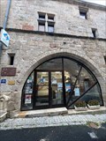 view gallery view gallery NW40.6 km NW40.6 km
|  Office du Tourisme - Aumont-Aubrac - Lozère - Occitanie - FRA Office du Tourisme - Aumont-Aubrac - Lozère - Occitanie - FRA
in Tourist Information Centers - Visitor Centers Petit office du tourisme. De nombreuses idées de sortie dans la ville et des idées de circuits dans la région.
(ENG) Small tourist office. Many ideas for outings in the city and ideas for circuits in the region. posted by: lynx36 location: Occitanie, France date approved: 12/08/2023 last visited: 12/08/2023 |
 view gallery view galleryNW40.6 km | Eglise St Etienne - Aumont Aubrac - Lozère - Occitanie - FRA in Roman Catholic Churches Église Saint-Étienne au mélange de styles roman et baroque.
Mentionnée dès l’an 1106. posted by: lynx36 location: Occitanie, France date approved: 12/08/2023 last visited: 12/08/2023 |
|