 view gallery view gallery W0.2 km W0.2 km
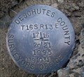
|   T16S R13E S17 16 1/4 COR - Deschutes County, OR T16S R13E S17 16 1/4 COR - Deschutes County, OR
in Public Land Survey Marks PLSS quarter corner set by WHPacific, Parneli J. Perkins in 2000 posted by:  Cooke17513 Cooke17513 location: Oregon date approved: 02/17/2014 last visited: never |
 view gallery view gallery S0.8 km S0.8 km
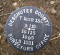
| T16S R13E S17 16 20 21 COR - Deschutes County, OR in Public Land Survey Marks PLSS section corner set by Deschutes County Surveyors Office, W.C. Kauffman in 1995 posted by: Cooke17513 location: Oregon date approved: 02/15/2014 last visited: never |
 view gallery view gallery N0.8 km N0.8 km
| T16S R13E S8 9 17 16 COR - Deschutes County, OR in Public Land Survey Marks PLSS section corner set by Deschutes County Surveyors Office, W.C. Kauffman in 1995 posted by: Cooke17513 location: Oregon date approved: 02/14/2014 last visited: never |
 view gallery view gallery E1.4 km E1.4 km
| T16S R13E S16 15 1/4 COR - Deschutes County, OR in Public Land Survey Marks PLSS quarter corner set by WHPacific, Parneli J. Perkins in 2000 posted by: Cooke17513 location: Oregon date approved: 02/15/2014 last visited: never |
 view gallery view gallery SE1.6 km SE1.6 km
| T16S R13E S16 15 21 22 COR - Deschutes County, OR in Public Land Survey Marks PLSS section corner set by Deschutes County Surveyors Office, W.C. Kauffman in 1995 posted by: Cooke17513 location: Oregon date approved: 02/15/2014 last visited: never |
 view gallery view gallery NE1.8 km NE1.8 km
| T16S R13E S9 10 16 15 COR - Deschutes County, OR in Public Land Survey Marks PLSS section corner set by Deschutes County Surveyors Office, W.C. Kauffman in 1995 posted by: Cooke17513 location: Oregon date approved: 02/15/2014 last visited: never |
 view gallery view gallery SW1.9 km SW1.9 km
| T16S R13E S18 17 19 20 COR - Deschutes County, OR in Public Land Survey Marks PLSS section corner set by Deschutes County Surveyors Office, W.C. Kauffman in 1995 posted by: Cooke17513 location: Oregon date approved: 01/28/2014 last visited: never |
 view gallery view gallery NW1.9 km NW1.9 km
| T16S R13E S7 8 18 17 COR - Deschutes County, OR in Public Land Survey Marks PLSS section corner set by Deschutes County Surveyors Office, W.C. Kauffman in 1995 posted by: Cooke17513 location: Oregon date approved: 01/23/2014 last visited: never |
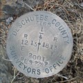 view gallery view galleryW3.4 km | T16S R12E S13 R13E S18 1/4 COR - Deschutes County, OR in Public Land Survey Marks PLSS quarter corner set by Deschutes County Surveyors Office, Kenneth L. Grantham in 2001 posted by: Cooke17513 location: Oregon date approved: 01/22/2014 last visited: never |
![Image for T15S R13E S32 33 [T16S R13E S5] SC COR - Deschutes County, OR](https://img.geocaching.com/waymarking/small/a9441218-5d2b-4fd1-ad2c-a6df5f906244.jpg) view gallery view galleryN3.4 km | T15S R13E S32 33 [T16S R13E S5] SC COR - Deschutes County, OR in Public Land Survey Marks PLSS standard corner and Central Oregon Grid mark, designated 15133300; US Department of the Interior, Bureau of Land Management cap set by Richard S. Kaiser in 2007 posted by: Cooke17513 location: Oregon date approved: 03/07/2012 last visited: never |
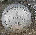
 view gallery view galleryW3.4 km | T16S R12E S12 13 R13E S7 18 COR - Deschutes County, OR in Public Land Survey Marks PLSS section corner set by Deschutes County Surveyors Office, W.C. Kauffman in 1995 posted by: Cooke17513 location: Oregon date approved: 01/21/2014 last visited: never |
![Image for T15S R13E S33 34 [T16S R13E S4] SC COR - Deschutes County, OR](https://img.geocaching.com/waymarking/small/6529cca1-fb45-46b6-acd4-bbfb4b90d445.jpg) view gallery view galleryN3.5 km | T15S R13E S33 34 [T16S R13E S4] SC COR - Deschutes County, OR in Public Land Survey Marks Central Oregon Grid mark designated 15133400; PLSS standard corner set by Deschutes County Surveyors Office, Kenneth L. Grantham in 1994 posted by: Cooke17513 location: Oregon date approved: 01/05/2014 last visited: never |
 view gallery view gallerySW3.7 km | T16S R12E S24 R13E S19 1/4 COR - Deschutes County, OR in Public Land Survey Marks PLSS quarter corner set by Deschutes County Surveyors Office, Kenneth L. Grantham in 2002 posted by: Cooke17513 location: Oregon date approved: 01/27/2014 last visited: never |
![Image for T15S R13E S32 [T16S R13E S5] SC 1/4 COR - Deschutes County, OR](https://img.geocaching.com/waymarking/small/894bfdf7-3297-4f4b-8a1b-08ef1abd5997.jpg) view gallery view galleryNW3.7 km | T15S R13E S32 [T16S R13E S5] SC 1/4 COR - Deschutes County, OR in Public Land Survey Marks PLSS standard quarter corner; US Department of the Interior, Bureau of Land Management cap set by Richard S. Kaiser in 2007 posted by: Cooke17513 location: Oregon date approved: 03/07/2012 last visited: never |
 view gallery view galleryNW3.7 km | T16S R13E S6 5 1/4 COR - Deschutes County, OR in Public Land Survey Marks PLSS quarter corner set by Deschutes County Surveyors Office, W.C. Kauffman in 1995 posted by: Cooke17513 location: Oregon date approved: 01/09/2014 last visited: never |
![Image for [T15S R13E S32] T16S R13E S6 5 CC COR - Deschutes County, OR](https://img.geocaching.com/waymarking/small/e9c761d5-cdeb-4abe-bc16-a7ddc9654112.jpg) view gallery view galleryNW3.9 km | [T15S R13E S32] T16S R13E S6 5 CC COR - Deschutes County, OR in Public Land Survey Marks PLSS closing corner originally established by Bureau of Land Management, Henry Meldrum in 1880 posted by: Cooke17513 location: Oregon date approved: 01/07/2014 last visited: never |
![Image for T15S R13E S34 [T16S R13E S3] SC 1/4 COR - Deschutes County, OR](https://img.geocaching.com/waymarking/small/8f942936-756b-46eb-bd37-6189a9180130.jpg) view gallery view galleryNE3.9 km | T15S R13E S34 [T16S R13E S3] SC 1/4 COR - Deschutes County, OR in Public Land Survey Marks PLSS standard quarter corner; Deschutes County Surveyors Office cap set by Kenneth L. Grantham in 1994 posted by: Cooke17513 location: Oregon date approved: 03/08/2012 last visited: never |
![Image for T15S R13E S32 [T16S R13E S6] W 1/16 COR - Deschutes County, OR](https://img.geocaching.com/waymarking/small/9dcb6ec5-bf93-4cc1-a729-7b1d3848681c.jpg) view gallery view galleryNW3.9 km | T15S R13E S32 [T16S R13E S6] W 1/16 COR - Deschutes County, OR in Public Land Survey Marks PLSS sixteenth corner set by Oregon State Parks, John E. Hollingsworth in 1978 posted by: Cooke17513 location: Oregon date approved: 01/09/2014 last visited: never |
 view gallery view galleryN4 km | T15S R13E S32 S 1/16 COR - Deschutes County, OR in Public Land Survey Marks PLSS sixteenth corner set by Oregon State Parks, John E. Hollingsworth in 1978 posted by: Cooke17513 location: Oregon date approved: 01/11/2014 last visited: never |
![Image for T15S R13E S31 32 [T16S R13E S6] SC COR - Deschutes County, OR](https://img.geocaching.com/waymarking/small/875648be-0d29-4a08-9e31-372807892800.jpg) view gallery view galleryNW4 km | T15S R13E S31 32 [T16S R13E S6] SC COR - Deschutes County, OR in Public Land Survey Marks PLSS standard corner and Central Oregon Grid mark, designated 15133200; Deschutes County Surveyors Office cap set by W.C. Kauffman in 1995 posted by: Cooke17513 location: Oregon date approved: 03/07/2012 last visited: never |
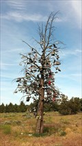 view gallery view galleryNW4 km |  Hwy 97 Shoe Tree - Redmond, OR Hwy 97 Shoe Tree - Redmond, OR
in Shoe Trees This dead tree is one of two shoe trees we spotted along Hwy 97. This tree is featured on RoadsideAmerica.com. posted by: NW_history_buff location: Oregon date approved: 07/28/2015 last visited: never |
 view gallery view galleryNW4.2 km |  T 16 S, R 12-13 E, Sec Corner 1, 6, 7, 12, Oregon T 16 S, R 12-13 E, Sec Corner 1, 6, 7, 12, Oregon
in U.S. Benchmarks Cap for T 16 S, R 12-13 E, Sec. Corner 1, 6, 7, 12. posted by: Volcanoguy location: Oregon date approved: 02/09/2006 last visited: never |
 view gallery view galleryN4.2 km | T15S R13E S32 33 1/4 COR -- Deschutes County, OR in Public Land Survey Marks PLSS quarter corner; US Department of the Interior, Bureau of Land Management cap set by Richard S. Kaiser in 2006 posted by: Cooke17513 location: Oregon date approved: 03/07/2012 last visited: never |
![Image for T15S R13E S34 35 [T16S R13E S3] SC COR -- Deschutes County, OR](https://img.geocaching.com/waymarking/small/b97b6e7f-a775-487f-ba2c-f94433951d12.jpg) view gallery view galleryNE4.3 km | T15S R13E S34 35 [T16S R13E S3] SC COR -- Deschutes County, OR in Public Land Survey Marks PLSS standard corner and Central Oregon Grid mark, designated 15133500; Deschutes County Surveyors Office cap set by Kenneth L. Grantham in 1994 posted by: Cooke17513 location: Oregon date approved: 03/07/2012 last visited: never |
 view gallery view galleryNW4.3 km | T15S R13E S31 32 S 1/16 COR - Deschutes County, OR in Public Land Survey Marks PLSS sixteenth corner set by Oregon State Parks, John E. Hollingsworth in 1978; cap replaced by USDI-Bureau of Land Management, Richard S. Kaiser in a 2007 dependent resurvey posted by: Cooke17513 location: Oregon date approved: 01/09/2014 last visited: never |
|