 view gallery view gallery E0 km E0 km
|   Dillon Falls Day Use - Oregon Dillon Falls Day Use - Oregon
in 'You Are Here' Maps You are Here marker at the Dillon Falls Day Use Area. posted by:  Volcanoguy Volcanoguy location: Oregon date approved: 04/16/2013 last visited: 03/23/2013 |
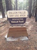 view gallery view galleryE0 km |  Dillon Falls Trailhead - Deschutes River Trail - Oregon Dillon Falls Trailhead - Deschutes River Trail - Oregon
in Hiking and walking trailheads Trailhead at the Dillon Falls Day Use Area. posted by: Volcanoguy location: Oregon date approved: 04/17/2013 last visited: 04/17/2013 |
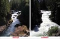
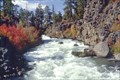 view gallery view galleryE0.5 km |  Dillon Falls, Oregon Dillon Falls, Oregon
in Waterfalls A series of small falls and rapids on the Deschutes River that collectively are known as Dillon Falls. posted by: Volcanoguy location: Oregon date approved: 12/10/2005 last visited: 07/09/2011 |
 view gallery view gallery N1.4 km N1.4 km
|  Turn of the Century Fish Tales - Deschutes County, Oregon Turn of the Century Fish Tales - Deschutes County, Oregon
in Oregon Historical Markers Sign along river trail near Aspen Camp. posted by: Volcanoguy location: Oregon date approved: 03/04/2008 last visited: 07/27/2008 |
 view gallery view galleryN1.6 km |  P-41-1929, Oregon P-41-1929, Oregon
in U.S. Benchmarks U.S. Geological Survey benchmark along old Shevlin-Hixon railroad grade. posted by: Volcanoguy location: Oregon date approved: 04/27/2006 last visited: 04/28/2006 |
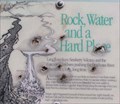 view gallery view gallery S1.9 km S1.9 km
| Rock, Water and a Hard Place - Deschutes County, Oregon in Oregon Historical Markers Sign along river trail below Benham Falls. posted by: Volcanoguy location: Oregon date approved: 06/01/2008 last visited: 06/01/2008 |
 view gallery view galleryS2.1 km | Benham Falls, Oregon in Waterfalls A series of small falls and rapids on the Deschutes River that collectively are known as Benham Falls. posted by: Volcanoguy location: Oregon date approved: 12/09/2005 last visited: 11/19/2021 |
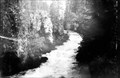 view gallery view galleryS2.1 km |  Benham Falls, Oregon Benham Falls, Oregon
in Photos Then and Now View up Benham Falls in 1903 and 2005. posted by: Volcanoguy location: Oregon date approved: 10/29/2005 last visited: 11/19/2021 |
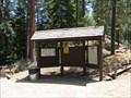 view gallery view galleryS2.1 km | Upper Deschutes Recreation Area near Bend, OR in 'You Are Here' Maps This "You Are Here" sign is in the main parking lot of the Benham Falls, part of the Upper Deschutes Recreation Area. posted by: Queens Blessing location: Oregon date approved: 08/01/2009 last visited: 09/02/2013 |
 view gallery view galleryS2.4 km | BOR BENHAM, OR in U.S. Benchmarks BOR benchmark near head of Benham Falls. posted by: Volcanoguy location: Oregon date approved: 06/01/2008 last visited: 06/01/2008 |
 view gallery view galleryS2.6 km |  Fort Benham, Oregon, “The Indian Fighter” Fort Benham, Oregon, “The Indian Fighter”
in Movie Locations Fort Benham was built in 1955 for the filming of The Indian Fighter staring Kirk Douglas and was used for several other films until 1961. posted by: Volcanoguy location: Oregon date approved: 07/16/2006 last visited: 07/16/2006 |
 view gallery view galleryE2.9 km | BOR Blank - Oregon in U.S. Benchmarks Bureau of Reclamation blank benchmark disk on Lava Butte lava flow. posted by: Volcanoguy location: Oregon date approved: 06/01/2012 last visited: 04/27/2012 |
 view gallery view galleryS2.9 km | Railroad Loading Docks - Deschutes County, Oregon in Oregon Historical Markers History marker along Benham Interpretive Trail. posted by: Volcanoguy location: Oregon date approved: 03/21/2007 last visited: 07/05/2009 |
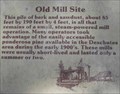 view gallery view galleryS2.9 km | Old Mill Site - Deschutes County, Oregon in Oregon Historical Markers History marker along Benham Interpretive Trail. posted by: Volcanoguy location: Oregon date approved: 03/21/2007 last visited: 07/05/2009 |
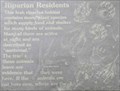 view gallery view galleryS2.9 km |  Riparian Residents - Oregon Riparian Residents - Oregon
in Flora and Fauna Information Signs This sign is located along Benham Interpretive Trail west of parking lot. posted by: Volcanoguy location: Oregon date approved: 05/27/2013 last visited: 04/12/2013 |
 view gallery view galleryS2.9 km | Nathaniel J. Wyeth - Deschutes County, Oregon in Oregon Historical Markers History marker along Benham Interpretive Trail. posted by: Volcanoguy location: Oregon date approved: 03/21/2007 last visited: 07/05/2009 |
 view gallery view galleryS2.9 km | Riparian Area - Oregon in Flora and Fauna Information Signs This sign is located along Benham Interpretive Trail west of parking lot. posted by: Volcanoguy location: Oregon date approved: 05/11/2013 last visited: 05/12/2013 |
 view gallery view galleryS2.9 km | Changing Forest - Deschutes County, Oregon in Oregon Historical Markers History marker along Benham Interpretive Trail. posted by: Volcanoguy location: Oregon date approved: 03/21/2007 last visited: 03/21/2007 |
 view gallery view galleryS3.1 km | Picnic Area - Deschutes County, Oregon in Oregon Historical Markers History marker along Benham Interpretive Trail. posted by: Volcanoguy location: Oregon date approved: 03/21/2007 last visited: 03/21/2007 |
 view gallery view galleryS3.1 km | Benham Falls near Bend, Oregon in 'You Are Here' Maps This sign is at one of the parking lot that leads to Benham Falls. You are at a special place! posted by: Queens Blessing location: Oregon date approved: 08/01/2009 last visited: 07/30/2019 |
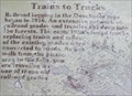 view gallery view galleryS3.1 km | Trains to Trucks - Deschutes County, Oregon in Oregon Historical Markers History marker along Benham Falls Trail. posted by: Volcanoguy location: Oregon date approved: 03/21/2007 last visited: 07/26/2011 |
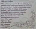 view gallery view galleryS3.1 km | River Ruler - Deschutes County, Oregon in Oregon Historical Markers History marker along Benham Falls Trail. posted by: Volcanoguy location: Oregon date approved: 03/21/2007 last visited: 11/19/2021 |
 view gallery view galleryS3.1 km | Benham Falls Bridge, Oregon in Photos Then and Now The Shevlin-Hixon bridge at Benham Falls was built in 1921 and this photo was taken about 1922. posted by: Volcanoguy location: Oregon date approved: 04/04/2007 last visited: 07/26/2011 |
 view gallery view galleryS3.1 km |  Lava Butte Flow and Deschutes River, Oregon Lava Butte Flow and Deschutes River, Oregon
in Places of Geologic Significance The area near Benham Falls illustrates the interaction of lava flows and rivers. posted by: Volcanoguy location: Oregon date approved: 03/18/2007 last visited: 07/04/2012 |
 view gallery view galleryS3.1 km |  Benham Falls Bridge, OR Benham Falls Bridge, OR
in Orphaned Bridges The Shevlin-Hixon bridge at Benham Falls was built in 1921. posted by: Volcanoguy location: Oregon date approved: 03/20/2007 last visited: 07/26/2011 |
|