
Dillon Falls, Oregon
Posted by:  Volcanoguy
N 43° 57.470 W 121° 24.635
10T E 627520 N 4868417
A series of small falls and rapids on the Deschutes River that collectively are known as Dillon Falls.
Waymark Code: WM4RT
Location: Oregon, United States
Date Posted: 12/10/2005
Views: 80
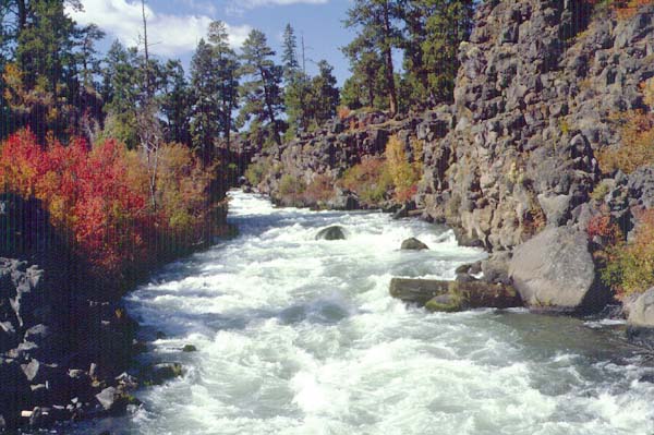
Dillon Falls on the Deschutes River consists of a series of small falls and rapids where the river drops 50 feet over a distance of a quarter mile. For more information on Benham Falls check the Waterfalls of the Pacific Northwest Website.
Please post a photo at Dillon Falls when you log this waymark.
Geologic History of Dillon Falls
As Newberry Volcano has grown over the last half million years it has gradually been displacing the Deschutes River westward. Over the last 100,000 years, two eruptions have shaped the Benham-Dillon Falls area. Prior to 80,000 years ago, the Deschutes River was located somewhere to the east between Benham Buttes and Green Mountain (north of Lava Butte). About 80,000 years ago an eruption on the northwest flank of Newberry produce a large tube-fed basalt flow that moved north and west. Much of the flow passed through Lava River Cave and another branch went north to underlie Bend and extend almost to Redmond. This large flow destroyed the previous river channel and over time a new channel was established along the western edge of the flow against the edge of Benham Buttes (a group of 1,800,000 year old rhyodacite domes). Over the next 70,000 years the river deepened new channel.
Prior to the eruption of Lava Butte (7000 years ago), the Deschutes River occupied a canyon (80 to 100 feet deep) from Bend to a point several miles upstream from Benham Falls. The eruption of Lava Butte again blocked the Deschutes River. The lava flows filled the deep canyon of the Deschutes from the Benham Falls area to Dillon Falls area with more than 100 feet of lava and formed a dam resulting in a lake which extended up river beyond the Sunriver area. As the lake rose, the lowest point was a low saddle on Benham Buttes. As the lake overflowed it cut the channel that is now Benham Falls. Below Benham Falls the river follows the edge of the Lava Butte until it reaches Dillon Falls where the river cascades down into the original river channel. Map of Lava Butte Flows and Deschutes River