 view gallery view gallery W1.9 km W1.9 km
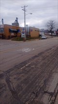
|   Nation's First Watershed Project Historical Marker Nation's First Watershed Project Historical Marker
in Wisconsin Historical Markers Nation's First Watershed Project Historical Marker on Hwy 14 1/2 mile west of Coon Valley, WI posted by:  onfire4jesus onfire4jesus location: Wisconsin date approved: 08/16/2007 last visited: 07/15/2017 |
 view gallery view galleryW1.9 km |  FIRST - Nation's First Watershed Project FIRST - Nation's First Watershed Project
in First of its Kind Nation's First Watershed Project Historical Marker on Hwy 14 1/2 mile west of Coon Valley, Wisconsin posted by: onfire4jesus location: Wisconsin date approved: 07/30/2007 last visited: 07/15/2017 |
 view gallery view gallery NE3.7 km NE3.7 km
|  James Nestigen - Coon Valley, WI, USA James Nestigen - Coon Valley, WI, USA
in Dedicated Trees Located at the Norskedalen Nature and Heritage Center in Coon Valley, Wisconsin, this tree grows in memory of a former director who served from 1990 to 1994. posted by: mrjcanger location: Wisconsin date approved: 10/12/2016 last visited: never |
 view gallery view galleryNE3.9 km |  Zerogee II - Coon Valley, WI, USA Zerogee II - Coon Valley, WI, USA
in Figurative Public Sculpture Located in the Gundersen Arboretum at Norskedalen Nature & Heritage Center, this work of art was constructed in honor of Helga Gundersen by nationally known sculptor Paul T. Granlund. posted by: mrjcanger location: Wisconsin date approved: 10/15/2016 last visited: never |
 view gallery view galleryNE3.9 km |  Gundersen Arboretum WCC Hiking Bridge - Coon Valley, WI, USA Gundersen Arboretum WCC Hiking Bridge - Coon Valley, WI, USA
in Arch Bridges After the CCC disbanded in the late 1930's Wisconsin continued with its own Wisconsin Conservation Corps. This small arch bridge was one of their structures. posted by: mrjcanger location: Wisconsin date approved: 10/13/2016 last visited: never |
 view gallery view gallery N4.2 km N4.2 km
|  Hutchens Blacksmith Shop (Norskedalen) - Coon Valley, WI, USA Hutchens Blacksmith Shop (Norskedalen) - Coon Valley, WI, USA
in Blacksmith Shops This 1800's building was moved to Norskedalen and is being used as its blacksmith shop during living history presentations. The foundry is fully functional and they still make the nails and horseshoes used at the center today. posted by: mrjcanger location: Wisconsin date approved: 11/09/2016 last visited: never |
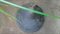
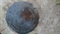
 view gallery view gallery SE11.7 km SE11.7 km
|  JEFFERSON C GPS Control Station - Jefferson, WI JEFFERSON C GPS Control Station - Jefferson, WI
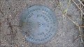
in U.S. Benchmarks This disk sites just off of County Hwy B and was placed in 2004. posted by: mrjcanger location: Wisconsin date approved: 09/30/2016 last visited: never |
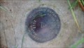
 view gallery view gallerySE12.7 km | 3D09 Control Station - Jefferson, WI in U.S. Benchmarks This disk was placed just North of County Hwy Y in 2004 by the Wisconsin Department of Transportation. posted by: mrjcanger location: Wisconsin date approved: 09/30/2016 last visited: never |
 view gallery view gallery NW13 km NW13 km
| The Coulee Region - La Crosse, WI in Wisconsin Historical Markers This marker is located in a wayside on Hwy 33 5 miles east of La Crosse, WI. posted by: onfire4jesus location: Wisconsin date approved: 11/09/2008 last visited: 07/25/2011 |
 view gallery view gallery E13.2 km E13.2 km
|  Alden "Frem" Fremstad - Westby, WI, USA Alden "Frem" Fremstad - Westby, WI, USA
in Firefighter Memorials Dedicated on July 4, 2010, this memorial honors the fire chief of Westby from 1972-1989. posted by: mrjcanger location: Wisconsin date approved: 09/29/2016 last visited: never |
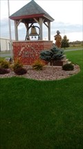
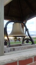 view gallery view galleryE13.2 km |  Westby-Christiana Fire & Rescue Monument Bell - Westby, WI, USA Westby-Christiana Fire & Rescue Monument Bell - Westby, WI, USA
in Bells Within the memorial for "Frem" Fremstad, just outside of the Westby-Christiana Fire Department, this bell is displayed at about four feet from the ground. posted by: mrjcanger location: Wisconsin date approved: 09/29/2016 last visited: never |
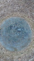
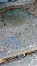 view gallery view gallerySE13.4 km | 1298 Survey Disk - Westby, WI in U.S. Benchmarks Located at the base of the building at Dregne's Scandinavian Gifts, this disk is a true hide and seek find. posted by: mrjcanger location: Wisconsin date approved: 09/30/2016 last visited: never |
 view gallery view gallerySE13.5 km |  Westby Co-op Creamery - Westby, WI, USA Westby Co-op Creamery - Westby, WI, USA
in Dairy Creameries One of the best things about Wisconsin is the dairy, and there's almost no better dairy in the state that the Westby Co-op. This is their main creamery location in the heart of Westby. posted by: mrjcanger location: Wisconsin date approved: 11/22/2016 last visited: never |
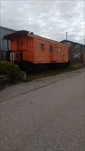 view gallery view gallerySE13.5 km |  Milwaukee Road caboose 992091 - Westby, WI, USA Milwaukee Road caboose 992091 - Westby, WI, USA
in Train Cabooses Now retired as a static display just outside of the Westby Railroad Museum, this caboose was one of many that served on the Milwaukee Road. posted by: mrjcanger location: Wisconsin date approved: 11/01/2016 last visited: never |
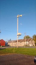 view gallery view gallerySE13.5 km |  Bekkedal Avenue - Westby, WI, USA Bekkedal Avenue - Westby, WI, USA
in Outdoor Warning Sirens Standing by itself to warn the small town of just over 2,000 people of weather emergencies. posted by: mrjcanger location: Wisconsin date approved: 10/02/2016 last visited: never |
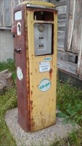 view gallery view gallerySE13.5 km |  Tokheim 39 Tall - Westby, WI, USA Tokheim 39 Tall - Westby, WI, USA
in Vintage Gasoline Pumps Sitting just outside of what use to be one of the Bekkedal Tobacco Leaf Company warehouse, this vintage gas pump remains as a ghost of a time gone by. posted by: mrjcanger location: Wisconsin date approved: 10/18/2016 last visited: never |
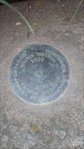
 view gallery view gallerySE13.8 km | 3R49 Control Station - Westby, WI in U.S. Benchmarks In between Westby and Viroqua on US 61, South of Smith Road, this disk was set in 2012 and is marked by three white witness posts. posted by: mrjcanger location: Wisconsin date approved: 09/23/2016 last visited: never |
 view gallery view gallerySE15 km | 3D10 Control Station - Viroqua, WI in U.S. Benchmarks This disk was placed by the Wisconsin Department of Transportation in 2004 on the abutment of a culvert. posted by: mrjcanger location: Wisconsin date approved: 09/23/2016 last visited: never |
 view gallery view gallerySE15.1 km | 3R48 Control Station - Viroqua, WI in U.S. Benchmarks Located just off County Hwy Y next to the bike trail that runs next to US 61, this disked is marked by two white witness posts. posted by: mrjcanger location: Wisconsin date approved: 09/23/2016 last visited: never |
 view gallery view galleryW16.1 km |  Shady Maple Overlook – LaCrosse, Wisconsin Shady Maple Overlook – LaCrosse, Wisconsin
in Birdwatching Locations What better place to watch for birds than the small parking area overlooking Goose Island! posted by: wildernessmama location: Wisconsin date approved: 06/21/2015 last visited: never |
 view gallery view gallery S16.1 km S16.1 km
| HARMONY E GPS Control Station - Harmony Township, WI in U.S. Benchmarks Set just off of County Highway N, this disk is a control station for the Wisconsin DOT. posted by: mrjcanger location: Wisconsin date approved: 10/21/2016 last visited: never |
 view gallery view gallerySE16.6 km | VIROQUA GPS 2 Control Station - Viroqua, WI in U.S. Benchmarks This disk placed by the Wisconsin DOT in 2012, sits atop a ridge just of US61. posted by: mrjcanger location: Wisconsin date approved: 09/29/2016 last visited: never |
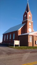 view gallery view galleryNE16.7 km |  Fish Creek Ridge Lutheran Church - Rockland, WI, Fish Creek Ridge Lutheran Church - Rockland, WI,
in Country Churches A long drive up hill on County Highway J brings you to the intersection with County Highway Y and just a little ways further is this amazing 1894 built church. posted by: mrjcanger location: Wisconsin date approved: 11/22/2016 last visited: never |
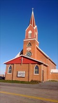 view gallery view galleryNE16.7 km | FISH CREEK RIDGE CHURCH SPIRE - Rockland, WI in U.S. Benchmarks Back in 1930, CGS decided to mark this church spire as a survey benchmark. Today this church that was built in 1894 still stands with the same spire. posted by: mrjcanger location: Wisconsin date approved: 11/22/2016 last visited: never |
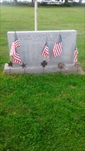 view gallery view gallerySE17.1 km |  Vernon County Cemetery - Viroqua, WI, USA Vernon County Cemetery - Viroqua, WI, USA
in Worldwide Cemeteries Located just outside of the old Vernon County Poor Farm and Asylum, this cemetery served as the final resting place for many who were residents of the institution. posted by: mrjcanger location: Wisconsin date approved: 09/14/2016 last visited: never |
|