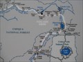
 view gallery view gallery N8.5 km N8.5 km
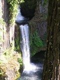
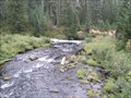
|   Watson Falls, Oregon Watson Falls, Oregon
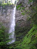
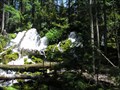
in Waterfalls The spectacular Watson Falls on Watson Creek, a tributary to the Clearwater River. posted by:  Volcanoguy Volcanoguy location: Oregon date approved: 12/13/2005 last visited: 07/09/2009 |
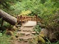 view gallery view galleryN8.7 km |  Watson Falls Trail Bridge - Oregon Watson Falls Trail Bridge - Oregon
in Hiking Path Footbridges This elevated wooden bridge is about half way up the beautiful 1/4 mi trail to 272 ft-high Watson Falls in Douglas County, Oregon. It takes a curve over the creek with a spectacular view of the falls, and the creek below. posted by: silverquill location: Oregon date approved: 05/28/2009 last visited: never |
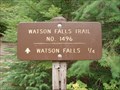 view gallery view galleryN9 km |  Watson Falls Trail No 1496 - Douglas County, OR Watson Falls Trail No 1496 - Douglas County, OR
in Hiking and walking trailheads Watson Falls trail leads to a spectacular 272 foot-high waterfall in the Cascade Mountains of Oregon. It is well maintained and a moderate, but brisk ascent to the falls. Access is from Hwy. 138. There is a large paved parking area and facilites. posted by: silverquill location: Oregon date approved: 05/29/2009 last visited: never |
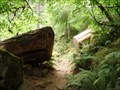 view gallery view galleryN9 km |  Watson Falls Trail - Douglas County, OR Watson Falls Trail - Douglas County, OR
in Scenic Hikes Rated difficult, the trail ascends to the base of the highest waterfall in southern Oregon, 272 foot-high Watson Falls. The trail offers vistas of the fall as a bridge crosses Watson Creek, views of the valley and magnificent stands of Douglas Fir. posted by: silverquill location: Oregon date approved: 05/29/2009 last visited: never |
 view gallery view gallery NE11.4 km NE11.4 km
|  Whitehorse Falls, Umpqua Natl Forest, OR Whitehorse Falls, Umpqua Natl Forest, OR
in 'You Are Here' Maps Whitehorse Falls is a beautiful park with a lovely waterfall, lots of moss, and an You Are Here sign! posted by: Queens Blessing location: Oregon date approved: 07/23/2009 last visited: 09/02/2013 |
 view gallery view galleryN11.6 km | Toketee Falls, Oregon in Waterfalls The spectacular Toketee Falls on North Umpqua River. posted by: Volcanoguy location: Oregon date approved: 12/13/2005 last visited: 05/06/2023 |
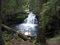 view gallery view galleryNE11.6 km | Whitehorse Falls, Umpqua Natl Forest, OR in Waterfalls Whitehorse Falls is a small 15 foot tall punchbowl type waterfall. posted by: Queens Blessing location: Oregon date approved: 07/22/2009 last visited: 09/02/2013 |
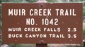 view gallery view gallery S13.4 km S13.4 km
| Muir Creek Trailhead - Oregon in Hiking and walking trailheads Rogue River National Forest trailhead on the Muir Creek Trail, #1042. posted by: Volcanoguy location: Oregon date approved: 11/23/2009 last visited: 08/28/2009 |
 view gallery view galleryS13.4 km |  CONFLUENCE - Muir Creek - Rogue River CONFLUENCE - Muir Creek - Rogue River
in River Origins, Destinations and Confluences The confluence of Muir Creek with the Rogue River. posted by: Volcanoguy location: Oregon date approved: 11/23/2009 last visited: 08/28/2009 |
 view gallery view gallery SE15.9 km SE15.9 km
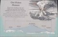
|  One Violent Moment One Violent Moment
in Oregon Historical Markers One of two geologic history sign at the Crater Rim Viewpoint on Ore. Hwy. 230.
posted by: Volcanoguy location: Oregon date approved: 11/23/2009 last visited: 08/28/2009 |
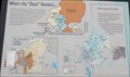 view gallery view gallerySE15.9 km | When the “Dust” Settled... in Oregon Historical Markers One of two geologic history sign at the Crater Rim Viewpoint on Ore. Hwy. 230.
posted by: Volcanoguy location: Oregon date approved: 11/23/2009 last visited: 08/28/2009 |
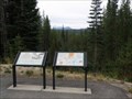
 view gallery view gallerySE15.9 km |  Crater Rim Viewpoint - Oregon Crater Rim Viewpoint - Oregon
in Scenic Roadside Look-Outs Viewpoint on Ore. Hwy. 230 for the rim at Crater Lake. posted by: Volcanoguy location: Oregon date approved: 11/22/2009 last visited: 11/27/2020 |
 view gallery view gallerySE15.9 km |  Rogue-Umpqua Scenic Byway - Crater Rim Viewpoint - Oregon Rogue-Umpqua Scenic Byway - Crater Rim Viewpoint - Oregon
in National Scenic Byways Viewpoint on Ore. Hwy. 230 which provides a view of high points on the rim of Crater Lake. posted by: Volcanoguy location: Oregon date approved: 11/24/2009 last visited: 08/28/2009 |
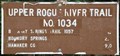 view gallery view gallerySE15.9 km | Crater Rim VP Trailhead - Oregon in Hiking and walking trailheads Rogue River National Forest trailhead for the Upper Rogue River Trail, #1034. posted by: Volcanoguy location: Oregon date approved: 11/22/2009 last visited: 08/28/2009 |
 view gallery view galleryNE16.3 km | Clearwater Falls, Oregon in Waterfalls Clearwater Falls is a small falls on the Clearwater River. posted by: Volcanoguy location: Oregon date approved: 12/13/2005 last visited: 07/09/2009 |
 view gallery view gallerySE17.1 km |  Ore. Hwy. 230 Summit 5415 feet, Oregon Ore. Hwy. 230 Summit 5415 feet, Oregon
in Elevation Signs Elevation sign at summit of Ore. Hwy. 230. posted by: Volcanoguy location: Oregon date approved: 11/22/2009 last visited: 10/09/2011 |
 view gallery view gallery E18.3 km E18.3 km
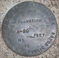
|  PC0131 - BPR A-20, Oregon PC0131 - BPR A-20, Oregon
in U.S. Benchmarks Bureau of Public Roads elevation mark A-20. posted by: Volcanoguy location: Oregon date approved: 11/22/2009 last visited: 08/28/2009 |
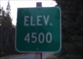 view gallery view galleryNE20 km | Elev. 4500 - Rt. 138 North Umpqua Hwy, OR in Elevation Signs The 4,500 foot elevation marker on Route 138, also known as The North Umpqua Highway, or the "Diamond Lake Cutoff" in the Cascade Mountains of Oregon. posted by: silverquill location: Oregon date approved: 12/21/2007 last visited: never |
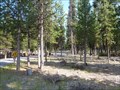 view gallery view galleryE20.3 km |  Broken Arrow, Diamond Lake, Oregon Broken Arrow, Diamond Lake, Oregon
in Campgrounds Beautiful spot to camp away from the crowds posted by: gypsie2 location: Oregon date approved: 01/14/2015 last visited: never |
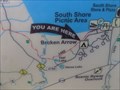 view gallery view galleryE20.3 km | You are Here at Broken Arrow, Diamond Lake, OR in 'You Are Here' Maps Finding where you are in relation to the lake. posted by: gypsie2 location: Oregon date approved: 01/05/2015 last visited: never |
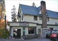 view gallery view galleryE20.4 km |  Chemult, Oregon 97731 ~ Diamond Lake Station Chemult, Oregon 97731 ~ Diamond Lake Station
in U.S. Post Offices This Post Office is inside the Diamond Lake Lodge located at 350 Resort Drive in Diamond Lake, Oregon. posted by: brwhiz location: Oregon date approved: 10/30/2013 last visited: 07/26/2021 |
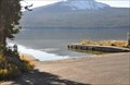 view gallery view galleryE20.4 km |  Diamond Lake Boat Ramp Diamond Lake Boat Ramp
in Boat Ramps This boat ramp is located at the Diamond Lake Resort on the eastern shore of Diamond Lake. posted by: brwhiz location: Oregon date approved: 11/30/2013 last visited: never |
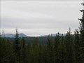
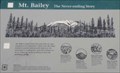 view gallery view galleryE20.8 km | Mt. Bailey in Oregon Historical Markers Geologic history sign at the Mt. Thielsen Viewpoint on Ore. Hwy. 230. posted by: Volcanoguy location: Oregon date approved: 11/23/2009 last visited: 08/28/2009 |
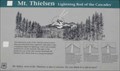 view gallery view galleryE20.8 km | Mt. Thielsen in Oregon Historical Markers Geologic history sign at the Mt. Thielsen Viewpoint on Ore. Hwy. 230. posted by: Volcanoguy location: Oregon date approved: 11/23/2009 last visited: 08/28/2009 |
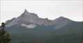 view gallery view galleryE20.8 km | Mt. Thielsen Viewpoint - Oregon in Scenic Roadside Look-Outs Viewpoint on Ore. Hwy. 230 for Mt. Thielsen. posted by: Volcanoguy location: Oregon date approved: 11/22/2009 last visited: 11/27/2020 |
|